

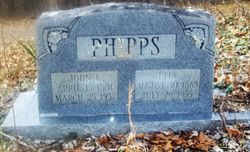
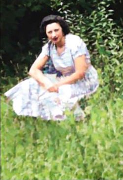
Mary Etta Wykle Phipps
| Birth | : | 30 Jul 1885 Oak Hill, Fayette County, West Virginia, USA |
| Death | : | 26 Jul 1955 Shady Spring, Raleigh County, West Virginia, USA |
| Burial | : | Green Valley Cemetery, Rescue, El Dorado County, USA |
| Coordinate | : | 38.6993790, -121.0081406 |
| Description | : | Rites Thursday For Mrs. Phipps Funeral services will be conduct- ed at 2:30 p.m. Thursday at the Matsville Methodist Church, for Mary Etta Phipps, 70, Shady Spring, who died at 9 a.m. Tues- day at the home of her daughter, Mrs. Opahleene Eppard, Shady Springs. The Rev. James Godby will Offi- ciate and burial will be made in the Caperton Cemetery, Matsville. She was born July 30, 1885 at Oak Hill, the daughter of Penn and Mary Wykle. She was a member of the Metho- dist Church at Matsville and had been a resident of Raleigh County 35 years. Survivors include two sons, Virgil Phipps of... Read More |
frequently asked questions (FAQ):
-
Where is Mary Etta Wykle Phipps's memorial?
Mary Etta Wykle Phipps's memorial is located at: Green Valley Cemetery, Rescue, El Dorado County, USA.
-
When did Mary Etta Wykle Phipps death?
Mary Etta Wykle Phipps death on 26 Jul 1955 in Shady Spring, Raleigh County, West Virginia, USA
-
Where are the coordinates of the Mary Etta Wykle Phipps's memorial?
Latitude: 38.6993790
Longitude: -121.0081406
Family Members:
Parent
Spouse

Siblings
Children
Flowers:


Nearby Cemetories:
1. Green Valley Cemetery
Rescue, El Dorado County, USA
Coordinate: 38.6993790, -121.0081406
2. Saint Michaels Catholic Cemetery
Cameron Park, El Dorado County, USA
Coordinate: 38.6995010, -120.9985886
3. Skinner Ranch Cemetery
Cameron Park, El Dorado County, USA
Coordinate: 38.6981812, -120.9972763
4. Rust Family Gravesite
Cameron Park, El Dorado County, USA
Coordinate: 38.6980160, -121.0207130
5. Litten-McDonald Cemetery
Rescue, El Dorado County, USA
Coordinate: 38.7078750, -120.9628310
6. Jayhawk Cemetery
Rescue, El Dorado County, USA
Coordinate: 38.7308006, -120.9627991
7. Morrison Ranch Family Cemetery
Clarksville, El Dorado County, USA
Coordinate: 38.6552887, -121.0368500
8. Railroad House Cemetery
Clarksville, El Dorado County, USA
Coordinate: 38.6575699, -121.0516129
9. Duroc House Cemetery
Shingle Springs, El Dorado County, USA
Coordinate: 38.6528860, -120.9701690
10. Rose Springs Cemetery
Rescue, El Dorado County, USA
Coordinate: 38.7146150, -120.9398390
11. Clarksville Cemetery
Clarksville, El Dorado County, USA
Coordinate: 38.6546707, -121.0615387
12. Planters House Cemetery
Shingle Springs, El Dorado County, USA
Coordinate: 38.6645820, -120.9321300
13. Shingle Springs Cemetery
Shingle Springs, El Dorado County, USA
Coordinate: 38.6648903, -120.9270325
14. Meyer-Zentgraf Cemetery
Shingle Springs, El Dorado County, USA
Coordinate: 38.6710620, -120.9158490
15. Mormon Island Relocation Cemetery
El Dorado Hills, El Dorado County, USA
Coordinate: 38.6986084, -121.1093521
16. Heusner Ranch Family Cemetery
Buckeye, El Dorado County, USA
Coordinate: 38.6675770, -120.9135260
17. Frenchtown Cemetery
Frenchtown, El Dorado County, USA
Coordinate: 38.6421585, -120.9132309
18. Greenstone Cemetery
Shingle Springs, El Dorado County, USA
Coordinate: 38.6749020, -120.8869240
19. Gold Hill Cemetery
Gold Hill, El Dorado County, USA
Coordinate: 38.7604010, -120.8849970
20. Cold Springs Cemetery
Cold Springs, El Dorado County, USA
Coordinate: 38.7441444, -120.8721619
21. Wakamastu Tea and Silk Farm Colony Burial Site
Coloma, El Dorado County, USA
Coordinate: 38.7674100, -120.8858100
22. Bryant Cemetery
Latrobe, El Dorado County, USA
Coordinate: 38.5830383, -120.9679184
23. Schenck Ranch Cemetery
Frenchtown, El Dorado County, USA
Coordinate: 38.5961120, -120.9281020
24. Folsom Prison Cemetery
Folsom, Sacramento County, USA
Coordinate: 38.6952860, -121.1636690