

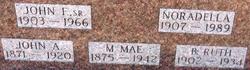
Mary Florence “Flora” Koontz McKelvy
| Birth | : | 18 Nov 1858 Saint Louisville, Licking County, Ohio, USA |
| Death | : | 20 May 1942 Chatham, Licking County, Ohio, USA |
| Burial | : | St Mary's Churchyard, Burford, Shropshire Unitary Authority, England |
| Coordinate | : | 52.3087670, -2.6126000 |
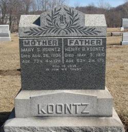
| Description | : | McKelvy, Flora Koontz 18 Nov. 1858 – 20 May 1942 Mrs. Flora McKelvy, 83, widow of Dr. J. K. McKelvy, died Wednesday night in the home of her daughter, Mrs. Harry Stream in Chatham. In failing health several years her condition the past five months had been serious. Mrs. McKelvy was the daughter of the Henry B. and Mary (Coad) Koontz and was born near Saint Louisville. She was married May 20, 1880 to Dr. J.K. McKelvy who practiced medicine in the Chatham area for several years. He died more than two years ago and surviving Mrs. McKelvy are her daughter Mrs.... Read More |
frequently asked questions (FAQ):
-
Where is Mary Florence “Flora” Koontz McKelvy's memorial?
Mary Florence “Flora” Koontz McKelvy's memorial is located at: St Mary's Churchyard, Burford, Shropshire Unitary Authority, England.
-
When did Mary Florence “Flora” Koontz McKelvy death?
Mary Florence “Flora” Koontz McKelvy death on 20 May 1942 in Chatham, Licking County, Ohio, USA
-
Where are the coordinates of the Mary Florence “Flora” Koontz McKelvy's memorial?
Latitude: 52.3087670
Longitude: -2.6126000
Family Members:
Parent

Spouse
Siblings
Flowers:


Nearby Cemetories:
1. St Mary's Churchyard
Burford, Shropshire Unitary Authority, England
Coordinate: 52.3087670, -2.6126000
2. St. Mary's Churchyard
Tenbury Wells, Malvern Hills District, England
Coordinate: 52.3120500, -2.5962400
3. St Michael's Churchyard Extension
Tenbury Wells, Malvern Hills District, England
Coordinate: 52.2941032, -2.6183906
4. St Michael and All Angels Churchyard
Tenbury Wells, Malvern Hills District, England
Coordinate: 52.2882600, -2.6137900
5. St. Mary Magdalene Churchyard
Little Hereford, Herefordshire Unitary Authority, England
Coordinate: 52.3112129, -2.6572039
6. St Michael and All Angels Churchyard
Rochford, Malvern Hills District, England
Coordinate: 52.3134240, -2.5454090
7. St Michael & All Angels Churchyard
Knighton-on-Teme, Malvern Hills District, England
Coordinate: 52.3260900, -2.5393500
8. St. Mary's Churchyard
Caynham, Shropshire Unitary Authority, England
Coordinate: 52.3558260, -2.6564540
9. St Marys Churchyard
Kyre, Malvern Hills District, England
Coordinate: 52.2685140, -2.5488360
10. St. Peter's Churchyard
Coreley, Shropshire Unitary Authority, England
Coordinate: 52.3627780, -2.5694950
11. St. Andrew, Ashford Bowdler.
Ashford Bowdler, Shropshire Unitary Authority, England
Coordinate: 52.3308770, -2.7065930
12. Knowbury, St Paul
Caynham, Shropshire Unitary Authority, England
Coordinate: 52.3734750, -2.6300130
13. St Peter & St Paul Churchyard
Eastham, Malvern Hills District, England
Coordinate: 52.3156100, -2.5046000
14. St. Peter's Churchyard
Stoke Bliss, Malvern Hills District, England
Coordinate: 52.2627200, -2.5121300
15. St. James the Less Churchyard
Kimbolton, Herefordshire Unitary Authority, England
Coordinate: 52.2507757, -2.6957349
16. St. John the Baptist Churchyard
Doddington, Cheshire East Unitary Authority, England
Coordinate: 52.3822068, -2.5651644
17. St Lawrence Churchyard
Lindridge, Malvern Hills District, England
Coordinate: 52.3180700, -2.4779300
18. St. Mary's Churchyard
Bitterley, Shropshire Unitary Authority, England
Coordinate: 52.3922280, -2.6319790
19. Hopton Bank Methodist Church Burial Ground
Hopton Wafers, Shropshire Unitary Authority, England
Coordinate: 52.3872950, -2.5584430
20. St. Peter and St. Paul
Leominster, Herefordshire Unitary Authority, England
Coordinate: 52.2704100, -2.7398260
21. St. Michael & All Angels Churchyard
Hopton Wafers, Shropshire Unitary Authority, England
Coordinate: 52.3857100, -2.5343700
22. St John the Baptist Churchyard
Mamble, Malvern Hills District, England
Coordinate: 52.3416520, -2.4586520
23. St Mary the Virgin
Cleobury Mortimer, Shropshire Unitary Authority, England
Coordinate: 52.3792280, -2.4803610
24. St Bartholomews Churchyard
Bayton, Malvern Hills District, England
Coordinate: 52.3562100, -2.4548200