
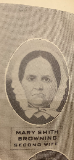

Mary M. Smith Browning
| Birth | : | unknown |
| Death | : | 8 Sep 1857 |
| Burial | : | Jewish Cemetery, Nottingham, Nottingham Unitary Authority, England |
| Coordinate | : | 52.9123890, -1.1372670 |
| Inscription | : | SECOND WIFE OF M. BROWNING |
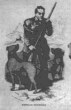
| Description | : | Meshack Browning and Mary F. Smith were married April 23, 1841 in Cumberland MD. Mary had a first stroke of Palsy on February 14, 1855, which she survived. The second stroke was September 8, 1857, from which she survived for only 25 minutes. "Forty Years in the Life of a Hunter," by Meshack Browning, Pg 352. |
frequently asked questions (FAQ):
-
Where is Mary M. Smith Browning's memorial?
Mary M. Smith Browning's memorial is located at: Jewish Cemetery, Nottingham, Nottingham Unitary Authority, England.
-
When did Mary M. Smith Browning death?
Mary M. Smith Browning death on 8 Sep 1857 in
-
Where are the coordinates of the Mary M. Smith Browning's memorial?
Latitude: 52.9123890
Longitude: -1.1372670
Family Members:
Spouse
Flowers:


Nearby Cemetories:
1. Jewish Cemetery
Nottingham, Nottingham Unitary Authority, England
Coordinate: 52.9123890, -1.1372670
2. Southern Cemetery and Crematorium
West Bridgford, Rushcliffe Borough, England
Coordinate: 52.9113900, -1.1408500
3. Edwalton Holy Rood Churchyard
West Bridgford, Rushcliffe Borough, England
Coordinate: 52.9093000, -1.1114170
4. St. Giles's Church & Churchyard
West Bridgford, Rushcliffe Borough, England
Coordinate: 52.9316460, -1.1288450
5. St. Peter's Churchyard
Ruddington, Rushcliffe Borough, England
Coordinate: 52.8925940, -1.1506460
6. Flawford St Peter
Ruddington, Rushcliffe Borough, England
Coordinate: 52.8934800, -1.1201300
7. Ruddington Old Cemetery
Ruddington, Rushcliffe Borough, England
Coordinate: 52.8914500, -1.1531400
8. St Peter New Churchyard
Ruddington, Rushcliffe Borough, England
Coordinate: 52.8914800, -1.1549600
9. Wilford Village Cemetery
Wilford, Nottingham Unitary Authority, England
Coordinate: 52.9338540, -1.1591170
10. St. Wilfrid Churchyard
Wilford, Nottingham Unitary Authority, England
Coordinate: 52.9346290, -1.1587770
11. St Mary's Churchyard
Clifton, Nottingham Unitary Authority, England
Coordinate: 52.9083870, -1.1965435
12. St. Mary The Virgin Churchyard
Plumtree, Rushcliffe Borough, England
Coordinate: 52.8918690, -1.0874320
13. National Justice Museum High Pavement Nottingham
Nottingham Unitary Authority, England
Coordinate: 52.9510680, -1.1443050
14. St Nicholas Churchyard
Nottingham, Nottingham Unitary Authority, England
Coordinate: 52.9504780, -1.1509220
15. National Ice Centre
Nottingham, Nottingham Unitary Authority, England
Coordinate: 52.9527790, -1.1394460
16. St Peters Church Yard
Nottingham, Nottingham Unitary Authority, England
Coordinate: 52.9522800, -1.1486940
17. St Mary's Burial Grounds
Nottingham, Nottingham Unitary Authority, England
Coordinate: 52.9527860, -1.1419160
18. Holy Trinity Churchyard
Lenton, Nottingham Unitary Authority, England
Coordinate: 52.9485630, -1.1753148
19. Cathedral Church of St. Barnabas
Nottingham, Nottingham Unitary Authority, England
Coordinate: 52.9546750, -1.1570460
20. St. Mary Rest Ground
Nottingham, Nottingham Unitary Authority, England
Coordinate: 52.9568310, -1.1406580
21. General Cemetery
Nottingham, Nottingham Unitary Authority, England
Coordinate: 52.9561430, -1.1615420
22. Beeston Baptist Chapel
Beeston, Broxtowe Borough, England
Coordinate: 52.9246600, -1.2122000
23. Nottingham General Cemetery
Nottingham, Nottingham Unitary Authority, England
Coordinate: 52.9575370, -1.1594236
24. St. John the Baptist Churchyard
Beeston, Broxtowe Borough, England
Coordinate: 52.9255562, -1.2167680