
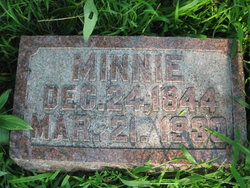
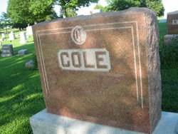
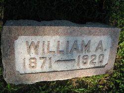
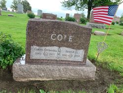
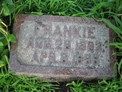
Mary “Minnie” Otis Cole
| Birth | : | 24 Dec 1844 Marietta, Washington County, Ohio, USA |
| Death | : | 21 Mar 1930 Emerson, Mills County, Iowa, USA |
| Burial | : | Pine Grove Cemetery, Boylston, Worcester County, USA |
| Coordinate | : | 42.3582993, -71.7431030 |
| Plot | : | 1st Addition #184 |
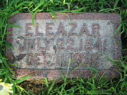
| Description | : | Mrs. E. Cole, mention of whose serious illness was made in last week’s Leader, passed away Friday, March 21, 1930. She was stricken on Thursday, March 13, with, paralysis from which she was unable to rally, although everything possible was donate relieve her, and the end came as stated above. The funeral was held Sunday afternoon at the Presbyterian Church at 2:30 o’clock. Services were conducted by Rev. Paul K. Holland, pastor of the Presbyterian Church. The sermon was given by W. C. McClellan of Corning, a friend of the family for over forty years. A quartet composed of Mr. and Mrs.... Read More |
frequently asked questions (FAQ):
-
Where is Mary “Minnie” Otis Cole's memorial?
Mary “Minnie” Otis Cole's memorial is located at: Pine Grove Cemetery, Boylston, Worcester County, USA.
-
When did Mary “Minnie” Otis Cole death?
Mary “Minnie” Otis Cole death on 21 Mar 1930 in Emerson, Mills County, Iowa, USA
-
Where are the coordinates of the Mary “Minnie” Otis Cole's memorial?
Latitude: 42.3582993
Longitude: -71.7431030
Family Members:
Parent
Spouse
Siblings
Children
Flowers:


Nearby Cemetories:
1. Pine Grove Cemetery
Boylston, Worcester County, USA
Coordinate: 42.3582993, -71.7431030
2. Old Burial Ground
Boylston, Worcester County, USA
Coordinate: 42.3515700, -71.7355300
3. Saint Lukes Cemetery
West Boylston, Worcester County, USA
Coordinate: 42.3833008, -71.7568970
4. Mount Vernon Cemetery
West Boylston, Worcester County, USA
Coordinate: 42.3634650, -71.7804030
5. Beaman Cemetery
West Boylston, Worcester County, USA
Coordinate: 42.3649590, -71.7803600
6. High Plains Cemetery
West Boylston, Worcester County, USA
Coordinate: 42.3889008, -71.7972031
7. Reservoir Pines Cemetery
Clinton, Worcester County, USA
Coordinate: 42.4084900, -71.7109700
8. Cookshire Cemetery
Sterling, Worcester County, USA
Coordinate: 42.4108500, -71.7734800
9. Fairbank Burial Ground
Sterling, Worcester County, USA
Coordinate: 42.4152600, -71.7320000
10. Mountain View Cemetery
Shrewsbury, Worcester County, USA
Coordinate: 42.2999306, -71.7147598
11. Legg Cemetery
Sterling, Worcester County, USA
Coordinate: 42.4070020, -71.7986150
12. West Main Street Cemetery
Shrewsbury, Worcester County, USA
Coordinate: 42.2912600, -71.7420000
13. Notre Dame du Lac Cemetery
Worcester, Worcester County, USA
Coordinate: 42.2910170, -71.7681030
14. Woodlawn Cemetery
Clinton, Worcester County, USA
Coordinate: 42.4185982, -71.6889038
15. Howard Street Cemetery
Northborough, Worcester County, USA
Coordinate: 42.3249000, -71.6475400
16. Chocksett Burial Ground
Sterling, Worcester County, USA
Coordinate: 42.4377000, -71.7555400
17. Old Burying Ground
Berlin, Worcester County, USA
Coordinate: 42.3811646, -71.6375351
18. Saint John's Cemetery
Lancaster, Worcester County, USA
Coordinate: 42.4328003, -71.6977997
19. Hillside Cemetery
Sterling, Worcester County, USA
Coordinate: 42.4410000, -71.7492570
20. Oak Hill Cemetery
Sterling, Worcester County, USA
Coordinate: 42.4417000, -71.7493973
21. Saint Anne's Cemetery
Shrewsbury, Worcester County, USA
Coordinate: 42.2746300, -71.7485400
22. South Berlin Cemetery
Berlin, Worcester County, USA
Coordinate: 42.3652992, -71.6292038
23. Saint Francis Episcopal Church Memorial Garden
Holden, Worcester County, USA
Coordinate: 42.3522800, -71.8588700
24. Old Burying Ground
Holden, Worcester County, USA
Coordinate: 42.3505800, -71.8626000