
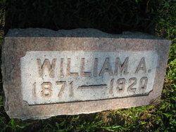
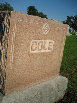
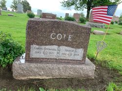
William Andrew Cole
| Birth | : | 17 Sep 1871 Emerson, Mills County, Iowa, USA |
| Death | : | 29 Sep 1920 Emerson, Mills County, Iowa, USA |
| Burial | : | Pine Grove Cemetery, Boylston, Worcester County, USA |
| Coordinate | : | 42.3582993, -71.7431030 |
| Plot | : | 1st Addition #185 |
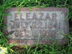
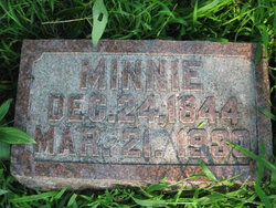
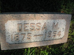
| Description | : | William Andrew Cole (son of Eleazer Cole and Mary (Minnie) Otis) was born September 17, 1871 in Emerson , IA, and died September 29, 1920 in Buried In Emerson Cemetery. He married Dessa Babbitt on September 30, 1896, daughter of Frank Babbitt and Susan Galbraith. DEATH Claims Highly RESPECTED CITIZEN William A. Cole, Resident of Emerson and Vicinity for Many Years, is Summoned Home. September 29, 1920 William A Cole Resident of Emerson With the passing of Wm. A. Cole the community loses one of its best citizens, a man of sterling worth and, one who was liked and respected by all with... Read More |
frequently asked questions (FAQ):
-
Where is William Andrew Cole's memorial?
William Andrew Cole's memorial is located at: Pine Grove Cemetery, Boylston, Worcester County, USA.
-
When did William Andrew Cole death?
William Andrew Cole death on 29 Sep 1920 in Emerson, Mills County, Iowa, USA
-
Where are the coordinates of the William Andrew Cole's memorial?
Latitude: 42.3582993
Longitude: -71.7431030
Family Members:
Parent
Spouse
Siblings
Children
Flowers:


Nearby Cemetories:
1. Pine Grove Cemetery
Boylston, Worcester County, USA
Coordinate: 42.3582993, -71.7431030
2. Old Burial Ground
Boylston, Worcester County, USA
Coordinate: 42.3515700, -71.7355300
3. Saint Lukes Cemetery
West Boylston, Worcester County, USA
Coordinate: 42.3833008, -71.7568970
4. Mount Vernon Cemetery
West Boylston, Worcester County, USA
Coordinate: 42.3634650, -71.7804030
5. Beaman Cemetery
West Boylston, Worcester County, USA
Coordinate: 42.3649590, -71.7803600
6. High Plains Cemetery
West Boylston, Worcester County, USA
Coordinate: 42.3889008, -71.7972031
7. Reservoir Pines Cemetery
Clinton, Worcester County, USA
Coordinate: 42.4084900, -71.7109700
8. Cookshire Cemetery
Sterling, Worcester County, USA
Coordinate: 42.4108500, -71.7734800
9. Fairbank Burial Ground
Sterling, Worcester County, USA
Coordinate: 42.4152600, -71.7320000
10. Mountain View Cemetery
Shrewsbury, Worcester County, USA
Coordinate: 42.2999306, -71.7147598
11. Legg Cemetery
Sterling, Worcester County, USA
Coordinate: 42.4070020, -71.7986150
12. West Main Street Cemetery
Shrewsbury, Worcester County, USA
Coordinate: 42.2912600, -71.7420000
13. Notre Dame du Lac Cemetery
Worcester, Worcester County, USA
Coordinate: 42.2910170, -71.7681030
14. Woodlawn Cemetery
Clinton, Worcester County, USA
Coordinate: 42.4185982, -71.6889038
15. Howard Street Cemetery
Northborough, Worcester County, USA
Coordinate: 42.3249000, -71.6475400
16. Chocksett Burial Ground
Sterling, Worcester County, USA
Coordinate: 42.4377000, -71.7555400
17. Old Burying Ground
Berlin, Worcester County, USA
Coordinate: 42.3811646, -71.6375351
18. Saint John's Cemetery
Lancaster, Worcester County, USA
Coordinate: 42.4328003, -71.6977997
19. Hillside Cemetery
Sterling, Worcester County, USA
Coordinate: 42.4410000, -71.7492570
20. Oak Hill Cemetery
Sterling, Worcester County, USA
Coordinate: 42.4417000, -71.7493973
21. Saint Anne's Cemetery
Shrewsbury, Worcester County, USA
Coordinate: 42.2746300, -71.7485400
22. South Berlin Cemetery
Berlin, Worcester County, USA
Coordinate: 42.3652992, -71.6292038
23. Saint Francis Episcopal Church Memorial Garden
Holden, Worcester County, USA
Coordinate: 42.3522800, -71.8588700
24. Old Burying Ground
Holden, Worcester County, USA
Coordinate: 42.3505800, -71.8626000