


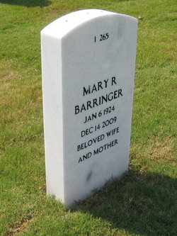
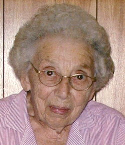
Mary Ruth Holshouser Barringer
| Birth | : | 6 Jan 1924 Rowan County, North Carolina, USA |
| Death | : | 14 Dec 2009 Salisbury, Rowan County, North Carolina, USA |
| Burial | : | St. Peter and St. Paul Churchyard, Shiplake, South Oxfordshire District, England |
| Coordinate | : | 51.4980750, -0.8963940 |
| Plot | : | SECTION I SITE 265 |
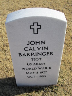
| Description | : | WIFE OF BARRINGER, JOHN CALVIN TSGT US ARMY ∼Widow of John Calvin Barringer, U.S. Army. (U.S. Department of Veterans Affairs). ------- Mary Ruth Holshouser Barringer, 85, of Salisbury, passed away Monday, December 14, 2009 at Genesis ElderCare of Salisbury. Born January 6, 1924 in Rowan County, she was the daughter of the late Maggie Rebecca Lyerly Holshouser & Lewis F. Holshouser. Mrs. Barringer was a graduate of Rockwell High School, class of 1941. She retired from Cannon Mills, Plant No. 7. A member of the First United Church of Christ on Horah Street, she was also an active member of the... Read More |
frequently asked questions (FAQ):
-
Where is Mary Ruth Holshouser Barringer's memorial?
Mary Ruth Holshouser Barringer's memorial is located at: St. Peter and St. Paul Churchyard, Shiplake, South Oxfordshire District, England.
-
When did Mary Ruth Holshouser Barringer death?
Mary Ruth Holshouser Barringer death on 14 Dec 2009 in Salisbury, Rowan County, North Carolina, USA
-
Where are the coordinates of the Mary Ruth Holshouser Barringer's memorial?
Latitude: 51.4980750
Longitude: -0.8963940
Family Members:
Parent

Spouse
Siblings
Children
Flowers:


Nearby Cemetories:
1. St. Peter and St. Paul Churchyard
Shiplake, South Oxfordshire District, England
Coordinate: 51.4980750, -0.8963940
2. St. Mary's Churchyard
Wargrave, Wokingham Borough, England
Coordinate: 51.4998329, -0.8735808
3. St Margaret's Churchyard
Harpsden, South Oxfordshire District, England
Coordinate: 51.5219160, -0.9012270
4. St. Andrew's Churchyard
Sonning, Wokingham Borough, England
Coordinate: 51.4740300, -0.9131640
5. St Mary's Churchyard
Twyford, Wokingham Borough, England
Coordinate: 51.4763850, -0.8673190
6. All Saints Churchyard
Dunsden Green, South Oxfordshire District, England
Coordinate: 51.4917730, -0.9461650
7. Holy Trinity Churchyard
Henley-on-Thames, South Oxfordshire District, England
Coordinate: 51.5338500, -0.9066600
8. Christ Church
Henley-on-Thames, South Oxfordshire District, England
Coordinate: 51.5347880, -0.9032820
9. St. Mary the Virgin Churchyard
Henley-on-Thames, South Oxfordshire District, England
Coordinate: 51.5377790, -0.9017520
10. Reading Cemetery and Crematorium
Caversham, Reading Borough, England
Coordinate: 51.4737690, -0.9546570
11. St. Nicholas' Churchyard
Rotherfield Greys, South Oxfordshire District, England
Coordinate: 51.5351017, -0.9541395
12. St. Peter's Churchyard
Knowl Hill, Windsor and Maidenhead Royal Borough, England
Coordinate: 51.5093351, -0.8126725
13. Caversham Cemetery
Caversham, Reading Borough, England
Coordinate: 51.4745850, -0.9758020
14. Reading Cemetery
Reading, Reading Borough, England
Coordinate: 51.4529450, -0.9480160
15. All Saints Churchyard
Rotherfield Peppard, South Oxfordshire District, England
Coordinate: 51.5280531, -0.9725009
16. St Lawrence Churchyard
Waltham St Lawrence, Windsor and Maidenhead Royal Borough, England
Coordinate: 51.4856000, -0.8066600
17. Mays Lane Burial Ground
Earley, Wokingham Borough, England
Coordinate: 51.4431680, -0.9240020
18. Earley St Peter Churchyard
Earley, Wokingham Borough, England
Coordinate: 51.4434820, -0.9290850
19. Reading Prison Cemetery
Reading, Reading Borough, England
Coordinate: 51.4564910, -0.9641120
20. Henley-on-Thames Cemetery
Henley-on-Thames, South Oxfordshire District, England
Coordinate: 51.5543570, -0.9271320
21. Reading Abbey Ruins
Reading, Reading Borough, England
Coordinate: 51.4563710, -0.9651130
22. St. Peter's Churchyard
Caversham, Reading Borough, England
Coordinate: 51.4686597, -0.9807669
23. St. Laurence Churchyard
Reading, Reading Borough, England
Coordinate: 51.4567474, -0.9686236
24. Kidmore End Cemetery
Kidmore End, South Oxfordshire District, England
Coordinate: 51.5071600, -0.9942160