
| Birth | : | 28 Mar 1928 Cheraw, Chesterfield County, South Carolina, USA |
| Death | : | 20 Jan 2017 Cheraw, Chesterfield County, South Carolina, USA |
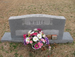
| Burial | : | Pleasant Grove United Methodist Church Cemetery, Cheraw, Chesterfield County, USA |
| Coordinate | : | 34.7048630, -79.9539520 |
| Description | : | Cheraw, SC Mrs. Mary Ruth White Moore, age 88, entered into rest very peacefully on Friday, January 20, 2017. Funeral Services will be 2:00 PM Sunday, January 22, 2017 at Pleasant Grove United Methodist Church by Rev. John Howle and Phillip Caulder, Jr. with burial to follow in the church cemetery. The family will greet friends immediately following the service in the sanctuary of the church. Mrs. Moore was born March 28, 1928 in Cheraw, SC a daughter of the late John Wiley and Virginia Davis White. She was a graduate of Cheraw High School Class of 1945. A devoted and faithful... Read More |
frequently asked questions (FAQ):
-
Where is Mary Ruth White Moore's memorial?
Mary Ruth White Moore's memorial is located at: Pleasant Grove United Methodist Church Cemetery, Cheraw, Chesterfield County, USA.
-
When did Mary Ruth White Moore death?
Mary Ruth White Moore death on 20 Jan 2017 in Cheraw, Chesterfield County, South Carolina, USA
-
Where are the coordinates of the Mary Ruth White Moore's memorial?
Latitude: 34.7048630
Longitude: -79.9539520
Family Members:
Parent

Spouse

Siblings
Children
Flowers:


Nearby Cemetories:
1. Pleasant Grove United Methodist Church Cemetery
Cheraw, Chesterfield County, USA
Coordinate: 34.7048630, -79.9539520
2. Prince Of Peace Church Cemetery
Cheraw, Chesterfield County, USA
Coordinate: 34.7076230, -79.9484660
3. Smithville Cemetery
Chesterfield County, USA
Coordinate: 34.7047005, -79.9669037
4. Saint Paul Missionary Baptist Church
Cheraw, Chesterfield County, USA
Coordinate: 34.7109260, -79.9745410
5. Saint Josephs Cemetery
Cheraw, Chesterfield County, USA
Coordinate: 34.7175410, -79.9702010
6. Progressive Church of Our Lord Jesus Christ Cemete
Cheraw, Chesterfield County, USA
Coordinate: 34.6910300, -79.9387430
7. Midway Baptist Church Cemetery
Cheraw, Chesterfield County, USA
Coordinate: 34.7170570, -79.9826580
8. Robinson Zion Church
Cheraw, Chesterfield County, USA
Coordinate: 34.7328090, -79.9323420
9. J. C. Broome Memorial Garden
Cheraw, Chesterfield County, USA
Coordinate: 34.6753830, -79.9346970
10. Faith Freewill Baptist Church Cemetery
Cheraw, Chesterfield County, USA
Coordinate: 34.6717450, -79.9451980
11. Goodman Creek Missionary Baptist Church
Cheraw, Chesterfield County, USA
Coordinate: 34.7356390, -79.9347530
12. Fisher Hill Community Cemetery
Cheraw, Chesterfield County, USA
Coordinate: 34.6738360, -79.9319040
13. Foundry Hill Cemetery
Cheraw, Chesterfield County, USA
Coordinate: 34.6957350, -79.8998800
14. First Southern Methodist Church Cemetery
Cheraw, Chesterfield County, USA
Coordinate: 34.6692090, -79.9958000
15. Brock Cemetery
Brocks Mill, Chesterfield County, USA
Coordinate: 34.7503930, -79.9863370
16. Chatham Hill Memorial Gardens
Cheraw, Chesterfield County, USA
Coordinate: 34.6719017, -79.9019012
17. Mount Olivet United Methodist Church Cemetery
Hunts Mill, Chesterfield County, USA
Coordinate: 34.6623192, -79.9972763
18. Lower Macedonia Memorial Garden
Chesterfield, Chesterfield County, USA
Coordinate: 34.6688470, -80.0077090
19. Erasmus Powe Family Cemetery
Cheraw, Chesterfield County, USA
Coordinate: 34.7041400, -79.8822950
20. Brocks Mill Baptist Church Cemetery Annex
Brocks Mill, Chesterfield County, USA
Coordinate: 34.7578990, -79.9919590
21. Brocks Mill Baptist Church Cemetery
Chesterfield, Chesterfield County, USA
Coordinate: 34.7582730, -79.9917660
22. Old Saint Davids Episcopal Church Cemetery
Cheraw, Chesterfield County, USA
Coordinate: 34.6956140, -79.8794250
23. Pee Dee Union Baptist Church Cemetery
Cheraw, Chesterfield County, USA
Coordinate: 34.6968440, -79.8775160
24. Southern Grace Church
Chesterfield, Chesterfield County, USA
Coordinate: 34.7234820, -80.0300720