
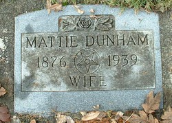
Mattie Berry Dunham
| Birth | : | 2 Sep 1876 Russellville, Cole County, Missouri, USA |
| Death | : | 8 Jan 1939 Shelton, Mason County, Washington, USA |
| Burial | : | Old St Mary's Churchyard, Walmer, Dover District, England |
| Coordinate | : | 51.2032261, 1.3870063 |
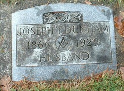
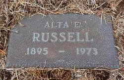
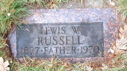
| Description | : | First marriage Allen Russell Mrs. Dunham Dies After Long Illness Mrs. Mattie Dunham, a resident of Shelton for the last nine years, died Sunday at her home at 320 Laurel following an illness of several years. She was 62 years old. Services were held this afternoon at the Masonic Temple with Eleanor chapter O.E.S., Union City in charge. She was interned beside her husband in the Masonic Cemetery. Mr. Dunham died in 1929. Mrs. Dunham was born in Russellville, Mo., September 2, 1876, and came to this area in 1918. She was a Past Matron on the Order of Eastern Star, Eleanor chapter. Surviving are her... Read More |
frequently asked questions (FAQ):
-
Where is Mattie Berry Dunham's memorial?
Mattie Berry Dunham's memorial is located at: Old St Mary's Churchyard, Walmer, Dover District, England.
-
When did Mattie Berry Dunham death?
Mattie Berry Dunham death on 8 Jan 1939 in Shelton, Mason County, Washington, USA
-
Where are the coordinates of the Mattie Berry Dunham's memorial?
Latitude: 51.2032261
Longitude: 1.3870063
Family Members:
Parent
Spouse
Siblings
Children
Flowers:


Nearby Cemetories:
1. Old St Mary's Churchyard
Walmer, Dover District, England
Coordinate: 51.2032261, 1.3870063
2. Hamilton Road Cemetery
Deal, Dover District, England
Coordinate: 51.2140870, 1.3923380
3. St Leonard Churchyard
Deal, Dover District, England
Coordinate: 51.2169940, 1.3817700
4. St Mary the Virgin Churchyard
Ripple, Dover District, England
Coordinate: 51.2027080, 1.3629570
5. St. Nicholas Churchyard
Sholden, Dover District, England
Coordinate: 51.2198600, 1.3769300
6. St. Nicholas' Churchyard
Ringwould, Dover District, England
Coordinate: 51.1853300, 1.3754880
7. St John the Evangelist Churchyard
Deal, Dover District, England
Coordinate: 51.1862200, 1.4016700
8. St John Churchyard
Kingsdown, Dover District, England
Coordinate: 51.1860700, 1.4023200
9. St Martin Churchyard
Great Mongeham, Dover District, England
Coordinate: 51.2145160, 1.3581010
10. Deal Congregational Church
Deal, Dover District, England
Coordinate: 51.2264163, 1.4024282
11. St. Peter and St. Paul Churchyard
Sutton, Dover District, England
Coordinate: 51.1955800, 1.3397700
12. St Augustine Churchyard
Northbourne, Dover District, England
Coordinate: 51.2221700, 1.3403500
13. St Augustine's Church
East Langdon, Dover District, England
Coordinate: 51.1654990, 1.3357270
14. St. Margaret of Antioch Churchyard
St Margarets at Cliffe, Dover District, England
Coordinate: 51.1534950, 1.3714350
15. St Mary the Virgin Churchyard
Betteshanger, Dover District, England
Coordinate: 51.2251200, 1.3118800
16. Saint Peters Church
Westcliffe, Dover District, England
Coordinate: 51.1542430, 1.3573340
17. Church of Saint George at Ham
Eastry, Dover District, England
Coordinate: 51.2444830, 1.3319350
18. Saint Andrew Churchyard
Tilmanstone, Dover District, England
Coordinate: 51.2159790, 1.2950400
19. St Mary the Virgin Churchyard
Eastry, Dover District, England
Coordinate: 51.2453000, 1.3100000
20. St Peter Churchyard
Whitfield, Dover District, England
Coordinate: 51.1655000, 1.3037000
21. All Saints Churchyard
Waldershare, Dover District, England
Coordinate: 51.1875170, 1.2857870
22. St Clement's Church
Sandwich, Dover District, England
Coordinate: 51.2736510, 1.3427270
23. Eythorne Baptist Church Cemetery
Eythorne, Dover District, England
Coordinate: 51.1982330, 1.2661470
24. St. Peter's Churchyard
Sandwich, Dover District, England
Coordinate: 51.2747680, 1.3405120