
| Birth | : | 19 Dec 1897 Wakefield, Clay County, Kansas, USA |
| Death | : | 14 Aug 1929 Wamego, Pottawatomie County, Kansas, USA |
| Burial | : | Harris Cemetery, Barada, Richardson County, USA |
| Coordinate | : | 40.2182999, -95.5730972 |
| Plot | : | Addition 1, Block 20, Section O, Lot 12. Cemetery office confirmed that this burial is unmarked. |
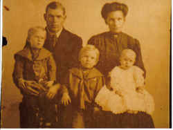
| Description | : | Wamego Reporter Wamego, Kansas 15 August 1929 Killed on No. 40 ---------- Michael Matthew Harrison of Kansas City Killed When Nash Caoch Turns Over --------- Wednesday morning at about 6:45 o'clock M.M. Harrison of Kansas City was dirving his Nash coach west on No. 40, east of Wamego. In the car was his wife, Mrs. Alice Harrison and son, Robert Lee Harrison and his sister, Mrs. Jennie Sonnenberg. The Harrisons lived at 1209 Benton Boulevard and Mes. Sonnenberg at 1800 Summit, Kansas City, Mo. They were on their way to visit Mr. Harrison's mother who is ill at Clay Center. Frank Doughan, on his way to Belvue,... Read More |
frequently asked questions (FAQ):
-
Where is Michael Matthew Harrison's memorial?
Michael Matthew Harrison's memorial is located at: Harris Cemetery, Barada, Richardson County, USA.
-
When did Michael Matthew Harrison death?
Michael Matthew Harrison death on 14 Aug 1929 in Wamego, Pottawatomie County, Kansas, USA
-
Where are the coordinates of the Michael Matthew Harrison's memorial?
Latitude: 40.2182999
Longitude: -95.5730972
Family Members:
Parent

Siblings
Flowers:


Nearby Cemetories:
1. Harris Cemetery
Barada, Richardson County, USA
Coordinate: 40.2182999, -95.5730972
2. Saint Johns Catholic Cemetery
Barada, Richardson County, USA
Coordinate: 40.2189000, -95.5683000
3. Berg Cemetery
Barada, Richardson County, USA
Coordinate: 40.2257996, -95.6168976
4. Brick Church Cemetery
Barada, Richardson County, USA
Coordinate: 40.2328000, -95.6155000
5. Saint Deroin Cemetery
Barada, Richardson County, USA
Coordinate: 40.2543983, -95.5682983
6. Huff Cemetery
Barada, Richardson County, USA
Coordinate: 40.2039000, -95.6248500
7. Saint Peters Evangelical Lutheran Church Cemetery
Richardson County, USA
Coordinate: 40.1752014, -95.5491257
8. Half-Breed Cemetery
Nemaha County, USA
Coordinate: 40.2664900, -95.5604900
9. Saint Annes Catholic Cemetery
Shubert, Richardson County, USA
Coordinate: 40.2042500, -95.6549500
10. Fricke Cemetery
Richardson County, USA
Coordinate: 40.1516991, -95.5391998
11. Hillsdale Cemetery
Nemaha County, USA
Coordinate: 40.2882996, -95.6010971
12. Saint Pauls Evangelical Lutheran Cemetery
Falls City, Richardson County, USA
Coordinate: 40.1443800, -95.6150400
13. Saint Johns Cemetery
Richardson County, USA
Coordinate: 40.1375008, -95.5188980
14. Anderson Cemetery
Barada, Richardson County, USA
Coordinate: 40.1612200, -95.4771200
15. Arago Cemetery
Richardson County, USA
Coordinate: 40.1519012, -95.4728012
16. Maple Grove Cemetery
Verdon, Richardson County, USA
Coordinate: 40.1307983, -95.6410980
17. Silver Creek Cemetery
Richardson County, USA
Coordinate: 40.1157990, -95.5969009
18. Penniwell Cemetery
Shubert, Richardson County, USA
Coordinate: 40.2619000, -95.6994500
19. Mount Hope Cemetery
Atchison County, USA
Coordinate: 40.2696991, -95.4503021
20. Cupola Cemetery
Verdon, Richardson County, USA
Coordinate: 40.1892014, -95.7086029
21. Prairie Union Cemetery
Shubert, Richardson County, USA
Coordinate: 40.2475800, -95.7150200
22. Verdon Cemetery
Verdon, Richardson County, USA
Coordinate: 40.1450005, -95.6893997
23. Archer Cemetery
Falls City, Richardson County, USA
Coordinate: 40.0950200, -95.5736900
24. Saint Marks Lutheran Cemetery
Verdon, Richardson County, USA
Coordinate: 40.1160100, -95.6864900