
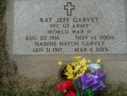
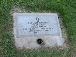
Nadine Arlette Hatch Garvey
| Birth | : | 31 Jan 1917 Auburn, Placer County, California, USA |
| Death | : | 6 Mar 2013 Chico, Butte County, California, USA |
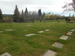
| Burial | : | Old Auburn Cemetery, Auburn, Placer County, USA |
| Coordinate | : | 38.9023720, -121.0812230 |
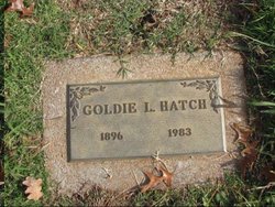
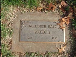
| Description | : | Nadine was the eldest daughter of Charles William and Goldie Lucille (nee Branch) Hatch. She attended Auburn High School and Placer Junior College. During World War II, she worked as a supervisor for AT&T. On April 26, 1947, she married Ray "Jeff" Garvey. In 1953, they moved to West Sacramento where they raised their two daughters. Nadine enjoyed genealogy, camping, gardening, craft projects, and made amazing lemon meringue pies. She was predeceased by her parents; her sister, Charlotte Murch; and her husband. Nadine was survived by her daughters, Barbara Benge and Kathleen McFarren, as well as five grandchildren and one... Read More |
frequently asked questions (FAQ):
-
Where is Nadine Arlette Hatch Garvey's memorial?
Nadine Arlette Hatch Garvey's memorial is located at: Old Auburn Cemetery, Auburn, Placer County, USA.
-
When did Nadine Arlette Hatch Garvey death?
Nadine Arlette Hatch Garvey death on 6 Mar 2013 in Chico, Butte County, California, USA
-
Where are the coordinates of the Nadine Arlette Hatch Garvey's memorial?
Latitude: 38.9023720
Longitude: -121.0812230
Family Members:
Parent
Spouse

Siblings
Flowers:


Nearby Cemetories:
1. Old Auburn Cemetery
Auburn, Placer County, USA
Coordinate: 38.9023720, -121.0812230
2. New Auburn Cemetery
Auburn, Placer County, USA
Coordinate: 38.9026900, -121.0870800
3. Placer County Hospital Cemetery
Auburn, Placer County, USA
Coordinate: 38.9045120, -121.0721320
4. Clark Ashton Smith Gravesite
Auburn, Placer County, USA
Coordinate: 38.8952100, -121.0770500
5. Bethlehem Lutheran Church Columbarium
Auburn, Placer County, USA
Coordinate: 38.8932350, -121.0749690
6. First Congregational Church Memorial Garden
Auburn, Placer County, USA
Coordinate: 38.9118660, -121.0711770
7. Chinese Cemetery
Auburn, Placer County, USA
Coordinate: 38.9183502, -121.0802383
8. Maidu Indian Burial Grounds
Auburn, Placer County, USA
Coordinate: 38.8744350, -121.0777290
9. Ophir Cemetery
Placer County, USA
Coordinate: 38.8928870, -121.1273790
10. Newcastle Cemetery
Newcastle, Placer County, USA
Coordinate: 38.8708880, -121.1444060
11. Wells Cemetery
Auburn, Placer County, USA
Coordinate: 38.9667000, -121.1054900
12. Gold Hill Cemetery
Gold Hill, Placer County, USA
Coordinate: 38.9025000, -121.1802200
13. Bayley Family Cemetery
Pilot Hill, El Dorado County, USA
Coordinate: 38.8438800, -121.0148900
14. Stewarts Flat Cemetery
Penryn, Placer County, USA
Coordinate: 38.8447360, -121.1507950
15. Lone Star Cemetery
Placer County, USA
Coordinate: 38.9757996, -121.1380997
16. Rattlesnake Bar Graveyard
Auburn, Placer County, USA
Coordinate: 38.8163050, -121.0895100
17. Clipper Gap Cemetery
Clipper Gap, Placer County, USA
Coordinate: 38.9784880, -121.0256590
18. Pilot Hill Cemetery
Pilot Hill, El Dorado County, USA
Coordinate: 38.8301010, -121.0093307
19. Mansur Family Cemetery
Loomis, Placer County, USA
Coordinate: 38.8139600, -121.1214000
20. Prosser Family Cemetery
Loomis, Placer County, USA
Coordinate: 38.8071900, -121.1285600
21. Esoteric Fraternity Cemetery
Applegate, Placer County, USA
Coordinate: 38.9946190, -120.9687490
22. Georgetown-Renke Cemetery Annex
Georgetown, El Dorado County, USA
Coordinate: 38.8964610, -120.9116240
23. Greenwood Pioneer Cemetery
Greenwood, El Dorado County, USA
Coordinate: 38.8985786, -120.9099274
24. Spanish Dry Diggings Cemetery
Greenwood, El Dorado County, USA
Coordinate: 38.9431600, -120.9158000