
| Memorials | : | 0 |
| Location | : | Applegate, Placer County, USA |
| Coordinate | : | 38.9946190, -120.9687490 |
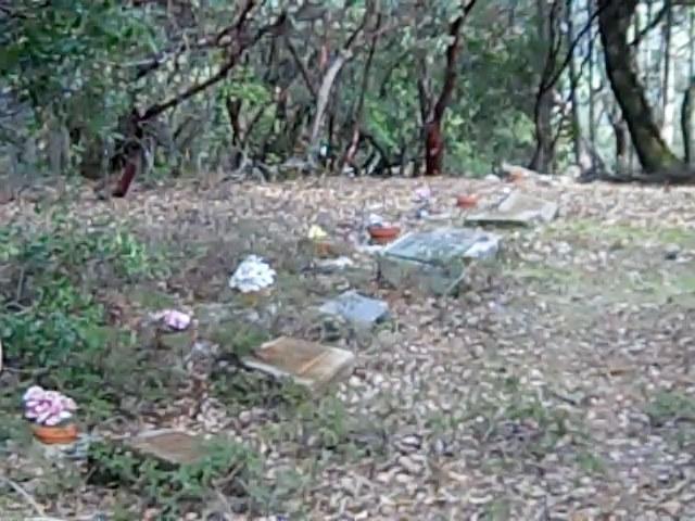
| Description | : | Private property, permission is needed to enter. Forty miles northeast of Sacramento, off I-80 near the village of Applegate, stand the remains of one of Northern California's oddest religious cults: the Esoteric Fraternity. Founded in 1887, the Fraternity pioneered modern astrology, prepared its followers to run a worldwide religious dictatorship, and faded from history after a still-unsolved murder claimed one of its members. The Esoteric Fraternity was founded by metaphysical scholar and author Hiram Erastus Butler. In 1891, Butler took twelve followers from Boston to Applegate, California, and settled on a 500-acre homestead overlooking the American River. There, they... Read More |
frequently asked questions (FAQ):
-
Where is Esoteric Fraternity Cemetery?
Esoteric Fraternity Cemetery is located at Applegate, Placer County ,California ,USA.
-
Esoteric Fraternity Cemetery cemetery's updated grave count on graveviews.com?
0 memorials
-
Where are the coordinates of the Esoteric Fraternity Cemetery?
Latitude: 38.9946190
Longitude: -120.9687490
Nearby Cemetories:
1. Weimar Sanatorium Cemetery
Weimar, Placer County, USA
Coordinate: 39.0350200, -120.9834400
2. Clipper Gap Cemetery
Clipper Gap, Placer County, USA
Coordinate: 38.9784880, -121.0256590
3. Spring Garden Indian Cemetery
Foresthill, Placer County, USA
Coordinate: 38.9998620, -120.9049310
4. Spanish Dry Diggings Cemetery
Greenwood, El Dorado County, USA
Coordinate: 38.9431600, -120.9158000
5. Todd Valley Cemetery
Placer County, USA
Coordinate: 38.9970900, -120.8541000
6. Yankee Jims Cemetery
Foresthill, Placer County, USA
Coordinate: 39.0292511, -120.8614349
7. Colfax Indian Cemetery
Colfax, Placer County, USA
Coordinate: 39.0909900, -120.9503000
8. Colfax Cemetery
Colfax, Placer County, USA
Coordinate: 39.0979522, -120.9471644
9. Greenwood Pioneer Cemetery
Greenwood, El Dorado County, USA
Coordinate: 38.8985786, -120.9099274
10. Georgetown-Renke Cemetery Annex
Georgetown, El Dorado County, USA
Coordinate: 38.8964610, -120.9116240
11. Wells Cemetery
Auburn, Placer County, USA
Coordinate: 38.9667000, -121.1054900
12. First Congregational Church Memorial Garden
Auburn, Placer County, USA
Coordinate: 38.9118660, -121.0711770
13. Chinese Cemetery
Auburn, Placer County, USA
Coordinate: 38.9183502, -121.0802383
14. Placer County Hospital Cemetery
Auburn, Placer County, USA
Coordinate: 38.9045120, -121.0721320
15. Foresthill Community Cemetery
Foresthill, Placer County, USA
Coordinate: 39.0184500, -120.8114700
16. Georgia Slide Cemetery
Georgetown, El Dorado County, USA
Coordinate: 38.9218063, -120.8377838
17. Old Auburn Cemetery
Auburn, Placer County, USA
Coordinate: 38.9023720, -121.0812230
18. Saint Joseph Catholic Cemetery
Foresthill, Placer County, USA
Coordinate: 39.0240200, -120.8068800
19. New Auburn Cemetery
Auburn, Placer County, USA
Coordinate: 38.9026900, -121.0870800
20. Clark Ashton Smith Gravesite
Auburn, Placer County, USA
Coordinate: 38.8952100, -121.0770500
21. Bethlehem Lutheran Church Columbarium
Auburn, Placer County, USA
Coordinate: 38.8932350, -121.0749690
22. Georgetown Pioneer Cemetery
Georgetown, El Dorado County, USA
Coordinate: 38.9068108, -120.8430862
23. Lone Star Cemetery
Placer County, USA
Coordinate: 38.9757996, -121.1380997
24. Carmelite Monastery Cemetery
Georgetown, El Dorado County, USA
Coordinate: 38.9273300, -120.8173840