
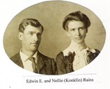

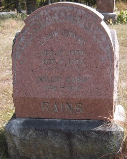
Nellie Konklin Rains
| Birth | : | 24 May 1874 High Point, Decatur County, Iowa, USA |
| Death | : | 31 Jan 1935 Garden Grove, Decatur County, Iowa, USA |
| Burial | : | St. Michael’s Churchyard, St Michael's on Wyre, Wyre Borough, England |
| Coordinate | : | 53.8628050, -2.8195430 |
| Plot | : | R4, DS1 |
| Description | : | Parents: GEORGE ADAM KONKLIN & MARTHA ANN PERDUE. Siblings: ALBERT, JOHN ADAM, LAWRENCE, OLIVE, GEORGE F., JAMES W., ELLA MARIE (MRS. WILLIAM 'CLAUDE' BEAVERS), THOMAS R. 'DOLPH', MARTHA ANN 'MATTIE' (MRS. TED ALBERT CULVER), ESTELLA 'STELLA' (MRS. C. S. SWANSON). Children: None surviving. |
frequently asked questions (FAQ):
-
Where is Nellie Konklin Rains's memorial?
Nellie Konklin Rains's memorial is located at: St. Michael’s Churchyard, St Michael's on Wyre, Wyre Borough, England.
-
When did Nellie Konklin Rains death?
Nellie Konklin Rains death on 31 Jan 1935 in Garden Grove, Decatur County, Iowa, USA
-
Where are the coordinates of the Nellie Konklin Rains's memorial?
Latitude: 53.8628050
Longitude: -2.8195430
Family Members:
Parent

Spouse
Flowers:


Nearby Cemetories:
1. St. Michael’s Churchyard
St Michael's on Wyre, Wyre Borough, England
Coordinate: 53.8628050, -2.8195430
2. St. Helen's Churchyard
Kirkland (Churchtown), Wyre Borough, England
Coordinate: 53.8790700, -2.7901000
3. St. Peters Churchyard
Inskip with Sowerby, Wyre Borough, England
Coordinate: 53.8347100, -2.8175200
4. Inskip Baptist Churchyard
Inskip with Sowerby, Wyre Borough, England
Coordinate: 53.8353150, -2.8299610
5. St Mary Roman Catholic Churchyard
Great Eccleston, Wyre Borough, England
Coordinate: 53.8535420, -2.8710090
6. Kirkland Strict and Particular Baptist Chapel
Nateby, Wyre Borough, England
Coordinate: 53.8961210, -2.8170130
7. St Anne Churchyard
Great Eccleston, Wyre Borough, England
Coordinate: 53.8481413, -2.8835925
8. Elswick Congregational Chapelyard
Elswick, Fylde Borough, England
Coordinate: 53.8378950, -2.8775320
9. St. Thomas Churchyard
Garstang, Wyre Borough, England
Coordinate: 53.8992300, -2.7764500
10. St Mary and St Michael Catholic Churchyard
Garstang, Wyre Borough, England
Coordinate: 53.8975610, -2.7706170
11. St. John’s Churchyard
Out Rawcliffe, Wyre Borough, England
Coordinate: 53.8741650, -2.8959310
12. St. Hilda's Churchyard
Bilsborrow, Wyre Borough, England
Coordinate: 53.8522170, -2.7420090
13. Garstang United Reformed Churchyard
Garstang, Wyre Borough, England
Coordinate: 53.9026500, -2.7747400
14. St. Lawrence Churchyard
Barton, City of Preston, England
Coordinate: 53.8289213, -2.7366654
15. Christ Churchyard
Treales, Fylde Borough, England
Coordinate: 53.8045970, -2.8440710
16. St Thomas Churchyard
Claughton-on-Brock, Wyre Borough, England
Coordinate: 53.8752030, -2.7199160
17. St Mary's Newhouse
Barton, City of Preston, England
Coordinate: 53.8205240, -2.7406500
18. All Saints Parish Churchyard
Barnacre with Bonds, Wyre Borough, England
Coordinate: 53.9079120, -2.7430580
19. Saint Anne's Church
Woodplumpton, City of Preston, England
Coordinate: 53.8038130, -2.7621940
20. St Anne Churchyard
Singleton, Fylde Borough, England
Coordinate: 53.8379280, -2.9359890
21. St. Anne's Churchyard
Blackburn, Blackburn with Darwen Unitary Authority, England
Coordinate: 53.8381160, -2.9362870
22. St William of York Church
Pilling, Wyre Borough, England
Coordinate: 53.9235047, -2.8934617
23. St. Peter's Churchyard
Garstang, Wyre Borough, England
Coordinate: 53.9309510, -2.7591190
24. Saint Joseph's Roman Catholic Church
Wesham, Fylde Borough, England
Coordinate: 53.7928600, -2.8871800