
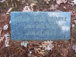
Nellie Maria Page Clarke
| Birth | : | 26 May 1888 Connecticut, USA |
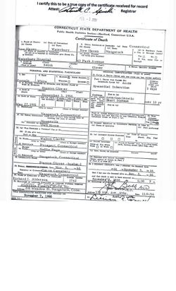
| Death | : | 19 Jan 1935 Naugatuck, New Haven County, Connecticut, USA |
| Burial | : | North Sandwich Cemetery, North Sandwich, Carroll County, USA |
| Coordinate | : | 43.8410750, -71.3953610 |
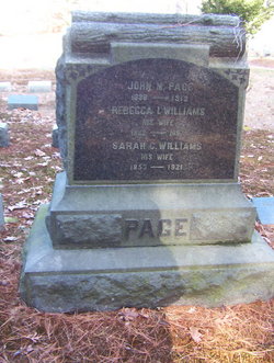
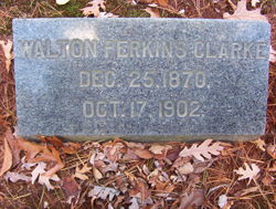
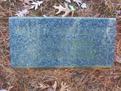
| Description | : | Nellie Maria Page was born to John M. Page on May 26, 1868 in Connecticut. She married Walton Perkins *Clark on July 12, 1898 in Naugatuck, New Haven County, Connecticut. Nellie died on January 19, 1935 in Naugatuck at age 66 years, 7 months, and 24 days old. Walton and Nellie had two children, Walton Page Clark and Edith Clark. *(NOTE) An ‘e’ was added to the end of her married surname, Clark in the US 1910 & 1920 Census. The first appearance of the surname being spelled as Clarke in this family group was on the headstone of her sister-in-law, Edith May... Read More |
frequently asked questions (FAQ):
-
Where is Nellie Maria Page Clarke's memorial?
Nellie Maria Page Clarke's memorial is located at: North Sandwich Cemetery, North Sandwich, Carroll County, USA.
-
When did Nellie Maria Page Clarke death?
Nellie Maria Page Clarke death on 19 Jan 1935 in Naugatuck, New Haven County, Connecticut, USA
-
Where are the coordinates of the Nellie Maria Page Clarke's memorial?
Latitude: 43.8410750
Longitude: -71.3953610
Family Members:
Parent

Spouse
Siblings

Children
Flowers:


Nearby Cemetories:
1. North Sandwich Cemetery
North Sandwich, Carroll County, USA
Coordinate: 43.8410750, -71.3953610
2. Quinby Cemetery
North Sandwich, Carroll County, USA
Coordinate: 43.8433000, -71.4148000
3. Weed Cemetery
North Sandwich, Carroll County, USA
Coordinate: 43.8567140, -71.3907470
4. Morse Cemetery
Center Sandwich, Carroll County, USA
Coordinate: 43.8534300, -71.4241600
5. Weeds Mills Cemetery
North Sandwich, Carroll County, USA
Coordinate: 43.8678460, -71.3950260
6. G.G. Smith Cemetery
North Sandwich, Carroll County, USA
Coordinate: 43.8390666, -71.3548476
7. North Sandwich Friends Cemetery
North Sandwich, Carroll County, USA
Coordinate: 43.8607300, -71.3636400
8. Mason Cemetery
North Sandwich, Carroll County, USA
Coordinate: 43.8542000, -71.4426000
9. Elm Hill Cemetery
Center Sandwich, Carroll County, USA
Coordinate: 43.8158000, -71.4336000
10. Elm Hill Cemetery
Sandwich, Carroll County, USA
Coordinate: 43.8158330, -71.4338890
11. Stevenson Cemetery
Tamworth, Carroll County, USA
Coordinate: 43.8471985, -71.3431015
12. Vittum Hill Cemetery
Sandwich, Carroll County, USA
Coordinate: 43.8096700, -71.3578100
13. Wallace-Vittum Cemetery
Sandwich, Carroll County, USA
Coordinate: 43.8110897, -71.3536102
14. Beede Cemetery
Sandwich, Carroll County, USA
Coordinate: 43.8013890, -71.4166670
15. Baptist Burial Ground
Center Sandwich, Carroll County, USA
Coordinate: 43.8079900, -71.4392600
16. Grove Cemetery
Sandwich, Carroll County, USA
Coordinate: 43.8101100, -71.4445200
17. Cemetery of the Religious Society of Friends
Sandwich, Carroll County, USA
Coordinate: 43.7994400, -71.4266700
18. Mears-Nelson Cemetery
Sandwich, Carroll County, USA
Coordinate: 43.7932790, -71.3820560
19. Cram-Webster Cemetery
Sandwich, Carroll County, USA
Coordinate: 43.7972220, -71.3641670
20. Littles Pond Cemetery
Sandwich, Carroll County, USA
Coordinate: 43.7915600, -71.4034200
21. Whiteface Intervale Cemetery
Sandwich, Carroll County, USA
Coordinate: 43.8911000, -71.3998000
22. Meader Cemetery
Tamworth, Carroll County, USA
Coordinate: 43.8387880, -71.3242646
23. Pease Cemetery
Tamworth, Carroll County, USA
Coordinate: 43.8782000, -71.3413000
24. Nathanial Fry Family Plot
Sandwich, Carroll County, USA
Coordinate: 43.7875872, -71.3844592