
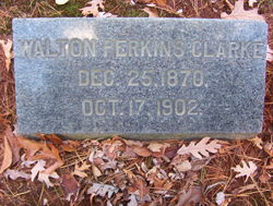
Walton Perkins Clarke
| Birth | : | 25 Dec 1870 Prospect, New Haven County, Connecticut, USA |
| Death | : | 17 Oct 1902 Naugatuck, New Haven County, Connecticut, USA |
| Burial | : | North Sandwich Cemetery, North Sandwich, Carroll County, USA |
| Coordinate | : | 43.8410750, -71.3953610 |
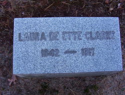
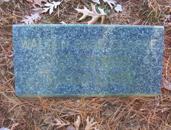
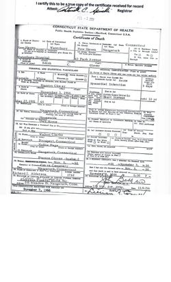
| Description | : | Walton Perkins *Clark was born to Horatio Nelson Clark and Laura DeEtte (Perkins) Clark on December 25, 1870 in Prospect, New Haven County, Connecticut. He married Nellie Maria Page on July 12, 1898 in Naugatuck, New Haven County, Connecticut. He worked in a rubber shop. Walton died on October 17, 1902 in Naugatuck at age 31 years, 9 months, and 22 days old. He was buried in Grove Cemetery in Naugatuck. Walton and Nellie had two children, Walton Page Clark and Edith Clarke. *(NOTE) An ‘e’ was added to the end of his surname on... Read More |
frequently asked questions (FAQ):
-
Where is Walton Perkins Clarke's memorial?
Walton Perkins Clarke's memorial is located at: North Sandwich Cemetery, North Sandwich, Carroll County, USA.
-
When did Walton Perkins Clarke death?
Walton Perkins Clarke death on 17 Oct 1902 in Naugatuck, New Haven County, Connecticut, USA
-
Where are the coordinates of the Walton Perkins Clarke's memorial?
Latitude: 43.8410750
Longitude: -71.3953610
Family Members:
Parent

Spouse
Siblings
Children
Flowers:


Nearby Cemetories:
1. North Sandwich Cemetery
North Sandwich, Carroll County, USA
Coordinate: 43.8410750, -71.3953610
2. Quinby Cemetery
North Sandwich, Carroll County, USA
Coordinate: 43.8433000, -71.4148000
3. Weed Cemetery
North Sandwich, Carroll County, USA
Coordinate: 43.8567140, -71.3907470
4. Morse Cemetery
Center Sandwich, Carroll County, USA
Coordinate: 43.8534300, -71.4241600
5. Weeds Mills Cemetery
North Sandwich, Carroll County, USA
Coordinate: 43.8678460, -71.3950260
6. G.G. Smith Cemetery
North Sandwich, Carroll County, USA
Coordinate: 43.8390666, -71.3548476
7. North Sandwich Friends Cemetery
North Sandwich, Carroll County, USA
Coordinate: 43.8607300, -71.3636400
8. Mason Cemetery
North Sandwich, Carroll County, USA
Coordinate: 43.8542000, -71.4426000
9. Elm Hill Cemetery
Center Sandwich, Carroll County, USA
Coordinate: 43.8158000, -71.4336000
10. Elm Hill Cemetery
Sandwich, Carroll County, USA
Coordinate: 43.8158330, -71.4338890
11. Stevenson Cemetery
Tamworth, Carroll County, USA
Coordinate: 43.8471985, -71.3431015
12. Vittum Hill Cemetery
Sandwich, Carroll County, USA
Coordinate: 43.8096700, -71.3578100
13. Wallace-Vittum Cemetery
Sandwich, Carroll County, USA
Coordinate: 43.8110897, -71.3536102
14. Beede Cemetery
Sandwich, Carroll County, USA
Coordinate: 43.8013890, -71.4166670
15. Baptist Burial Ground
Center Sandwich, Carroll County, USA
Coordinate: 43.8079900, -71.4392600
16. Grove Cemetery
Sandwich, Carroll County, USA
Coordinate: 43.8101100, -71.4445200
17. Cemetery of the Religious Society of Friends
Sandwich, Carroll County, USA
Coordinate: 43.7994400, -71.4266700
18. Mears-Nelson Cemetery
Sandwich, Carroll County, USA
Coordinate: 43.7932790, -71.3820560
19. Cram-Webster Cemetery
Sandwich, Carroll County, USA
Coordinate: 43.7972220, -71.3641670
20. Littles Pond Cemetery
Sandwich, Carroll County, USA
Coordinate: 43.7915600, -71.4034200
21. Whiteface Intervale Cemetery
Sandwich, Carroll County, USA
Coordinate: 43.8911000, -71.3998000
22. Meader Cemetery
Tamworth, Carroll County, USA
Coordinate: 43.8387880, -71.3242646
23. Pease Cemetery
Tamworth, Carroll County, USA
Coordinate: 43.8782000, -71.3413000
24. Nathanial Fry Family Plot
Sandwich, Carroll County, USA
Coordinate: 43.7875872, -71.3844592