
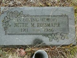
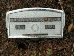

Nettie May Shultz Rossmaier
| Birth | : | 30 Jun 1911 Tenino, Thurston County, Washington, USA |
| Death | : | 30 Mar 1986 Olympia, Thurston County, Washington, USA |
| Burial | : | St. Peter and St. Paul Churchyard, Shiplake, South Oxfordshire District, England |
| Coordinate | : | 51.4980750, -0.8963940 |
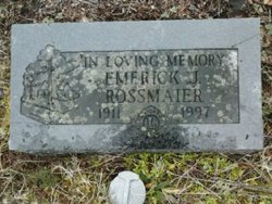
| Description | : | Nettie M. Rossmaier, 74, a life resident of Tenino, died Sunday, March 30, 1986 in St. Peter Hospital, Olympia, after a lengthy illness. She was born June 30, 1911 in Tenino. She is survived by her husband Emerick J., one daughter, and one brother, Jim Shultz, all of Tenino; and numerous nieces and nephews. The graveside service for Mrs. Rossmaier will begin at 3 p.m. Wednesday, April 2, in Forest Grove Cemetery, Tenino, with the Rev. Ron Rice officiating. Arrangements are under the direction of Newell-Hoerling's Chapel, Centralia. |
frequently asked questions (FAQ):
-
Where is Nettie May Shultz Rossmaier's memorial?
Nettie May Shultz Rossmaier's memorial is located at: St. Peter and St. Paul Churchyard, Shiplake, South Oxfordshire District, England.
-
When did Nettie May Shultz Rossmaier death?
Nettie May Shultz Rossmaier death on 30 Mar 1986 in Olympia, Thurston County, Washington, USA
-
Where are the coordinates of the Nettie May Shultz Rossmaier's memorial?
Latitude: 51.4980750
Longitude: -0.8963940
Family Members:
Parent
Spouse
Siblings
Flowers:


Nearby Cemetories:
1. St. Peter and St. Paul Churchyard
Shiplake, South Oxfordshire District, England
Coordinate: 51.4980750, -0.8963940
2. St. Mary's Churchyard
Wargrave, Wokingham Borough, England
Coordinate: 51.4998329, -0.8735808
3. St Margaret's Churchyard
Harpsden, South Oxfordshire District, England
Coordinate: 51.5219160, -0.9012270
4. St. Andrew's Churchyard
Sonning, Wokingham Borough, England
Coordinate: 51.4740300, -0.9131640
5. St Mary's Churchyard
Twyford, Wokingham Borough, England
Coordinate: 51.4763850, -0.8673190
6. All Saints Churchyard
Dunsden Green, South Oxfordshire District, England
Coordinate: 51.4917730, -0.9461650
7. Holy Trinity Churchyard
Henley-on-Thames, South Oxfordshire District, England
Coordinate: 51.5338500, -0.9066600
8. Christ Church
Henley-on-Thames, South Oxfordshire District, England
Coordinate: 51.5347880, -0.9032820
9. St. Mary the Virgin Churchyard
Henley-on-Thames, South Oxfordshire District, England
Coordinate: 51.5377790, -0.9017520
10. Reading Cemetery and Crematorium
Caversham, Reading Borough, England
Coordinate: 51.4737690, -0.9546570
11. St. Nicholas' Churchyard
Rotherfield Greys, South Oxfordshire District, England
Coordinate: 51.5351017, -0.9541395
12. St. Peter's Churchyard
Knowl Hill, Windsor and Maidenhead Royal Borough, England
Coordinate: 51.5093351, -0.8126725
13. Caversham Cemetery
Caversham, Reading Borough, England
Coordinate: 51.4745850, -0.9758020
14. Reading Cemetery
Reading, Reading Borough, England
Coordinate: 51.4529450, -0.9480160
15. All Saints Churchyard
Rotherfield Peppard, South Oxfordshire District, England
Coordinate: 51.5280531, -0.9725009
16. St Lawrence Churchyard
Waltham St Lawrence, Windsor and Maidenhead Royal Borough, England
Coordinate: 51.4856000, -0.8066600
17. Mays Lane Burial Ground
Earley, Wokingham Borough, England
Coordinate: 51.4431680, -0.9240020
18. Earley St Peter Churchyard
Earley, Wokingham Borough, England
Coordinate: 51.4434820, -0.9290850
19. Reading Prison Cemetery
Reading, Reading Borough, England
Coordinate: 51.4564910, -0.9641120
20. Henley-on-Thames Cemetery
Henley-on-Thames, South Oxfordshire District, England
Coordinate: 51.5543570, -0.9271320
21. Reading Abbey Ruins
Reading, Reading Borough, England
Coordinate: 51.4563710, -0.9651130
22. St. Peter's Churchyard
Caversham, Reading Borough, England
Coordinate: 51.4686597, -0.9807669
23. St. Laurence Churchyard
Reading, Reading Borough, England
Coordinate: 51.4567474, -0.9686236
24. Kidmore End Cemetery
Kidmore End, South Oxfordshire District, England
Coordinate: 51.5071600, -0.9942160