
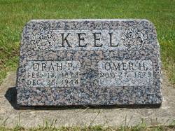
Omer H Keel
| Birth | : | 27 Nov 1873 |
| Death | : | 19 Jul 1950 |
| Burial | : | Rose Hill Memorial Gardens, Missouri Valley, Harrison County, USA |
| Coordinate | : | 41.5656000, -95.8897000 |
| Plot | : | Section 10, Row 7 |
| Description | : | Published in The Rochester News-Sentinel Wednesday, July 19, 1950 Omer Keel Omer KEEL died early this afternoon at his home east of Woodrow school. The bod was taken to the Foster funeral home where final rites are pending. ----- Published in The Rochester News-Sentinel Thursday, July 20, 1950 Omer Keel Funeral services for Omer H. KEEL, 77, who died Wednesday at his farm home three miles southeast of here, will be held at 2 p.m. Saturday at the Foster Funeral Home. Burial will be in the IOOF cemetery. Born Nov. 27, 1873, he was the son of Thomas and Sarah Ann KEEL and was a lifelong resident of Fulton... Read More |
frequently asked questions (FAQ):
-
Where is Omer H Keel's memorial?
Omer H Keel's memorial is located at: Rose Hill Memorial Gardens, Missouri Valley, Harrison County, USA.
-
When did Omer H Keel death?
Omer H Keel death on 19 Jul 1950 in
-
Where are the coordinates of the Omer H Keel's memorial?
Latitude: 41.5656000
Longitude: -95.8897000
Family Members:
Parent

Spouse

Siblings
Children

Flowers:


Nearby Cemetories:
1. Rose Hill Memorial Gardens
Missouri Valley, Harrison County, USA
Coordinate: 41.5656000, -95.8897000
2. Mount Carmel Cemetery
Missouri Valley, Harrison County, USA
Coordinate: 41.5675011, -95.8897018
3. Champan Frazier Cemetery
Harrison County, USA
Coordinate: 41.5773500, -95.8933500
4. Hurleys Evergreen Cemetery
Harrison County, USA
Coordinate: 41.5700989, -95.8618698
5. Frazier Cemetery
Missouri Valley, Harrison County, USA
Coordinate: 41.5932999, -95.8375015
6. Oak Grove Cemetery
Missouri Valley, Harrison County, USA
Coordinate: 41.5167007, -95.8649979
7. Calhoun Cemetery
Calhoun, Harrison County, USA
Coordinate: 41.6391983, -95.8938980
8. Branson Cemetery
Loveland, Pottawattamie County, USA
Coordinate: 41.4846992, -95.8606033
9. Linnwood Cemetery
Harrison County, USA
Coordinate: 41.5589200, -95.7502100
10. Crook Cemetery
Honey Creek, Pottawattamie County, USA
Coordinate: 41.4581330, -95.8737000
11. Saint Bridgets Cemetery
Honey Creek, Pottawattamie County, USA
Coordinate: 41.4664001, -95.8289032
12. Logan Cemetery
Logan, Harrison County, USA
Coordinate: 41.6487579, -95.7843170
13. Harris Grove Cemetery
Beebeetown, Harrison County, USA
Coordinate: 41.5782928, -95.7262192
14. Magnolia Cemetery
Magnolia, Harrison County, USA
Coordinate: 41.6903000, -95.8799973
15. Allen Cemetery
Pottawattamie County, USA
Coordinate: 41.4427986, -95.8550034
16. Saint Bridgets Cemetery
Magnolia, Harrison County, USA
Coordinate: 41.6915660, -95.8812480
17. Grange Cemetery
Honey Creek, Pottawattamie County, USA
Coordinate: 41.4446678, -95.8034668
18. Hauger-Rumbaugh Cemetery
Modale, Harrison County, USA
Coordinate: 41.6388797, -96.0502906
19. Silver Hill Cemetery
Harrison County, USA
Coordinate: 41.6897011, -95.7919006
20. Reels Cemetery
Crescent, Pottawattamie County, USA
Coordinate: 41.4234100, -95.8321700
21. Yutesler Cemetery
Harrison County, USA
Coordinate: 41.6684000, -96.0373000
22. Fort Calhoun Cemetery
Fort Calhoun, Washington County, USA
Coordinate: 41.4581375, -96.0352020
23. Bethel Cemetery
Logan, Harrison County, USA
Coordinate: 41.6239014, -95.6999969
24. William C McIntosh Cemetery
Crescent, Pottawattamie County, USA
Coordinate: 41.4088745, -95.8477097