

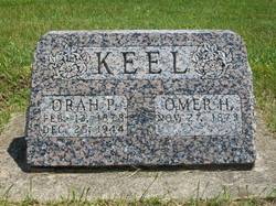
Orah P Miller Keel
| Birth | : | 13 Feb 1878 |
| Death | : | 25 Dec 1944 |
| Burial | : | Rose Hill Memorial Gardens, Missouri Valley, Harrison County, USA |
| Coordinate | : | 41.5656000, -95.8897000 |
| Plot | : | Section 10, Row 7 |
| Description | : | Published in The Rochester News-Sentinel Tuesday, December 26, 1944 Ora Keel Funeral services will be held Wednesday afternoon at 2 o'clock for Mrs. Ora KEEL, 66, wife of Omer KEEL, well-known farmer of the Woodrow neighborhood. Rev. Harry J. BAILEY of the First Baptist church will officiate and interment will be made in the IOOF cemetery. Mrs. Keel, ill since last August, passed away at her farm home early Christmas morning. She had been seriously ill for the past four weeks. Born Feb. 13, 1878, on a farm southwest of this city, she was the daughter of John and Clementine MILLER. On May 16, 1896,... Read More |
frequently asked questions (FAQ):
-
Where is Orah P Miller Keel's memorial?
Orah P Miller Keel's memorial is located at: Rose Hill Memorial Gardens, Missouri Valley, Harrison County, USA.
-
When did Orah P Miller Keel death?
Orah P Miller Keel death on 25 Dec 1944 in
-
Where are the coordinates of the Orah P Miller Keel's memorial?
Latitude: 41.5656000
Longitude: -95.8897000
Family Members:
Spouse
Children

Flowers:


Nearby Cemetories:
1. Rose Hill Memorial Gardens
Missouri Valley, Harrison County, USA
Coordinate: 41.5656000, -95.8897000
2. Mount Carmel Cemetery
Missouri Valley, Harrison County, USA
Coordinate: 41.5675011, -95.8897018
3. Champan Frazier Cemetery
Harrison County, USA
Coordinate: 41.5773500, -95.8933500
4. Hurleys Evergreen Cemetery
Harrison County, USA
Coordinate: 41.5700989, -95.8618698
5. Frazier Cemetery
Missouri Valley, Harrison County, USA
Coordinate: 41.5932999, -95.8375015
6. Oak Grove Cemetery
Missouri Valley, Harrison County, USA
Coordinate: 41.5167007, -95.8649979
7. Calhoun Cemetery
Calhoun, Harrison County, USA
Coordinate: 41.6391983, -95.8938980
8. Branson Cemetery
Loveland, Pottawattamie County, USA
Coordinate: 41.4846992, -95.8606033
9. Linnwood Cemetery
Harrison County, USA
Coordinate: 41.5589200, -95.7502100
10. Crook Cemetery
Honey Creek, Pottawattamie County, USA
Coordinate: 41.4581330, -95.8737000
11. Saint Bridgets Cemetery
Honey Creek, Pottawattamie County, USA
Coordinate: 41.4664001, -95.8289032
12. Logan Cemetery
Logan, Harrison County, USA
Coordinate: 41.6487579, -95.7843170
13. Harris Grove Cemetery
Beebeetown, Harrison County, USA
Coordinate: 41.5782928, -95.7262192
14. Magnolia Cemetery
Magnolia, Harrison County, USA
Coordinate: 41.6903000, -95.8799973
15. Allen Cemetery
Pottawattamie County, USA
Coordinate: 41.4427986, -95.8550034
16. Saint Bridgets Cemetery
Magnolia, Harrison County, USA
Coordinate: 41.6915660, -95.8812480
17. Grange Cemetery
Honey Creek, Pottawattamie County, USA
Coordinate: 41.4446678, -95.8034668
18. Hauger-Rumbaugh Cemetery
Modale, Harrison County, USA
Coordinate: 41.6388797, -96.0502906
19. Silver Hill Cemetery
Harrison County, USA
Coordinate: 41.6897011, -95.7919006
20. Reels Cemetery
Crescent, Pottawattamie County, USA
Coordinate: 41.4234100, -95.8321700
21. Yutesler Cemetery
Harrison County, USA
Coordinate: 41.6684000, -96.0373000
22. Fort Calhoun Cemetery
Fort Calhoun, Washington County, USA
Coordinate: 41.4581375, -96.0352020
23. Bethel Cemetery
Logan, Harrison County, USA
Coordinate: 41.6239014, -95.6999969
24. William C McIntosh Cemetery
Crescent, Pottawattamie County, USA
Coordinate: 41.4088745, -95.8477097