
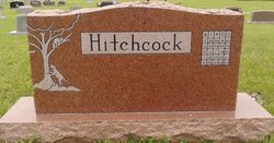
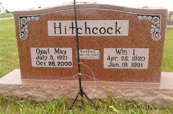
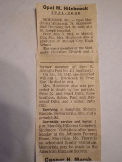
Opal May Dilts Hitchcock
| Birth | : | 3 Jul 1921 Skidmore, Nodaway County, Missouri, USA |
| Death | : | 26 Oct 2000 Saint Joseph, Buchanan County, Missouri, USA |
| Burial | : | St John the Baptist Churchyard, Purbrook, Havant Borough, England |
| Coordinate | : | 50.8678210, -1.0447060 |
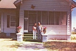
| Description | : | Generous woman with a good heart. She used to get down on the floor with me and play with Hot Wheels cars. She loved cats and Merle Haggard. Missed every day. Nicknamed "old woman" by me, she liked it, made her laugh |
frequently asked questions (FAQ):
-
Where is Opal May Dilts Hitchcock's memorial?
Opal May Dilts Hitchcock's memorial is located at: St John the Baptist Churchyard, Purbrook, Havant Borough, England.
-
When did Opal May Dilts Hitchcock death?
Opal May Dilts Hitchcock death on 26 Oct 2000 in Saint Joseph, Buchanan County, Missouri, USA
-
Where are the coordinates of the Opal May Dilts Hitchcock's memorial?
Latitude: 50.8678210
Longitude: -1.0447060
Family Members:
Parent
Siblings


Nearby Cemetories:
1. St John the Baptist Churchyard
Purbrook, Havant Borough, England
Coordinate: 50.8678210, -1.0447060
2. St Mary Magdalene Churchyard
Widley, City of Winchester, England
Coordinate: 50.8623650, -1.0642640
3. Christ Church Portsdown Churchyard
Widley, City of Winchester, England
Coordinate: 50.8547300, -1.0507540
4. St. George the Martyr Churchyard
Waterlooville, Havant Borough, England
Coordinate: 50.8804060, -1.0328690
5. Waterlooville Cemetery
Waterlooville, Havant Borough, England
Coordinate: 50.8802800, -1.0246400
6. St. Andrew's Churchyard
Farlington, Portsmouth Unitary Authority, England
Coordinate: 50.8477200, -1.0274510
7. St. Thomas Churchyard
Bedhampton, Havant Borough, England
Coordinate: 50.8529400, -1.0032960
8. St Peter and St Paul Churchyard
Wymering, Portsmouth Unitary Authority, England
Coordinate: 50.8457490, -1.0777170
9. Denmead Burial Ground
Denmead, City of Winchester, England
Coordinate: 50.9057570, -1.0662400
10. St. James' Churchyard
Southwick, City of Winchester, England
Coordinate: 50.8739800, -1.1113800
11. St. Faith's Churchyard
Havant, Havant Borough, England
Coordinate: 50.8513550, -0.9819910
12. New Lane Cemetery
Havant, Havant Borough, England
Coordinate: 50.8550670, -0.9753490
13. St John the Baptist Churchyard
Rowlands Castle, East Hampshire District, England
Coordinate: 50.8848500, -0.9695200
14. St. Mary's Churchyard
Portchester, Fareham Borough, England
Coordinate: 50.8366280, -1.1134270
15. Warblington Cemetery
Warblington, Havant Borough, England
Coordinate: 50.8431290, -0.9669690
16. St Thomas A Becket Churchyard
Warblington, Havant Borough, England
Coordinate: 50.8436920, -0.9660980
17. Roman Grove Cemetery
Portchester, Fareham Borough, England
Coordinate: 50.8384600, -1.1206200
18. Holy Trinity Churchyard
Blendworth, East Hampshire District, England
Coordinate: 50.9170620, -0.9895780
19. Catherington Cemetery
Catherington, East Hampshire District, England
Coordinate: 50.9254800, -1.0121200
20. Portchester Crematorium Gardens
Portchester, Fareham Borough, England
Coordinate: 50.8499680, -1.1382190
21. All Saints Churchyard
Catherington, East Hampshire District, England
Coordinate: 50.9259170, -1.0103890
22. St. Nicholas' Churchyard
Boarhunt, City of Winchester, England
Coordinate: 50.8709800, -1.1442000
23. Mile End Cemetery
Portsea, Portsmouth Unitary Authority, England
Coordinate: 50.8108900, -1.0876400
24. Kingston Cemetery
Portsmouth, Portsmouth Unitary Authority, England
Coordinate: 50.8031440, -1.0683260