
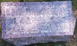
Orin Pierce McCreedy
| Birth | : | 17 Jun 1840 Schuylerville, Saratoga County, New York, USA |
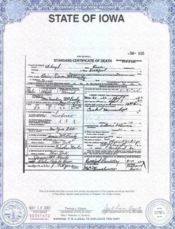
| Death | : | 9 Apr 1922 Rockford, Floyd County, Iowa, USA |
| Burial | : | Ss Mary and Clement Churchyard, Clavering, Uttlesford District, England |
| Coordinate | : | 51.9653720, 0.1393760 |
| Plot | : | Section 8 |
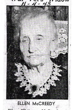
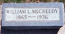
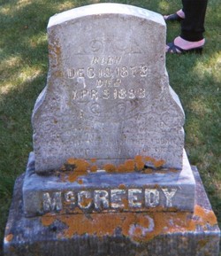
| Description | : | Orin Pierce McCreedy was the son of James and Emaline (Martin) McCreedy. On Oct 1, 1864 he married Ellen Whitman in Camp Grove, Marshall County, Illinois. During their marriage they lived in Freeborn County, Minnesota and in Butler and Floyd counties in Iowa. They spent the last 25 years of their married life living in Rockford, Floyd County, Iowa. After Orin's death on April 9, 1922, his wife Ellen moved to Cedar Rapids, Linn County, Iowa where she lived with their son George until her death in 1943 at age 98. Orin was the father of five sons: William L (Rosabel... Read More |
frequently asked questions (FAQ):
-
Where is Orin Pierce McCreedy's memorial?
Orin Pierce McCreedy's memorial is located at: Ss Mary and Clement Churchyard, Clavering, Uttlesford District, England.
-
When did Orin Pierce McCreedy death?
Orin Pierce McCreedy death on 9 Apr 1922 in Rockford, Floyd County, Iowa, USA
-
Where are the coordinates of the Orin Pierce McCreedy's memorial?
Latitude: 51.9653720
Longitude: 0.1393760
Family Members:
Parent
Spouse
Siblings
Children

Flowers:


Nearby Cemetories:
1. Ss Mary and Clement Churchyard
Clavering, Uttlesford District, England
Coordinate: 51.9653720, 0.1393760
2. All Saints Churchyard
Rickling, Uttlesford District, England
Coordinate: 51.9615100, 0.1798200
3. St Margaret Churchyard
Arkesden, Uttlesford District, England
Coordinate: 51.9897000, 0.1571200
4. Saint Mary Churchyard
Meesden, East Hertfordshire District, England
Coordinate: 51.9728000, 0.0934270
5. St. John The Evangelist Churchyard
Langley, Uttlesford District, England
Coordinate: 51.9969356, 0.0995640
6. Quendon Churchyard
Quendon, Uttlesford District, England
Coordinate: 51.9535800, 0.2038700
7. St Mary the Virgin Churchyard
Furneux Pelham, East Hertfordshire District, England
Coordinate: 51.9316710, 0.0808950
8. St Mary the Virgin Churchyard
Newport, Uttlesford District, England
Coordinate: 51.9845000, 0.2135600
9. The Hamlet Church Cemetery
Duddenhoe End, Uttlesford District, England
Coordinate: 52.0145269, 0.1285385
10. St Peter Churchyard
Ugley, Uttlesford District, England
Coordinate: 51.9364900, 0.2086500
11. St. Mary the Virgin Churchyard
Wendens Ambo, Uttlesford District, England
Coordinate: 52.0049490, 0.2029250
12. St George Churchyard
Anstey, East Hertfordshire District, England
Coordinate: 51.9766990, 0.0431300
13. St Mary the Virgin Churchyard
Widdington, Uttlesford District, England
Coordinate: 51.9629600, 0.2397600
14. St. Mary the Virgin Churchyard
Farnham, Uttlesford District, England
Coordinate: 51.9020340, 0.1517660
15. Holy Trinity Churchyard
Chrishall, Uttlesford District, England
Coordinate: 52.0276500, 0.1139577
16. Great Hormead St Nicholas Churchyard
Hormead, East Hertfordshire District, England
Coordinate: 51.9469500, 0.0353300
17. St Nicholas Churchyard
Little Chishill, South Cambridgeshire District, England
Coordinate: 52.0154690, 0.0654890
18. Little Hormead St Mary Churchyard
Hormead, East Hertfordshire District, England
Coordinate: 51.9428430, 0.0331630
19. St. Nicholas Churchyard
Elmdon, Uttlesford District, England
Coordinate: 52.0359900, 0.1294000
20. St Mary's Churchyard
Albury, East Hertfordshire District, England
Coordinate: 51.9026500, 0.0852920
21. St Mary the Virgin Churchyard
Henham, Uttlesford District, England
Coordinate: 51.9342500, 0.2456300
22. St Mary the Virgin and All Saints Churchyard
Debden, Uttlesford District, England
Coordinate: 51.9759030, 0.2568160
23. Hare Street Benson Grounds
Buntingford, East Hertfordshire District, England
Coordinate: 51.9492640, 0.0221120
24. St Swithin Churchyard
Great Chishill, South Cambridgeshire District, England
Coordinate: 52.0300090, 0.0715990