
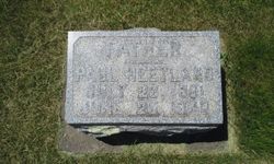
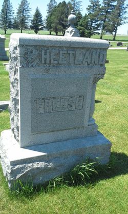
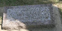
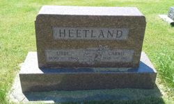
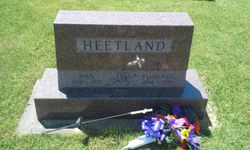
Paul Friederich Heetland
| Birth | : | 26 Jul 1861 Illinois, USA |
| Death | : | 26 Jun 1892 Hardin County, Iowa, USA |
| Burial | : | Holy Trinity Churchyard, Acaster Malbis, York Unitary Authority, England |
| Coordinate | : | 53.9052480, -1.0975170 |
| Plot | : | OC-108-E1 |
| Inscription | : | FATHER |
frequently asked questions (FAQ):
-
Where is Paul Friederich Heetland's memorial?
Paul Friederich Heetland's memorial is located at: Holy Trinity Churchyard, Acaster Malbis, York Unitary Authority, England.
-
When did Paul Friederich Heetland death?
Paul Friederich Heetland death on 26 Jun 1892 in Hardin County, Iowa, USA
-
Where are the coordinates of the Paul Friederich Heetland's memorial?
Latitude: 53.9052480
Longitude: -1.0975170
Family Members:
Parent
Spouse
Siblings
Children
Flowers:


Nearby Cemetories:
1. Holy Trinity Churchyard
Acaster Malbis, York Unitary Authority, England
Coordinate: 53.9052480, -1.0975170
2. St Matthew Churchyard
Naburn, York Unitary Authority, England
Coordinate: 53.9009520, -1.0899200
3. St. Andrew's Old Churchyard
Bishopthorpe, York Unitary Authority, England
Coordinate: 53.9221490, -1.0929640
4. St Andrew Churchyard
Bishopthorpe, York Unitary Authority, England
Coordinate: 53.9236690, -1.0955320
5. York Crematorium
York, York Unitary Authority, England
Coordinate: 53.9264970, -1.0936130
6. Dringhouses Cemetery
York, York Unitary Authority, England
Coordinate: 53.9297740, -1.1156780
7. St Giles Churchyard
Copmanthorpe, York Unitary Authority, England
Coordinate: 53.9149240, -1.1410420
8. Moor Lane Burial Ground
Copmanthorpe, York Unitary Authority, England
Coordinate: 53.9096890, -1.1449400
9. Fulford Cemetery
Fulford, York Unitary Authority, England
Coordinate: 53.9304450, -1.0683670
10. St. Edward the Confessor
Dringhouses, York Unitary Authority, England
Coordinate: 53.9399810, -1.1061270
11. St Oswald's Old Churchyard
Fulford, York Unitary Authority, England
Coordinate: 53.9391350, -1.0809020
12. St. Helen's Churchyard
Escrick, Selby District, England
Coordinate: 53.8805200, -1.0460990
13. St Nicholas Churchyard
Askham Bryan, York Unitary Authority, England
Coordinate: 53.9294600, -1.1581240
14. St Helen Churchyard
Stillingfleet, Selby District, England
Coordinate: 53.8618710, -1.0994760
15. Tyburn Cemetery
York, York Unitary Authority, England
Coordinate: 53.9486800, -1.1008400
16. St Clement Church
York, York Unitary Authority, England
Coordinate: 53.9511660, -1.0871720
17. St John Churchyard
Acaster Selby, Selby District, England
Coordinate: 53.8614750, -1.1283740
18. St Helen Churchyard
York, York Unitary Authority, England
Coordinate: 53.9509330, -1.0753630
19. York Cemetery
York, York Unitary Authority, England
Coordinate: 53.9503960, -1.0723530
20. Friends Burial Ground
York, York Unitary Authority, England
Coordinate: 53.9478920, -1.0618450
21. All Saints Churchyard
Appleton Roebuck, Selby District, England
Coordinate: 53.8734600, -1.1580870
22. St Paul Churchyard
Colton, Selby District, England
Coordinate: 53.8964660, -1.1773770
23. St Clement Priory Churchyard (Defunct)
York, York Unitary Authority, England
Coordinate: 53.9524710, -1.0827970
24. St Mary's Convent - The Bar Convent
York, York Unitary Authority, England
Coordinate: 53.9552520, -1.0911020