

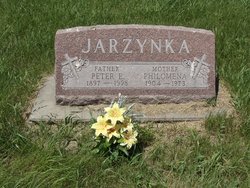
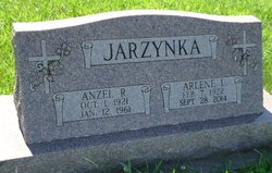
Peter Ervin Jarzynka
| Birth | : | 30 Sep 1897 Howard County, Nebraska, USA |
| Death | : | 19 Jan 1998 Saint Paul, Howard County, Nebraska, USA |
| Burial | : | Silver City Cemetery, Silver City, Mills County, USA |
| Coordinate | : | 41.1042442, -95.6380005 |
| Description | : | Son of John & Katherine (Koslicki) Jarzynka. Married to: 1. Teckla Cours on 1-21-1921 at Posen, NE. 2. Philomena Smedra on 4-24-1923 at Paplin, NE. |
frequently asked questions (FAQ):
-
Where is Peter Ervin Jarzynka's memorial?
Peter Ervin Jarzynka's memorial is located at: Silver City Cemetery, Silver City, Mills County, USA.
-
When did Peter Ervin Jarzynka death?
Peter Ervin Jarzynka death on 19 Jan 1998 in Saint Paul, Howard County, Nebraska, USA
-
Where are the coordinates of the Peter Ervin Jarzynka's memorial?
Latitude: 41.1042442
Longitude: -95.6380005
Family Members:
Parent
Spouse
Siblings

Children

Flowers:


Nearby Cemetories:
1. Silver City Cemetery
Silver City, Mills County, USA
Coordinate: 41.1042442, -95.6380005
2. East Liberty Cemetery
Malvern, Mills County, USA
Coordinate: 41.0592346, -95.6005020
3. Mineola Cemetery
Mineola, Mills County, USA
Coordinate: 41.1391130, -95.6941800
4. Mills County Farm Cemetery
Glenwood, Mills County, USA
Coordinate: 41.0417930, -95.6756530
5. Bomar Family Cemetery
Mills County, USA
Coordinate: 41.0369400, -95.6941700
6. West Liberty Cemetery
Glenwood, Mills County, USA
Coordinate: 41.0956001, -95.7536011
7. Saint Boniface Catholic Cemetery
Mills County, USA
Coordinate: 41.1419000, -95.7467100
8. Glenwood Catholic Cemetery
Glenwood, Mills County, USA
Coordinate: 41.0600000, -95.7453000
9. Cotten Cemetery
Mills County, USA
Coordinate: 41.0845000, -95.5167000
10. Glenwood Cemetery
Glenwood, Mills County, USA
Coordinate: 41.0599670, -95.7480240
11. Hillsdale Cemetery
Glenwood, Mills County, USA
Coordinate: 41.0097008, -95.6427994
12. Keg Creek Township Cemetery
Treynor, Pottawattamie County, USA
Coordinate: 41.1913986, -95.6893997
13. Glenwood Resource Center Cemetery
Glenwood, Mills County, USA
Coordinate: 41.0361720, -95.7338590
14. Zion Cemetery
Pottawattamie County, USA
Coordinate: 41.1778000, -95.7272000
15. Wearin Cemetery
Malvern, Mills County, USA
Coordinate: 41.0395000, -95.5313000
16. Saar's Field Cemetery
Mills County, USA
Coordinate: 41.1255500, -95.7725000
17. Wesley Chapel Cemetery
Henderson, Mills County, USA
Coordinate: 41.1019249, -95.4987793
18. Salem Lutheran Church Cemetery
Glenwood, Mills County, USA
Coordinate: 41.1556015, -95.7617035
19. Saint Pauls Evangelical Country Church Cemetery
Dumfries, Pottawattamie County, USA
Coordinate: 41.1748352, -95.7492371
20. Saylers Farm Cemetery
Henderson, Mills County, USA
Coordinate: 41.1083300, -95.4919440
21. Gowens-Turner Cemetery
Glenwood, Mills County, USA
Coordinate: 41.0715510, -95.7952420
22. Malvern Cemetery
Malvern, Mills County, USA
Coordinate: 40.9886017, -95.5785980
23. Saint Paul Lutheran Cemetery
Treynor, Pottawattamie County, USA
Coordinate: 41.2322000, -95.6380000
24. Zion Congregational Cemetery
Treynor, Pottawattamie County, USA
Coordinate: 41.2325090, -95.6079200