
| Birth | : | 1862 Sweden |
| Death | : | 28 May 1921 Bridgeport, Douglas County, Washington, USA |
| Burial | : | Howland Cemetery, Conway, Franklin County, USA |
| Coordinate | : | 42.5127983, -72.6967010 |
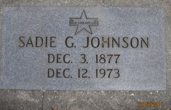
| Description | : | m: 3 Jan 1895 in Yoncalla, Oregon Washington Death Certificate Name:Peter John Johnson Death Date:28 May 1921 Death Place:Bridgeport, Douglas, Washington Gender:Male Age at Death:59 years Estimated Birth Year:1862 Marital Status:Married Spouse's Name:Sadie Gregory Johnson Father's Name:John Anderson Film Number:1992761 Digital GS Number:4221123 Image Number:917 Volume/Page/Certificate Number:rn 28 child: Freda Johnson McPherson b: 18 Feb 1910 d: 29 Dec 1996 |
frequently asked questions (FAQ):
-
Where is Peter John Johnson's memorial?
Peter John Johnson's memorial is located at: Howland Cemetery, Conway, Franklin County, USA.
-
When did Peter John Johnson death?
Peter John Johnson death on 28 May 1921 in Bridgeport, Douglas County, Washington, USA
-
Where are the coordinates of the Peter John Johnson's memorial?
Latitude: 42.5127983
Longitude: -72.6967010
Family Members:
Spouse
Children

Flowers:


Nearby Cemetories:
1. Howland Cemetery
Conway, Franklin County, USA
Coordinate: 42.5127983, -72.6967010
2. Pine Grove Cemetery
Conway, Franklin County, USA
Coordinate: 42.5222015, -72.6908035
3. South Centre Cemetery
Conway, Franklin County, USA
Coordinate: 42.5015940, -72.6973490
4. Maynard Cemetery
Conway, Franklin County, USA
Coordinate: 42.4836630, -72.7195800
5. Cricket Hill Cemetery
Conway, Franklin County, USA
Coordinate: 42.4783300, -72.7009500
6. Boyden Cemetery
Conway, Franklin County, USA
Coordinate: 42.4832993, -72.6667023
7. Mill River Cemetery
Deerfield, Franklin County, USA
Coordinate: 42.5011890, -72.6377770
8. Cosby Family Cemetery
Shelburne, Franklin County, USA
Coordinate: 42.5566400, -72.6702100
9. Hawks Cemetery
Deerfield, Franklin County, USA
Coordinate: 42.5555992, -72.6583023
10. South Part Cemetery
Conway, Franklin County, USA
Coordinate: 42.4625015, -72.6707993
11. Beldingville Cemetery
Ashfield, Franklin County, USA
Coordinate: 42.5365562, -72.7638016
12. South Ashfield Cemetery
Ashfield, Franklin County, USA
Coordinate: 42.5077209, -72.7730026
13. Savage Farm Cemetery
Deerfield, Franklin County, USA
Coordinate: 42.5336700, -72.6245300
14. North Shirkshire Cemetery
Conway, Franklin County, USA
Coordinate: 42.5689011, -72.7210999
15. Southwest Cemetery
Conway, Franklin County, USA
Coordinate: 42.4660280, -72.7458610
16. Baptist Corner Cemetery
Ashfield, Franklin County, USA
Coordinate: 42.5540771, -72.7639313
17. Baptist Cemetery
Deerfield, Franklin County, USA
Coordinate: 42.5555992, -72.6258011
18. Saint John's Church
Ashfield, Franklin County, USA
Coordinate: 42.5258600, -72.7894260
19. Plain Cemetery
Ashfield, Franklin County, USA
Coordinate: 42.5292015, -72.7889023
20. Shelburne Center Cemetery
Shelburne, Franklin County, USA
Coordinate: 42.5830000, -72.6969600
21. Old Deerfield Burying Ground
Deerfield, Franklin County, USA
Coordinate: 42.5449982, -72.6097031
22. South Cemetery
Shelburne, Franklin County, USA
Coordinate: 42.5819016, -72.6699982
23. Briar Hill Cemetery
Ashfield, Franklin County, USA
Coordinate: 42.4742600, -72.7798300
24. North Cemetery
Deerfield, Franklin County, USA
Coordinate: 42.5635100, -72.6249200