
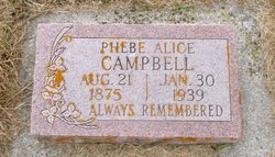
Phebe Alice Tolman Campbell
| Birth | : | 21 Aug 1875 Rush Valley, Tooele County, Utah, USA |
| Death | : | 30 Jan 1939 Hill Spring, Claresholm Census Division, Alberta, Canada |
| Burial | : | Forest Hill Church Cemetery, Forest Hill, South Oxfordshire District, England |
| Coordinate | : | 51.7641700, -1.1567100 |
| Description | : | |
frequently asked questions (FAQ):
-
Where is Phebe Alice Tolman Campbell's memorial?
Phebe Alice Tolman Campbell's memorial is located at: Forest Hill Church Cemetery, Forest Hill, South Oxfordshire District, England.
-
When did Phebe Alice Tolman Campbell death?
Phebe Alice Tolman Campbell death on 30 Jan 1939 in Hill Spring, Claresholm Census Division, Alberta, Canada
-
Where are the coordinates of the Phebe Alice Tolman Campbell's memorial?
Latitude: 51.7641700
Longitude: -1.1567100
Family Members:
Parent
Spouse
Siblings

Children
Flowers:


Nearby Cemetories:
1. Forest Hill Church Cemetery
Forest Hill, South Oxfordshire District, England
Coordinate: 51.7641700, -1.1567100
2. St. Nicholas' Church
Forest Hill, South Oxfordshire District, England
Coordinate: 51.7641400, -1.1567200
3. Saint John the Baptist
Stanton St John, South Oxfordshire District, England
Coordinate: 51.7800350, -1.1642830
4. Wheatley War Memorial
Wheatley, South Oxfordshire District, England
Coordinate: 51.7468630, -1.1388780
5. St Mary the Virgin Churchyard
Wheatley, South Oxfordshire District, England
Coordinate: 51.7476020, -1.1366080
6. Oxford Crematorium
Headington, City of Oxford, England
Coordinate: 51.7719240, -1.1904020
7. St Bartholomew Churchyard
Holton, South Oxfordshire District, England
Coordinate: 51.7529490, -1.1246510
8. Holy Trinity Churchyard
Headington, City of Oxford, England
Coordinate: 51.7577500, -1.1979980
9. St. Giles' Churchyard
Horspath, South Oxfordshire District, England
Coordinate: 51.7397190, -1.1738770
10. Cornerstone Church Cemetery
Headington, City of Oxford, England
Coordinate: 51.7587275, -1.1995588
11. The Priory
Headington, City of Oxford, England
Coordinate: 51.7638260, -1.2108100
12. St Andrew Churchyard
Headington, City of Oxford, England
Coordinate: 51.7647100, -1.2121400
13. St. Aldate's Churchyard
Oxford, City of Oxford, England
Coordinate: 51.7497900, -1.2118500
14. Assumption of the Blessed Virgin Mary Churchyard
Beckley, South Oxfordshire District, England
Coordinate: 51.7972530, -1.1858920
15. Headington Cemetery
Headington, City of Oxford, England
Coordinate: 51.7668050, -1.2179280
16. St Mary's Churchyard
Waterperry, South Oxfordshire District, England
Coordinate: 51.7521000, -1.0894000
17. Studley Priory
Horton-cum-Studley, Cherwell District, England
Coordinate: 51.8054560, -1.1346920
18. St Thomas of Canterbury Churchyard
Elsfield, South Oxfordshire District, England
Coordinate: 51.7858680, -1.2178310
19. All Saints Churchyard
Cuddesdon, South Oxfordshire District, England
Coordinate: 51.7230140, -1.1316130
20. St Barnabas Churchyard
Horton-cum-Studley, Cherwell District, England
Coordinate: 51.8077260, -1.1409690
21. Elsfield Road Cemetery
Old Marston, City of Oxford, England
Coordinate: 51.7752940, -1.2332640
22. St Mary and St John Church
Oxford, City of Oxford, England
Coordinate: 51.7452501, -1.2314021
23. Saint Mary's Churchyard
Garsington, South Oxfordshire District, England
Coordinate: 51.7140100, -1.1600700
24. Saint Leonard's Churchyard
Waterstock, South Oxfordshire District, England
Coordinate: 51.7451800, -1.0807500