

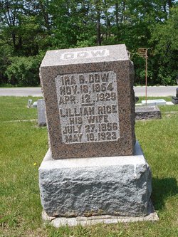
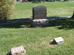
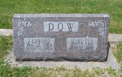
Phoebe Lillian Rice Dow
| Birth | : | 27 Jul 1855 Lee County, Iowa, USA |
| Death | : | 11 May 1923 Fort Madison, Lee County, Iowa, USA |
| Burial | : | Riverside Cemetery, Crow Wing County, USA |
| Coordinate | : | 46.2224998, -94.1893997 |
| Description | : | Mrs. Ira B. Dow of near Denmark, who was struck by an automobile in Fort Madison Monday afternoon, May 7, died Friday at 12:05 a.m. at the Sacred Heart hospital. Death was due to internal injuries and complications which set in after the accident. The accident, which resulted in Mrs. Dow's death, happened when she stepped from the curb into the path of the Ford car. The driver of the car, although traveling at a moderate rate of speed, was unable to stop in time to avoid striking the woman and the wheels passed over Mrs. Dow's head and... Read More |
frequently asked questions (FAQ):
-
Where is Phoebe Lillian Rice Dow's memorial?
Phoebe Lillian Rice Dow's memorial is located at: Riverside Cemetery, Crow Wing County, USA.
-
When did Phoebe Lillian Rice Dow death?
Phoebe Lillian Rice Dow death on 11 May 1923 in Fort Madison, Lee County, Iowa, USA
-
Where are the coordinates of the Phoebe Lillian Rice Dow's memorial?
Latitude: 46.2224998
Longitude: -94.1893997
Family Members:
Parent
Spouse
Siblings
Children
Flowers:


Nearby Cemetories:
1. Riverside Cemetery
Crow Wing County, USA
Coordinate: 46.2224998, -94.1893997
2. Saint Mathias Catholic Cemetery
Saint Mathias, Crow Wing County, USA
Coordinate: 46.2200000, -94.2517000
3. Pine Tree Cemetery
Crow Wing County, USA
Coordinate: 46.2122000, -94.1214000
4. Hillside Cemetery
Long Lake Township, Crow Wing County, USA
Coordinate: 46.2577000, -94.1037000
5. Pine Grove Cemetery
Crow Wing County, USA
Coordinate: 46.1713000, -94.2725000
6. Oak Land Cemetery
Crow Wing County, USA
Coordinate: 46.2722015, -94.3043976
7. Dixon Cemetery
Fort Ripley, Crow Wing County, USA
Coordinate: 46.2154930, -94.3246630
8. Oak Hill Cemetery
Crow Wing County, USA
Coordinate: 46.2158012, -94.3285980
9. Saint Francis Assisi Cemetery
Brainerd, Crow Wing County, USA
Coordinate: 46.2752980, -94.3352060
10. Saint John Holy Cross Cemetery
Brainerd, Crow Wing County, USA
Coordinate: 46.2790970, -94.3328890
11. Bethel Lutheran Cemetery
Crow Wing County, USA
Coordinate: 46.3147200, -94.0827800
12. Fort Ripley Cemetery
Fort Ripley, Crow Wing County, USA
Coordinate: 46.1761000, -94.3615700
13. Saint Marys Catholic Community Cemetery
Pierz, Morrison County, USA
Coordinate: 46.1093620, -94.0818390
14. Saint Pauls Episcopal Church Columbarium
Brainerd, Crow Wing County, USA
Coordinate: 46.3604205, -94.1988906
15. Vaale Cemetery
Brainerd, Crow Wing County, USA
Coordinate: 46.3224800, -94.0493950
16. Baxter Cemetery
Baxter, Crow Wing County, USA
Coordinate: 46.3455600, -94.2855600
17. Holy Cross Cemetery
Platte, Morrison County, USA
Coordinate: 46.1042000, -94.0813620
18. Evergreen Cemetery
Brainerd, Crow Wing County, USA
Coordinate: 46.3708000, -94.1859000
19. Holy Cross Church Cemetery
Pierz, Morrison County, USA
Coordinate: 46.1137400, -94.0408200
20. Freedhem Lutheran Cemetery
Freedhem, Morrison County, USA
Coordinate: 46.0612907, -94.2087021
21. Green Prairie Cemetery
Morrison County, USA
Coordinate: 46.1022400, -94.3527800
22. Freedhem Free Evangelical Cemetery
Freedhem, Morrison County, USA
Coordinate: 46.0559500, -94.2069600
23. Gull River Cemetery
Cass County, USA
Coordinate: 46.3356018, -94.3685989
24. Maple Grove Cemetery
Crow Wing County, USA
Coordinate: 46.3297005, -93.9993973