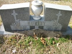
| Birth | : | 21 Apr 1923 |
| Death | : | 22 Jan 2002 |
| Burial | : | St. Mary de Castro Churchyard, Leicester, Leicester Unitary Authority, England |
| Coordinate | : | 52.6322610, -1.1404000 |
| Description | : | Daughter of Howard A. and Ruth Lord Todd. She graduated from Federalsburg High School Class of 1940. On Feb. 10, 1941 she entered Easton Emergency Hospital School of Nursing at Easton Memorial Hospital. She graduated on May 24, 1944 as a registered nurse. She practiced her profession doing general duty in the operating room, intensive care unit, assistant night supervisor and various other areas in the hospital. She also worked as an assistant head nurse at the Medical College of Virginia and at Grace Hospital in Richmond. She then became a private duty nurse until retiring in April 1987. She was... Read More |
frequently asked questions (FAQ):
-
Where is Phyllis Elaine Todd Hurley's memorial?
Phyllis Elaine Todd Hurley's memorial is located at: St. Mary de Castro Churchyard, Leicester, Leicester Unitary Authority, England.
-
When did Phyllis Elaine Todd Hurley death?
Phyllis Elaine Todd Hurley death on 22 Jan 2002 in
-
Where are the coordinates of the Phyllis Elaine Todd Hurley's memorial?
Latitude: 52.6322610
Longitude: -1.1404000
Family Members:
Parent
Spouse
Siblings
Flowers:
Nearby Cemetories:
1. St. Mary de Castro Churchyard
Leicester, Leicester Unitary Authority, England
Coordinate: 52.6322610, -1.1404000
2. Church of the Annunciation of St. Mary
Leicester, Leicester Unitary Authority, England
Coordinate: 52.6308229, -1.1417201
3. St. Nicholas Church
Leicester, Leicester Unitary Authority, England
Coordinate: 52.6351400, -1.1408940
4. Leicester Cathedral
Leicester, Leicester Unitary Authority, England
Coordinate: 52.6347430, -1.1370210
5. All Saints Church
Leicester, Leicester Unitary Authority, England
Coordinate: 52.6381940, -1.1403170
6. Great Meeting Unitarian Chapel
Leicester, Leicester Unitary Authority, England
Coordinate: 52.6379400, -1.1360390
7. St Margaret Churchyard
Leicester, Leicester Unitary Authority, England
Coordinate: 52.6403430, -1.1363440
8. St George's Church
Leicester, Leicester Unitary Authority, England
Coordinate: 52.6344300, -1.1267420
9. Welford Road Cemetery
Leicester, Leicester Unitary Authority, England
Coordinate: 52.6200104, -1.1295080
10. St Peter's Church (Defunct)
Leicester, Leicester Unitary Authority, England
Coordinate: 52.6300260, -1.1164980
11. Leicester Abbey
Leicester, Leicester Unitary Authority, England
Coordinate: 52.6489600, -1.1369470
12. St. john the Baptist
Leicester, Leicester Unitary Authority, England
Coordinate: 52.6181730, -1.1118790
13. Gilroes Cemetery and Crematorium
Leicester, Leicester Unitary Authority, England
Coordinate: 52.6514359, -1.1721700
14. St Peter's Churchyard
Braunstone, Blaby District, England
Coordinate: 52.6208940, -1.1812900
15. St. Peter's Churchyard
Belgrave, Leicester Unitary Authority, England
Coordinate: 52.6594208, -1.1255690
16. St Andrew Churchyard
Aylestone, Leicester Unitary Authority, England
Coordinate: 52.6038420, -1.1568900
17. Saint Mary Magdalene Churchyard
Knighton, Leicester Unitary Authority, England
Coordinate: 52.6054170, -1.1163730
18. Belgrave Cemetery
Belgrave, Leicester Unitary Authority, England
Coordinate: 52.6653570, -1.1311220
19. Saffron Hill Cemetery
Leicester, Leicester Unitary Authority, England
Coordinate: 52.5934120, -1.1310010
20. St. Mary's Churchyard
Humberstone, Leicester Unitary Authority, England
Coordinate: 52.6479200, -1.0760100
21. St. Denys' Churchyard
Evington, Leicester Unitary Authority, England
Coordinate: 52.6193210, -1.0743860
22. St Peter's Church
Glenfield, Blaby District, England
Coordinate: 52.6490490, -1.2063180
23. St James the Great Churchyard
Birstall, Charnwood Borough, England
Coordinate: 52.6741150, -1.1189210
24. Greengate Lane Cemetery
Birstall, Charnwood Borough, England
Coordinate: 52.6800110, -1.1346940


