
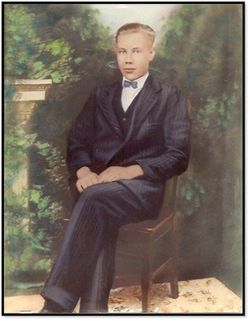
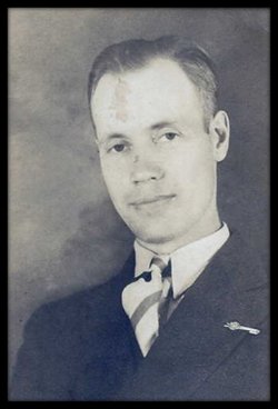
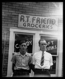

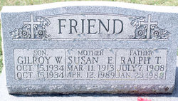
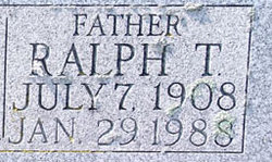
Ralph Taft Friend
| Birth | : | 7 Jul 1908 |
| Death | : | 29 Jan 1988 |
| Burial | : | Oak Grove Church of the Brethren Cemetery, McHenry, Garrett County, USA |
| Coordinate | : | 39.5694400, -79.3834300 |
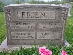
| Description | : | RALPH TAFT FRIEND Birth: July 7, 1908 Sang Run,Garrett County, Maryland Death: January 29, 1988 Garrett County Memorial Hospital Oakland, Maryland Son of Smith McClelland "Clellie" Friend (1862-1953) and Adelia Alice "Delia" (Friend) Friend (1867-1928). He was the youngest of their ten children. Married Susan Edna Whorton on December 19, 1927 at the home of "Aunt Jennie DeWitt" at Friends Delight in Sang Run. Of this union, four children: |
frequently asked questions (FAQ):
-
Where is Ralph Taft Friend's memorial?
Ralph Taft Friend's memorial is located at: Oak Grove Church of the Brethren Cemetery, McHenry, Garrett County, USA.
-
When did Ralph Taft Friend death?
Ralph Taft Friend death on 29 Jan 1988 in
-
Where are the coordinates of the Ralph Taft Friend's memorial?
Latitude: 39.5694400
Longitude: -79.3834300
Family Members:
Parent

Spouse

Siblings


Children

Flowers:


Nearby Cemetories:
1. Oak Grove Church of the Brethren Cemetery
McHenry, Garrett County, USA
Coordinate: 39.5694400, -79.3834300
2. Hoye Family Cemetery - Crab Tree Bottom
McHenry, Garrett County, USA
Coordinate: 39.5642220, -79.3855000
3. Saint Dominic Catholic Cemetery
Hoyes, Garrett County, USA
Coordinate: 39.5868300, -79.3698600
4. Hoyes Cemetery
Garrett County, USA
Coordinate: 39.5905991, -79.3683014
5. Upper Sang Run Cemetery
McHenry, Garrett County, USA
Coordinate: 39.5717810, -79.4242430
6. Flatwood Cemetery
Accident, Garrett County, USA
Coordinate: 39.5923500, -79.3515400
7. Skiles Cemetery
Accident, Garrett County, USA
Coordinate: 39.5971570, -79.3439160
8. Bumblebee Ridge Cemetery
McHenry, Garrett County, USA
Coordinate: 39.5774400, -79.3296800
9. Hoyes Run Cemetery
Garrett County, USA
Coordinate: 39.5313100, -79.4110900
10. Bray Cemetery
Oakland, Garrett County, USA
Coordinate: 39.5006900, -79.3858100
11. Glotfelty Farm Cemetery
McHenry, Garrett County, USA
Coordinate: 39.5708800, -79.2905500
12. Bear Creek Church of the Brethren Cemetery
Accident, Garrett County, USA
Coordinate: 39.6213000, -79.3099800
13. Saint Paul's Old Cemetery
Accident, Garrett County, USA
Coordinate: 39.6287100, -79.3182100
14. Friend Cemetery
Oakland, Garrett County, USA
Coordinate: 39.4913500, -79.3778000
15. Ruckle Family Cemetery
Bittinger, Garrett County, USA
Coordinate: 39.5802600, -79.2821900
16. Cherry Glade Cemetery
Accident, Garrett County, USA
Coordinate: 39.5827200, -79.2799500
17. Glade Mennonite Cemetery
Bittinger, Garrett County, USA
Coordinate: 39.5826300, -79.2796700
18. Zion Lutheran Cemetery
Accident, Garrett County, USA
Coordinate: 39.6300510, -79.3129020
19. Taylor-Sines Cemetery
Oakland, Garrett County, USA
Coordinate: 39.4894470, -79.4165480
20. Lake Ford Cemetery
Garrett County, USA
Coordinate: 39.5278015, -79.4792023
21. Cranesville Cemetery
Cranesville, Preston County, USA
Coordinate: 39.5543920, -79.4929870
22. Glendale Cemetery
Oakland, Garrett County, USA
Coordinate: 39.5085983, -79.2953033
23. Rodeheaver Cemetery
Oakland, Garrett County, USA
Coordinate: 39.4804680, -79.3521300
24. Sisler Cemetery
Mountain Dale, Preston County, USA
Coordinate: 39.6081009, -79.4938965