

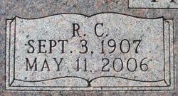
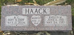
Raymond Charley Haack
| Birth | : | 3 Sep 1907 DeWitt, Clinton County, Iowa, USA |
| Death | : | 11 May 2006 Clinton, Clinton County, Iowa, USA |
| Burial | : | Hollybrook War Memorial, Southampton, Southampton Unitary Authority, England |
| Coordinate | : | 50.9337420, -1.4311350 |
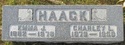
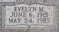
| Description | : | Mr. Raymond C. Haack, 98, DeWitt, Iowa, formerly of Grand Mound, Iowa, died Thursday morning, May 11, 2006 at Sarah Harding Home, Clinton, Iowa. Raymond Charley Haack was born September 3, 1907, the son of Charley and Emma (Mecklenburg) Haack. Ray married the former Evelyn Mae Petersen on Thanksgiving day, Thursday, November 27, 1941 at Immanuel Lutheran Church, Grand Mound. The couple farmed at rural Grand Mound, until 1978. Ray then worked for area farmers for several years. Evelyn preceded Ray in death May 24, 1985. He was a member of Grace Lutheran Church, DeWitt, and a former member of... Read More |
frequently asked questions (FAQ):
-
Where is Raymond Charley Haack's memorial?
Raymond Charley Haack's memorial is located at: Hollybrook War Memorial, Southampton, Southampton Unitary Authority, England.
-
When did Raymond Charley Haack death?
Raymond Charley Haack death on 11 May 2006 in Clinton, Clinton County, Iowa, USA
-
Where are the coordinates of the Raymond Charley Haack's memorial?
Latitude: 50.9337420
Longitude: -1.4311350
Family Members:
Parent

Spouse
Siblings
Flowers:


Nearby Cemetories:
1. Hollybrook War Memorial
Southampton, Southampton Unitary Authority, England
Coordinate: 50.9337420, -1.4311350
2. Hollybrook Cemetery
Southampton, Southampton Unitary Authority, England
Coordinate: 50.9340680, -1.4312970
3. St. James by the Park Cemetery
Southampton Unitary Authority, England
Coordinate: 50.9267988, -1.4283898
4. St James by the Park Churchyard
Shirley, Southampton Unitary Authority, England
Coordinate: 50.9266800, -1.4285800
5. Southampton Old Cemetery
Southampton, Southampton Unitary Authority, England
Coordinate: 50.9202900, -1.4130650
6. St. Nicholas Churchyard
Millbrook, Southampton Unitary Authority, England
Coordinate: 50.9139100, -1.4439800
7. Millbrook Cemetery
Millbrook, Southampton Unitary Authority, England
Coordinate: 50.9164900, -1.4526100
8. Holy Trinity Churchyard
Millbrook, Southampton Unitary Authority, England
Coordinate: 50.9158400, -1.4535100
9. Highfield Churchyard
Portswood, Southampton Unitary Authority, England
Coordinate: 50.9295400, -1.3949800
10. St John the Evangelist Churchyard
Rownhams, Test Valley Borough, England
Coordinate: 50.9520900, -1.4541200
11. Southampton Crematorium and Garden of Remembrance
Southampton, Southampton Unitary Authority, England
Coordinate: 50.9471770, -1.3899120
12. St. Deny's Churchyard
Chilworth, Test Valley Borough, England
Coordinate: 50.9669770, -1.4226050
13. St. Mary's Churchyard
Swaythling, Southampton Unitary Authority, England
Coordinate: 50.9367800, -1.3752300
14. All Saints Catacombs and Burial Ground (Defunct)
Southampton, Southampton Unitary Authority, England
Coordinate: 50.9013350, -1.4021500
15. St Michael the Archangel Churchyard
Southampton, Southampton Unitary Authority, England
Coordinate: 50.8996200, -1.4056900
16. St Mary Churchyard
Southampton, Southampton Unitary Authority, England
Coordinate: 50.9027100, -1.3960800
17. Holyrood Church
Southampton Unitary Authority, England
Coordinate: 50.8997498, -1.4034560
18. Holyrood Churchyard
Southampton, Southampton Unitary Authority, England
Coordinate: 50.8996600, -1.4035300
19. St. Mary the Virgin Churchyard
Eling, New Forest District, England
Coordinate: 50.9103000, -1.4795700
20. St Boniface Churchyard
Nursling, Test Valley Borough, England
Coordinate: 50.9464660, -1.4896760
21. St Lawrence with St John Churchyard
Southampton, Southampton Unitary Authority, England
Coordinate: 50.8977570, -1.4052470
22. Eling Cemetery
Eling, New Forest District, England
Coordinate: 50.9092640, -1.4817810
23. St Nicolas Churchyard
North Stoneham, Eastleigh Borough, England
Coordinate: 50.9535160, -1.3741760
24. St. Julien's Church
Southampton, Southampton Unitary Authority, England
Coordinate: 50.8965000, -1.4036000