
| Birth | : | 10 Nov 1842 Coles County, Illinois, USA |
| Death | : | 13 Feb 1913 Ainsworth, Brown County, Nebraska, USA |
| Burial | : | St John The Baptist Churchyard, Arkholme, City of Lancaster, England |
| Coordinate | : | 54.1406220, -2.6307800 |
| Plot | : | Block 9 Lot 10 Plot B |
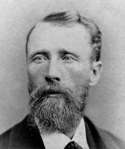
| Description | : | A son of Marcia Elisa Wilson and Reuben Barton he married Hester Ann Snow 10 May 1880 in Springville, Utah, UT. Hester was born 3 April 1863 in Springville, Utah, UT. and was the daughter of Bernard Snow and Annie Liversedge. Hester died 15 February 1930 in Ainsworth, Brown, NE, at 66 years of age. She was listed as the head of a family on the 1920 Census in Ainsworth, Brown, NE. with Ellis Snow Barton (son). When Reuben was about one and a half years old the family moved to Hancock County, Illinois, a Mormon community. His mother died... Read More |
frequently asked questions (FAQ):
-
Where is Reuben Almon Barton's memorial?
Reuben Almon Barton's memorial is located at: St John The Baptist Churchyard, Arkholme, City of Lancaster, England.
-
When did Reuben Almon Barton death?
Reuben Almon Barton death on 13 Feb 1913 in Ainsworth, Brown County, Nebraska, USA
-
Where are the coordinates of the Reuben Almon Barton's memorial?
Latitude: 54.1406220
Longitude: -2.6307800
Family Members:
Parent
Spouse

Siblings
Children
Flowers:


Nearby Cemetories:
1. St John The Baptist Churchyard
Arkholme, City of Lancaster, England
Coordinate: 54.1406220, -2.6307800
2. St Wilfrids Churchyard
Melling, City of Lancaster, England
Coordinate: 54.1346900, -2.6165100
3. St. John The Evangelist Churchyard
Gressingham, City of Lancaster, England
Coordinate: 54.1233910, -2.6557800
4. St James the Less Churchyard
Tatham, City of Lancaster, England
Coordinate: 54.1190100, -2.6043200
5. St. Wilfred Priory
Hornby, City of Lancaster, England
Coordinate: 54.1143640, -2.6405490
6. St. Margaret's Churchyard
Hornby, City of Lancaster, England
Coordinate: 54.1114000, -2.6362000
7. St John The Baptist Churchyard
Tunstall, City of Lancaster, England
Coordinate: 54.1596600, -2.5924200
8. Holy Trinity Churchyard
Wray, City of Lancaster, England
Coordinate: 54.1022960, -2.6081510
9. St. Michael the Archangel Churchyard
Whittington, City of Lancaster, England
Coordinate: 54.1807620, -2.6148790
10. St. Saviour's Church
Halton, City of Lancaster, England
Coordinate: 54.1025610, -2.6891750
11. St. Chad's Churchyard
Claughton, City of Lancaster, England
Coordinate: 54.0931310, -2.6643990
12. St. John the Baptist Churchyard
Bentham, Craven District, England
Coordinate: 54.1180880, -2.5454540
13. All Saints Churchyard
Burton-in-Lonsdale, Craven District, England
Coordinate: 54.1437630, -2.5357130
14. Friends Burial Group
Bentham, Craven District, England
Coordinate: 54.1265450, -2.5374290
15. St Cuthbert Churchyard
Over Kellet, City of Lancaster, England
Coordinate: 54.1195480, -2.7318200
16. Saint Peter's Churchyard
Leck, City of Lancaster, England
Coordinate: 54.1836860, -2.5485980
17. St John's Churchyard
Hutton Roof, South Lakeland District, England
Coordinate: 54.2029600, -2.6615600
18. St Mary the Virgin Churchyard
Kirkby Lonsdale, South Lakeland District, England
Coordinate: 54.2036550, -2.5976790
19. St James Churchyard
Burton-in-Kendal, South Lakeland District, England
Coordinate: 54.1859270, -2.7210310
20. St Margaret Churchyard
Bentham, Craven District, England
Coordinate: 54.1146000, -2.5087300
21. Carnforth Cemetery
Carnforth, City of Lancaster, England
Coordinate: 54.1245420, -2.7587820
22. St. Paul Churchyard
Caton, City of Lancaster, England
Coordinate: 54.0757840, -2.7009980
23. Holy Trinity Churchyard
Casterton, South Lakeland District, England
Coordinate: 54.2113570, -2.5768860
24. St. John the Evangelist Churchyard
Yealand Conyers, City of Lancaster, England
Coordinate: 54.1667470, -2.7565170