
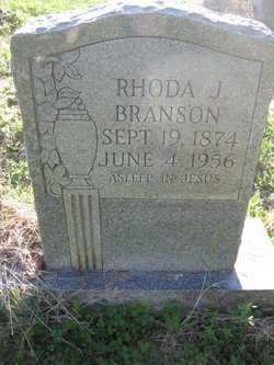
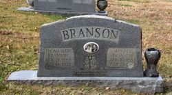
Rhoda Jane Branson
| Birth | : | 19 Sep 1874 Carroll County, Virginia, USA |
| Death | : | 4 Jun 1956 Mount Airy, Surry County, North Carolina, USA |
| Burial | : | Belknap Cemetery, Oakland, Pottawattamie County, USA |
| Coordinate | : | 41.2924995, -95.4424973 |
| Description | : | Daughter of Augusta and Carolyn Branson. |
frequently asked questions (FAQ):
-
Where is Rhoda Jane Branson's memorial?
Rhoda Jane Branson's memorial is located at: Belknap Cemetery, Oakland, Pottawattamie County, USA.
-
When did Rhoda Jane Branson death?
Rhoda Jane Branson death on 4 Jun 1956 in Mount Airy, Surry County, North Carolina, USA
-
Where are the coordinates of the Rhoda Jane Branson's memorial?
Latitude: 41.2924995
Longitude: -95.4424973
Family Members:
Parent
Siblings

Children


Nearby Cemetories:
1. Belknap Cemetery
Oakland, Pottawattamie County, USA
Coordinate: 41.2924995, -95.4424973
2. Big Grove Cemetery
Pottawattamie County, USA
Coordinate: 41.3088420, -95.4322120
3. Oaklawn Cemetery
Oakland, Pottawattamie County, USA
Coordinate: 41.3260994, -95.3818970
4. Carson Cemetery
Carson, Pottawattamie County, USA
Coordinate: 41.2392006, -95.4044037
5. Fairview Pioneer Cemetery
Treynor, Pottawattamie County, USA
Coordinate: 41.2812843, -95.5555267
6. Old Town Cemetery
Macedonia, Pottawattamie County, USA
Coordinate: 41.2030983, -95.4421997
7. Macedonia Cemetery
Macedonia, Pottawattamie County, USA
Coordinate: 41.1921997, -95.4167023
8. Wheeler Grove Cemetery
Macedonia, Pottawattamie County, USA
Coordinate: 41.2131691, -95.3393631
9. Bradway Farm Cemetery
Macedonia, Pottawattamie County, USA
Coordinate: 41.2083300, -95.3336500
10. Silver Valley Cemetery
Hancock, Pottawattamie County, USA
Coordinate: 41.4042015, -95.4969025
11. Mormon Cemetery
Macedonia, Pottawattamie County, USA
Coordinate: 41.1885986, -95.3557663
12. Oak Hill Cemetery
Hancock, Pottawattamie County, USA
Coordinate: 41.3908005, -95.3360977
13. Jones - Williams Cemetery
Pottawattamie County, USA
Coordinate: 41.3761000, -95.5846000
14. Zion Congregational Cemetery
Treynor, Pottawattamie County, USA
Coordinate: 41.2325090, -95.6079200
15. Buckner Cemetery
Wales, Montgomery County, USA
Coordinate: 41.1595600, -95.3440700
16. Hardin Township Cemetery
McClelland, Pottawattamie County, USA
Coordinate: 41.2949982, -95.6513977
17. Saint Paul Lutheran Cemetery
Treynor, Pottawattamie County, USA
Coordinate: 41.2322000, -95.6380000
18. Farm Creek Cemetery
Henderson, Mills County, USA
Coordinate: 41.1319008, -95.4186020
19. Pottawattamie County Home Cemetery
McClelland, Pottawattamie County, USA
Coordinate: 41.3269400, -95.6691738
20. Lincoln Township Cemetery
Hancock, Pottawattamie County, USA
Coordinate: 41.3824997, -95.2313995
21. Whipple Cemetery
Pottawattamie County, USA
Coordinate: 41.2882996, -95.1983032
22. Saylers Farm Cemetery
Henderson, Mills County, USA
Coordinate: 41.1083300, -95.4919440
23. Newtown Cemetery
Avoca, Pottawattamie County, USA
Coordinate: 41.4583200, -95.3169400
24. Center Ridge Cemetery
Montgomery County, USA
Coordinate: 41.1452141, -95.2787018