
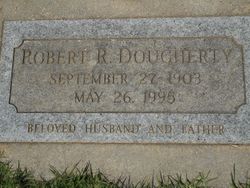

Robert Rowell Dougherty
| Birth | : | 27 Sep 1903 California, USA |
| Death | : | 26 May 1995 El Dorado, El Dorado County, California, USA |
| Burial | : | Newcastle Cemetery, Newcastle, Placer County, USA |
| Coordinate | : | 38.8708880, -121.1444060 |
| Description | : | Bio information provided by Andy, 47732259: Son of Florence Josephine (Summers) Dougherty (1860-1959), grandson of Charles L. Summers (ca 1834-1864), Find A Grave #23262112. |
frequently asked questions (FAQ):
-
Where is Robert Rowell Dougherty's memorial?
Robert Rowell Dougherty's memorial is located at: Newcastle Cemetery, Newcastle, Placer County, USA.
-
When did Robert Rowell Dougherty death?
Robert Rowell Dougherty death on 26 May 1995 in El Dorado, El Dorado County, California, USA
-
Where are the coordinates of the Robert Rowell Dougherty's memorial?
Latitude: 38.8708880
Longitude: -121.1444060
Family Members:
Parent

Spouse
Siblings
Flowers:


Nearby Cemetories:
1. Newcastle Cemetery
Newcastle, Placer County, USA
Coordinate: 38.8708880, -121.1444060
2. Ophir Cemetery
Placer County, USA
Coordinate: 38.8928870, -121.1273790
3. Stewarts Flat Cemetery
Penryn, Placer County, USA
Coordinate: 38.8447360, -121.1507950
4. Gold Hill Cemetery
Gold Hill, Placer County, USA
Coordinate: 38.9025000, -121.1802200
5. Maidu Indian Burial Grounds
Auburn, Placer County, USA
Coordinate: 38.8744350, -121.0777290
6. New Auburn Cemetery
Auburn, Placer County, USA
Coordinate: 38.9026900, -121.0870800
7. Clark Ashton Smith Gravesite
Auburn, Placer County, USA
Coordinate: 38.8952100, -121.0770500
8. Old Auburn Cemetery
Auburn, Placer County, USA
Coordinate: 38.9023720, -121.0812230
9. Bethlehem Lutheran Church Columbarium
Auburn, Placer County, USA
Coordinate: 38.8932350, -121.0749690
10. Mansur Family Cemetery
Loomis, Placer County, USA
Coordinate: 38.8139600, -121.1214000
11. Prosser Family Cemetery
Loomis, Placer County, USA
Coordinate: 38.8071900, -121.1285600
12. Placer County Hospital Cemetery
Auburn, Placer County, USA
Coordinate: 38.9045120, -121.0721320
13. Chinese Cemetery
Auburn, Placer County, USA
Coordinate: 38.9183502, -121.0802383
14. Rattlesnake Bar Graveyard
Auburn, Placer County, USA
Coordinate: 38.8163050, -121.0895100
15. First Congregational Church Memorial Garden
Auburn, Placer County, USA
Coordinate: 38.9118660, -121.0711770
16. Shepherd of the Sierra Memorial Garden
Loomis, Placer County, USA
Coordinate: 38.7890800, -121.1944200
17. Whitney Family Mausoleum
Rocklin, Placer County, USA
Coordinate: 38.8256500, -121.2477000
18. Wells Cemetery
Auburn, Placer County, USA
Coordinate: 38.9667000, -121.1054900
19. Bayley Family Cemetery
Pilot Hill, El Dorado County, USA
Coordinate: 38.8438800, -121.0148900
20. Lone Star Cemetery
Placer County, USA
Coordinate: 38.9757996, -121.1380997
21. Rocklin Cemetery
Rocklin, Placer County, USA
Coordinate: 38.7827670, -121.2337980
22. Pilot Hill Cemetery
Pilot Hill, El Dorado County, USA
Coordinate: 38.8301010, -121.0093307
23. Lincoln Cemetery
Lincoln, Placer County, USA
Coordinate: 38.8864310, -121.3020500
24. Clipper Gap Cemetery
Clipper Gap, Placer County, USA
Coordinate: 38.9784880, -121.0256590