Robert Stanley Prelip
| Birth | : | 2 Mar 1914 Kanawha, Hancock County, Iowa, USA |
| Death | : | Mar 1979 Hancock County, Iowa, USA |
| Burial | : | St John Churchyard, High Worsall, Hambleton District, England |
| Coordinate | : | 54.4786500, -1.4059590 |
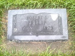
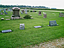
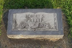
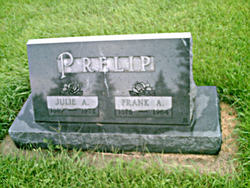
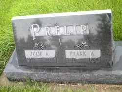
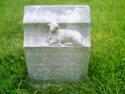
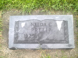
| Plot | : | In a lot with headstones for Robert S. Prelip, Richard James Prelip, Nelda C. Prelip, and Julie A. & Frank A. Prelip. |
| Description | : | Plot has headstones for Richard James Prelip, Nelda C. Prelip, and Julie A. & Frank A. Prelip. See also: Kemp, Clara Louise Prelip; Kemp, Clara Louise Prelip; Kemp, Martha Augusta Prelip; Prelip, Arthur George; Prelip, Carl E.; Prelip, Eugene; Prelip, Frank Arthur; Prelip, Fredrick Fred; Prelip, Julia Katrine Andreasen; Prelip, Louisa Elizabeth Mallwitz Hein; Prelip, Mary Sobek; Prelip, Mary I.; Prelip, Nelda C.; Prelip, Oda Elnora Andreasen; Prelip, Richard James; Prelip, Robert S.; Prilipp, Anna Marie; Prilipp, Cora Laura Hauck; Prilipp, Margery... Read More |
frequently asked questions (FAQ):
-
Where is Robert Stanley Prelip's memorial?
Robert Stanley Prelip's memorial is located at: St John Churchyard, High Worsall, Hambleton District, England.
-
When did Robert Stanley Prelip death?
Robert Stanley Prelip death on Mar 1979 in Hancock County, Iowa, USA
-
Where are the coordinates of the Robert Stanley Prelip's memorial?
Latitude: 54.4786500
Longitude: -1.4059590
Family Members:
Parent
Siblings
Flowers:
Nearby Cemetories:
1. St John Churchyard
High Worsall, Hambleton District, England
Coordinate: 54.4786500, -1.4059590
2. All Saints Churchyard
Low Worsall, Hambleton District, England
Coordinate: 54.4824880, -1.3898180
3. Saint George's Churchyard Low Middleton
Middleton St George, Darlington Unitary Authority, England
Coordinate: 54.4994000, -1.4366000
4. All Saints Churchyard
Girsby, Hambleton District, England
Coordinate: 54.4691000, -1.4554000
5. All Saints Churchyard
Sockburn, Darlington Unitary Authority, England
Coordinate: 54.4582000, -1.4619000
6. Yarm Cemetery
Yarm, Stockton-on-Tees Unitary Authority, England
Coordinate: 54.5037700, -1.3559300
7. Saint John the Baptist Churchyard
Low Dinsdale, Darlington Unitary Authority, England
Coordinate: 54.4950000, -1.4660000
8. St. Martin's Churchyard
Kirklevington, Stockton-on-Tees Unitary Authority, England
Coordinate: 54.4822940, -1.3351050
9. Saint Mary Magdalene Churchyard
Yarm, Stockton-on-Tees Unitary Authority, England
Coordinate: 54.5101150, -1.3575280
10. Saint Laurence's Churchyard
Middleton St George, Darlington Unitary Authority, England
Coordinate: 54.5054700, -1.4625400
11. St Mary Churchyard
Appleton Wiske, Hambleton District, England
Coordinate: 54.4360250, -1.4003270
12. St. John the Baptist Churchyard
Egglescliffe, Stockton-on-Tees Unitary Authority, England
Coordinate: 54.5121000, -1.3518000
13. Egglescliffe Cemetery
Egglescliffe, Stockton-on-Tees Unitary Authority, England
Coordinate: 54.5127200, -1.3520100
14. All Saints Churchyard
Crathorne, Hambleton District, England
Coordinate: 54.4615000, -1.3176000
15. St Eloy Churchyard
Great Smeaton, Hambleton District, England
Coordinate: 54.4343000, -1.4647000
16. Neasham Priory
Sockburn, Darlington Unitary Authority, England
Coordinate: 54.4851000, -1.5035000
17. St Mary the Virgin Churchyard
Eryholme, Richmondshire District, England
Coordinate: 54.4754000, -1.5067000
18. St Oswald Churchyard
West Rounton, Hambleton District, England
Coordinate: 54.4243670, -1.3638680
19. St. Mary's Churchyard
Long Newton, Stockton-on-Tees Unitary Authority, England
Coordinate: 54.5417700, -1.4098500
20. St. Lawrence Churchyard
East Rounton, Hambleton District, England
Coordinate: 54.4241000, -1.3510700
21. St Leonard Churchyard
Welbury, Hambleton District, England
Coordinate: 54.4138000, -1.3855600
22. All Saints Churchyard
Deighton, Hambleton District, England
Coordinate: 54.4099130, -1.4141500
23. All Saints Churchyard
Hurworth, Darlington Unitary Authority, England
Coordinate: 54.4869900, -1.5285200
24. St. John's Churchyard
Elton, Stockton-on-Tees Unitary Authority, England
Coordinate: 54.5500830, -1.3803290

