
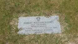
Robert William “Bob” Woods
| Birth | : | 3 Aug 1928 Vegreville, Lloydminster Census Division, Alberta, Canada |
| Death | : | 12 Dec 2011 Chester, Liberty County, Montana, USA |
| Burial | : | Highland Cemetery, Havre, Hill County, USA |
| Coordinate | : | 48.5463982, -109.6900024 |
| Plot | : | Space 635 Block 34 |
| Inscription | : | SGT US ARMY WORLD WAR II AFFECTIONATELY KNOWN AS BOB |
| Description | : | In 1940 he, his parents, his sister, and their paternal grandmother lived in a house they were renting for ten dollars a month on Second Avenue West in Inverness, MT. His father worked as a farm laborer, his mother as a secretary and clerk for the school board, and Aileen as a clerk for the post office department. Their incomes for weeks worked in 1939 were $100/26, $100/10, and $85/16, respectively. Great Falls (MT) Gazette, December 15, 2011: Robert William 'Bob' Woods was born Aug. 3, 1928, in Vergreville, Alberta, one of two children of Robert and Esther... Read More |
frequently asked questions (FAQ):
-
Where is Robert William “Bob” Woods's memorial?
Robert William “Bob” Woods's memorial is located at: Highland Cemetery, Havre, Hill County, USA.
-
When did Robert William “Bob” Woods death?
Robert William “Bob” Woods death on 12 Dec 2011 in Chester, Liberty County, Montana, USA
-
Where are the coordinates of the Robert William “Bob” Woods's memorial?
Latitude: 48.5463982
Longitude: -109.6900024
Family Members:
Parent
Spouse

Siblings

Flowers:


Nearby Cemetories:
1. Highland Cemetery
Havre, Hill County, USA
Coordinate: 48.5463982, -109.6900024
2. Calvary Cemetery
Havre, Hill County, USA
Coordinate: 48.5457000, -109.6883000
3. Mount Hope Cemetery
Havre, Hill County, USA
Coordinate: 48.5540000, -109.7050000
4. Sunset Garden Park
Havre, Hill County, USA
Coordinate: 48.5531006, -109.8019028
5. North Havre Lutheran Church Graveyard (Defunct)
Havre, Hill County, USA
Coordinate: 48.6538903, -109.6815870
6. Grainbelt Cemetery
Hill County, USA
Coordinate: 48.6828003, -109.8657990
7. Andrew S. Lohman Grave Site
Lohman, Blaine County, USA
Coordinate: 48.5903520, -109.4073350
8. East End Colony Cemetery
East End Colony, Hill County, USA
Coordinate: 48.7485000, -109.5474000
9. Hilldale Hutterite Colony Cemetery
Hilldale Colony, Hill County, USA
Coordinate: 48.7997000, -109.7872000
10. Saint Johns Catholic Cemetery
Havre, Hill County, USA
Coordinate: 48.7625008, -109.9638977
11. Saint Gabriel Cemetery
Chinook, Blaine County, USA
Coordinate: 48.6065200, -109.2531200
12. Kuper Memorial Cemetery
Chinook, Blaine County, USA
Coordinate: 48.6083100, -109.2531200
13. Rocky Boy Cemetery
Rocky Boy, Hill County, USA
Coordinate: 48.2572410, -109.7923690
14. Box Elder Cemetery
Box Elder, Hill County, USA
Coordinate: 48.3274000, -110.0095000
15. Rocky Boy Gravel Cemetery
Rocky Boy, Hill County, USA
Coordinate: 48.2427720, -109.7596500
16. Cottonwood Lutheran Church Cemetery
Havre, Hill County, USA
Coordinate: 48.4545000, -110.1748000
17. Bear Paw Battlefield
Chinook, Blaine County, USA
Coordinate: 48.3780070, -109.2121290
18. Hungry Hollow Cemetery
Blaine County, USA
Coordinate: 48.2103004, -109.4677963
19. Milk River Valley Church Graveyard
Hill County, USA
Coordinate: 48.6787180, -110.2261080
20. Hollandville Cemetery
Chinook, Blaine County, USA
Coordinate: 48.6960310, -109.1557200
21. Gildford Hill County Cemetery
Gildford, Hill County, USA
Coordinate: 48.5778008, -110.2957993
22. Prairie Chapel United Brethren Cemetery
Chinook, Blaine County, USA
Coordinate: 48.8860000, -109.3414000
23. Mennonite Brethren Cemetery
Chinook, Blaine County, USA
Coordinate: 48.8012560, -109.1980620
24. Bethel Bruderthaler Mennonite Church Cemetery
Chinook, Blaine County, USA
Coordinate: 48.7552000, -109.1345000