
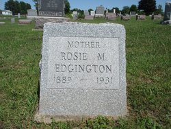

Rosie May Berry Edgington
| Birth | : | 18 Feb 1889 Union County, Iowa, USA |
| Death | : | 25 May 1931 Lamoni, Decatur County, Iowa, USA |
| Burial | : | Hambey Cemetery, Monterey County, USA |
| Coordinate | : | 36.8372002, -121.6793976 |
| Plot | : | Section 1s, Lot 119, Space 4 |
| Description | : | Married to Clyde T Edgington |
frequently asked questions (FAQ):
-
Where is Rosie May Berry Edgington's memorial?
Rosie May Berry Edgington's memorial is located at: Hambey Cemetery, Monterey County, USA.
-
When did Rosie May Berry Edgington death?
Rosie May Berry Edgington death on 25 May 1931 in Lamoni, Decatur County, Iowa, USA
-
Where are the coordinates of the Rosie May Berry Edgington's memorial?
Latitude: 36.8372002
Longitude: -121.6793976
Family Members:
Parent
Spouse

Children
Flowers:


Nearby Cemetories:
1. Hambey Cemetery
Monterey County, USA
Coordinate: 36.8372002, -121.6793976
2. Monterey Bay Loved Pet Cemetery
Monterey County, USA
Coordinate: 36.8326160, -121.6812820
3. Stephen Norriss Gravesite
Monterey County, USA
Coordinate: 36.8214110, -121.7601080
4. Queen of Heaven Cemetery
Prunedale, Monterey County, USA
Coordinate: 36.7602425, -121.6611252
5. Castroville Public Cemetery
Moss Landing, Monterey County, USA
Coordinate: 36.7930145, -121.7851410
6. All Saints Episcopal Church Memorial Garden
Watsonville, Santa Cruz County, USA
Coordinate: 36.9102310, -121.7568950
7. San Juan Bautista Cemetery
San Juan Bautista, San Benito County, USA
Coordinate: 36.8457985, -121.5438995
8. Santa Rita Chapel and Cemetery
Salinas, Monterey County, USA
Coordinate: 36.7281303, -121.6565475
9. Pioneer Cemetery
Watsonville, Santa Cruz County, USA
Coordinate: 36.9258560, -121.7642790
10. Watsonville Catholic Cemetery
Watsonville, Santa Cruz County, USA
Coordinate: 36.9278564, -121.7658463
11. Valley Catholic Cemetery
Watsonville, Santa Cruz County, USA
Coordinate: 36.9415932, -121.7405777
12. Valley Public Cemetery
Watsonville, Santa Cruz County, USA
Coordinate: 36.9418983, -121.7400513
13. Mission San Juan Bautista Cemetery
San Juan Bautista, San Benito County, USA
Coordinate: 36.8460007, -121.5339966
14. Pajaro Valley Memorial Park
Watsonville, Santa Cruz County, USA
Coordinate: 36.9629669, -121.7219391
15. Saint Georges Episcopal Church Columbarium
Salinas, Monterey County, USA
Coordinate: 36.7062580, -121.6440980
16. Monterey County Potters Field Cemetery
Salinas, Monterey County, USA
Coordinate: 36.6960900, -121.6381950
17. Chinese Cemetery
Salinas, Monterey County, USA
Coordinate: 36.6952057, -121.6390381
18. Calvary Catholic Cemetery
Salinas, Monterey County, USA
Coordinate: 36.6880341, -121.6818085
19. Saint Pauls Episcopal Church Columbarium
Salinas, Monterey County, USA
Coordinate: 36.6588430, -121.6558850
20. Garden of Memories
Salinas, Monterey County, USA
Coordinate: 36.6565247, -121.6384125
21. Yamato Cemetery
Salinas, Monterey County, USA
Coordinate: 36.6552811, -121.6307297
22. Gavilan Hills Memorial Park
Gilroy, Santa Clara County, USA
Coordinate: 37.0124000, -121.5909200
23. Saint Mary Cemetery
Gilroy, Santa Clara County, USA
Coordinate: 37.0134300, -121.5882000
24. Whitcher Cemetery
East Garrison, Monterey County, USA
Coordinate: 36.6501730, -121.7305270