
| Birth | : | 10 Oct 1921 |
| Death | : | 9 Sep 1944 Germany |
| Burial | : | Newton Road Cemetery, Rushden, East Northamptonshire Borough, England |
| Coordinate | : | 52.2882140, -0.5859750 |
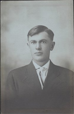
| Description | : | Tail Gunner - T/Sgt. Roy E. Herndon KIA Squadron 847th BS 489th Bomb Group May have been transferred from 389th Bomb Group 564th BS on or about 12 May 1944. Hometown: Missouri Service # 17122516 Awards: Distinguished Flying Cross, Air Medal with 3 Oak Leaf Clusters, Purple Heart Pilot Capt. Thomas M. Plese. KIA Missing Air Crew Report Details USAAF MACR#: 8905 Target:Marshaling Yards; Mainz, Germany. Mission Date:9-Sep-44 Serial Number: #42-50897 Aircraft Model B-24 Aircraft Letter: Aircraft Name: Location:lost over Bauscheim, Germany Cause: Notes: This was a Lead Pathfinder B24 with ( Mickey) Radar Equipped 12 man crew. Mission Pilot - Major William Blum Radar ( Mickey ) Operator - Lt. Clifford Lafary Tail Gunner... Read More |
frequently asked questions (FAQ):
-
Where is Roy Edmund Herndon's memorial?
Roy Edmund Herndon's memorial is located at: Newton Road Cemetery, Rushden, East Northamptonshire Borough, England.
-
When did Roy Edmund Herndon death?
Roy Edmund Herndon death on 9 Sep 1944 in Germany
-
Where are the coordinates of the Roy Edmund Herndon's memorial?
Latitude: 52.2882140
Longitude: -0.5859750
Family Members:
Parent
Siblings
Flowers:


Nearby Cemetories:
1. Newton Road Cemetery
Rushden, East Northamptonshire Borough, England
Coordinate: 52.2882140, -0.5859750
2. St Mary Churchyard
Rushden, East Northamptonshire Borough, England
Coordinate: 52.2885570, -0.5973860
3. St. Mary the Virgin Churchyard
Higham Ferrers, East Northamptonshire Borough, England
Coordinate: 52.3065500, -0.5915240
4. Higham Ferrers Cemetery
Higham Ferrers, East Northamptonshire Borough, England
Coordinate: 52.3084850, -0.5945270
5. St Lawrence Churchyard
Wymington, Bedford Borough, England
Coordinate: 52.2694310, -0.6017230
6. St. Peter Churchyard
Newton Bromswold, East Northamptonshire Borough, England
Coordinate: 52.2815200, -0.5376600
7. St. John the Baptist Churchyard
Chelveston, East Northamptonshire Borough, England
Coordinate: 52.3112800, -0.5501200
8. Irchester Saint Katherine Churchyard
Irchester, Wellingborough Borough, England
Coordinate: 52.2843900, -0.6446900
9. Irchester Cemetery
Irchester, Wellingborough Borough, England
Coordinate: 52.2848000, -0.6456000
10. New Irthlingborough Cemetery
Irthlingborough, East Northamptonshire Borough, England
Coordinate: 52.3178531, -0.6294229
11. St Peter's Churchyard
Irthlingborough, East Northamptonshire Borough, England
Coordinate: 52.3251642, -0.6101925
12. St Mary the Virgin Churchyard
Podington, Bedford Borough, England
Coordinate: 52.2539100, -0.6220900
13. St. Mary the Virgin Churchyard
Yelden, Bedford Borough, England
Coordinate: 52.2930600, -0.5182700
14. St. Michael's Church
Farndish, Bedford Borough, England
Coordinate: 52.2638108, -0.6416839
15. St. Margaret of Antioch Churchyard
Knotting, Bedford Borough, England
Coordinate: 52.2599172, -0.5323686
16. Stanwick Cemetery
Stanwick, East Northamptonshire Borough, England
Coordinate: 52.3298800, -0.5531500
17. St. Laurence Churchyard Stanwick
Stanwick, East Northamptonshire Borough, England
Coordinate: 52.3324970, -0.5628585
18. All Saints Churchyard
Souldrop, Bedford Borough, England
Coordinate: 52.2433000, -0.5584000
19. St. Mary Magdalene Churchyard
Melchbourne, Bedford Borough, England
Coordinate: 52.2770600, -0.4935690
20. Wollaston
Wollaston, Wellingborough Borough, England
Coordinate: 52.2581088, -0.6726313
21. London Road Cemetery
Wellingborough, Wellingborough Borough, England
Coordinate: 52.2986000, -0.6878000
22. All Saints Churchyard
Wellingborough, Wellingborough Borough, England
Coordinate: 52.3010890, -0.6879730
23. St Mary the Virgin Churchyard
Shelton, Bedford Borough, England
Coordinate: 52.3076000, -0.4852000
24. Raunds Cemetery
Raunds, East Northamptonshire Borough, England
Coordinate: 52.3494100, -0.5467400