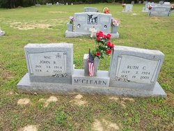
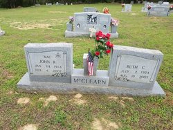
Ruth Corinne Coburn McClearn
| Birth | : | 2 Jul 1924 Gibson County, Tennessee, USA |
| Death | : | 19 Aug 2003 Jackson, Madison County, Tennessee, USA |
| Burial | : | Bellevernon Cemetery, Friendship, Crockett County, USA |
| Coordinate | : | 35.9135830, -89.2495910 |
| Description | : | Ruth Corinne McClearn, 79, of Friendship, Tenn., died Tuesday, August 19, 2003, at West Tennessee Transitional Care in Jackson, Tenn. Born July 2, 1924, in Gibson County, Tenn., she was the daughter of the late Herbert Foster Coburn and Elsie Louise Coburn. She was also preceded in death by one sister, Ramona Foster. She was a homemaker and a member of the Friendship Baptist Church, where she taught Sunday School for many years. Other than her family, she influenced and was instrumental in the rearing of many young children. Mrs. McClearn leaves her husband, J.R. "Mac" McClearn of Friendship; One daughter,... Read More |
frequently asked questions (FAQ):
-
Where is Ruth Corinne Coburn McClearn's memorial?
Ruth Corinne Coburn McClearn's memorial is located at: Bellevernon Cemetery, Friendship, Crockett County, USA.
-
When did Ruth Corinne Coburn McClearn death?
Ruth Corinne Coburn McClearn death on 19 Aug 2003 in Jackson, Madison County, Tennessee, USA
-
Where are the coordinates of the Ruth Corinne Coburn McClearn's memorial?
Latitude: 35.9135830
Longitude: -89.2495910
Family Members:
Spouse
Flowers:
Nearby Cemetories:
1. Bellevernon Cemetery
Friendship, Crockett County, USA
Coordinate: 35.9135830, -89.2495910
2. Friendship Cemetery
Friendship, Crockett County, USA
Coordinate: 35.9146430, -89.2381450
3. Mount Moriah Cemetery
Friendship, Crockett County, USA
Coordinate: 35.8955420, -89.2576300
4. Bowen Chapel Cemetery
Friendship, Dyer County, USA
Coordinate: 35.9311810, -89.2353720
5. Mose M. Thompson Cemetery
Friendship, Dyer County, USA
Coordinate: 35.9243680, -89.2765870
6. Hardin Cemetery
Friendship, Dyer County, USA
Coordinate: 35.9243270, -89.2766430
7. Nash Cemetery
Dyersburg, Dyer County, USA
Coordinate: 35.9252500, -89.2822230
8. Robertson-Warren Cemetery
Friendship, Crockett County, USA
Coordinate: 35.8830700, -89.2427200
9. Mount Pisgah Cemetery
Friendship, Dyer County, USA
Coordinate: 35.9162470, -89.2901740
10. Zion Hill Church Cemetery
Friendship, Dyer County, USA
Coordinate: 35.9095110, -89.2900760
11. Edwards Cemetery
Friendship, Crockett County, USA
Coordinate: 35.9314120, -89.2146810
12. Deaton Cemetery
Friendship, Crockett County, USA
Coordinate: 35.9350080, -89.2122640
13. Mount Zion Cemetery
Friendship, Crockett County, USA
Coordinate: 35.9131950, -89.2032590
14. Staggs Cemetery
Friendship, Dyer County, USA
Coordinate: 35.9397930, -89.2896620
15. Old Dyer Church Cemetery
Friendship, Crockett County, USA
Coordinate: 35.8844600, -89.2101900
16. Allen Chapel Cemetery
Tigrett, Dyer County, USA
Coordinate: 35.9511400, -89.2207500
17. Hendrix Cemetery
Tigrett, Dyer County, USA
Coordinate: 35.9511500, -89.2206950
18. Cock and Irvin Cemetery
Hawkinsville, Dyer County, USA
Coordinate: 35.9104430, -89.3046210
19. Mays Chapel Cemetery
Friendship, Crockett County, USA
Coordinate: 35.9363540, -89.2006050
20. Jones Cemetery
Tigrett, Dyer County, USA
Coordinate: 35.9552230, -89.2747450
21. Saint Peter Cemetery
Tigrett, Dyer County, USA
Coordinate: 35.9616440, -89.2520140
22. Williams Chapel Baptist Church Cemetery
Friendship, Crockett County, USA
Coordinate: 35.9258940, -89.1916320
23. Browder Family Cemetery
Broadview, Crockett County, USA
Coordinate: 35.8646890, -89.2623010
24. McGary Family Cemetery
Tigrett, Dyer County, USA
Coordinate: 35.9649530, -89.2501520


