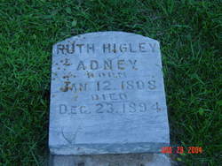
Ruth Higley Adney
| Birth | : | 12 Jan 1808 Meigs County, Ohio, USA |
| Death | : | 23 Dec 1894 Clayton County, Iowa, USA |
| Burial | : | Christ Church Churchyard, Over Wyresdale, City of Lancaster, England |
| Coordinate | : | 53.9839250, -2.6861150 |
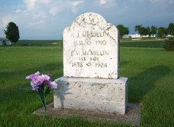
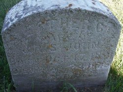
| Description | : | Not sure which or if either last name is her Nee. Per email of 30 March 2008. Her Maiden name was Higley, the daughter of Elam Higley, she was born in Meigs County, Ohio. Thanks ∼A FindAGrave Member contributes: Ruth Higley was the daughter of Elam Higley and Jane McMillin per our family historian, John Robert Adney. The Glenn name on her marriage record to William Adney is a mystery. Perhaps she was adopted by the Glenns after her parents' divorce. The Adney family did not mention her second husband, Henry McMillin, that she married on Dec. 14th, 1874. ~~~~... Read More |
frequently asked questions (FAQ):
-
Where is Ruth Higley Adney's memorial?
Ruth Higley Adney's memorial is located at: Christ Church Churchyard, Over Wyresdale, City of Lancaster, England.
-
When did Ruth Higley Adney death?
Ruth Higley Adney death on 23 Dec 1894 in Clayton County, Iowa, USA
-
Where are the coordinates of the Ruth Higley Adney's memorial?
Latitude: 53.9839250
Longitude: -2.6861150
Family Members:
Parent
Spouse
Children
Flowers:
Nearby Cemetories:
1. Christ Church Churchyard
Over Wyresdale, City of Lancaster, England
Coordinate: 53.9839250, -2.6861150
2. Quaker Burial Ground
Abbeystead, City of Lancaster, England
Coordinate: 53.9910820, -2.6912370
3. St Mark Churchyard
Dolphinholme, City of Lancaster, England
Coordinate: 53.9738730, -2.7378420
4. Quernmore Methodist Churchyard
Quernmore, City of Lancaster, England
Coordinate: 54.0259440, -2.7361400
5. St Paul's Churchyard
Forton, Wyre Borough, England
Coordinate: 53.9543760, -2.7605890
6. St John’s Church Graveyard
Ellel, City of Lancaster, England
Coordinate: 53.9990010, -2.7846660
7. St Peter's Churchyard
Quernmore, City of Lancaster, England
Coordinate: 54.0367200, -2.7375400
8. St. Mary's Chapel Ellel Grange
Ellel, City of Lancaster, England
Coordinate: 53.9756944, -2.7918522
9. Forton United Reform Church Cemetery
Forton, Wyre Borough, England
Coordinate: 53.9547940, -2.7813920
10. St. Peter's Churchyard
Garstang, Wyre Borough, England
Coordinate: 53.9309510, -2.7591190
11. St Thomas with Elizabeth Churchyard
Thurnham, City of Lancaster, England
Coordinate: 53.9819990, -2.8159520
12. Scotforth Cemetery
Scotforth, City of Lancaster, England
Coordinate: 54.0282250, -2.8007170
13. Saint Michael's and All Angels Church Cemetery
Cockerham, City of Lancaster, England
Coordinate: 53.9602092, -2.8204877
14. St. Eadmer's Churchyard
Bleasdale, Wyre Borough, England
Coordinate: 53.9040530, -2.6504390
15. All Saints Parish Churchyard
Barnacre with Bonds, Wyre Borough, England
Coordinate: 53.9079120, -2.7430580
16. Lancaster Cemetery
Lancaster, City of Lancaster, England
Coordinate: 54.0504210, -2.7768760
17. Cathedral Cemetery of Lancaster
Lancaster, City of Lancaster, England
Coordinate: 54.0471170, -2.7942920
18. St. Paul Churchyard
Caton, City of Lancaster, England
Coordinate: 54.0757840, -2.7009980
19. St. Nicholas Street Chapel Churchyard
Lancaster, City of Lancaster, England
Coordinate: 54.0486900, -2.7987900
20. Christ Church of Glasson Churchyard
Glasson, City of Lancaster, England
Coordinate: 53.9966870, -2.8421460
21. Mount Street Congregational Chapel
Lancaster, City of Lancaster, England
Coordinate: 54.0468260, -2.8027430
22. St. John the Evangelist Churchyard
Lancaster, City of Lancaster, England
Coordinate: 54.0504000, -2.7990000
23. Friends Meeting House Burial Ground
Lancaster, City of Lancaster, England
Coordinate: 54.0482500, -2.8058025
24. Lancaster Castle Cemetery
Lancaster, City of Lancaster, England
Coordinate: 54.0494330, -2.8047890


