
| Memorials | : | 429 |
| Location | : | Bleasdale, Wyre Borough, England |
| Website | : | www.fellsideteam.co.uk/ |
| Coordinate | : | 53.9040530, -2.6504390 |
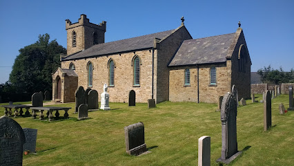
| Description | : | Nestled under an arc of steep-sided hills, Saint Eadmer’s Church occupies a picturesque location in the Forest of Bowland Area of Outstanding Natural Beauty. It is located in the secluded hamlet of Bleasdale. The first church on the site was in fact constructed back in 1577 but it gradually fell into disrepair. Sthe church was rebuilt in 1835 by John Dewhurst and restored/enlarged in 1897. St Eadmer's Church has a unique dedication, celebrating the Northumbrian monk who discovered the site of Durham Cathedral, the final resting place of St Cuthbert of Lindisfarne. |
frequently asked questions (FAQ):
-
Where is St. Eadmer's Churchyard?
St. Eadmer's Churchyard is located at Bleasdale, Wyre Borough, Lancashire, England Bleasdale, Wyre Borough ,Lancashire ,England.
-
St. Eadmer's Churchyard cemetery's updated grave count on graveviews.com?
424 memorials
-
Where are the coordinates of the St. Eadmer's Churchyard?
Latitude: 53.9040530
Longitude: -2.6504390
Nearby Cemetories:
1. Church of St James
Goosnargh, City of Preston, England
Coordinate: 53.8657750, -2.6719410
2. Chipping Congregational Churchyard
Chipping, Ribble Valley Borough, England
Coordinate: 53.8836000, -2.5777700
3. St. Bartholomew Churchyard
Chipping, Ribble Valley Borough, England
Coordinate: 53.8846800, -2.5764100
4. St Thomas Churchyard
Claughton-on-Brock, Wyre Borough, England
Coordinate: 53.8752030, -2.7199160
5. All Saints Parish Churchyard
Barnacre with Bonds, Wyre Borough, England
Coordinate: 53.9079120, -2.7430580
6. St William of York Churchyard
Thornley with Wheatley, Ribble Valley Borough, England
Coordinate: 53.8559540, -2.5866660
7. St. Peter's Churchyard
Garstang, Wyre Borough, England
Coordinate: 53.9309510, -2.7591190
8. St Mary and St Michael Catholic Churchyard
Garstang, Wyre Borough, England
Coordinate: 53.8975610, -2.7706170
9. Garstang United Reformed Churchyard
Garstang, Wyre Borough, England
Coordinate: 53.9026500, -2.7747400
10. St. Thomas Churchyard
Garstang, Wyre Borough, England
Coordinate: 53.8992300, -2.7764500
11. St. Hilda's Churchyard
Bilsborrow, Wyre Borough, England
Coordinate: 53.8522170, -2.7420090
12. St Wilfred Roman Catholic Churchyard Cemetery
Longridge, Ribble Valley Borough, England
Coordinate: 53.8317380, -2.6086060
13. St. Michael's Churchyard
Whitewell, Ribble Valley Borough, England
Coordinate: 53.9167560, -2.5209540
14. St. Mary the Virgin Churchyard
Goosnargh, City of Preston, England
Coordinate: 53.8266470, -2.6707030
15. St Paul's Churchyard
Forton, Wyre Borough, England
Coordinate: 53.9543760, -2.7605890
16. Christ Church Churchyard
Over Wyresdale, City of Lancaster, England
Coordinate: 53.9839250, -2.6861150
17. Whittingham Hospital Cemetery
Goosnargh, City of Preston, England
Coordinate: 53.8208401, -2.6613468
18. St Lawrence Churchyard
Longridge, Ribble Valley Borough, England
Coordinate: 53.8252470, -2.6015030
19. St Hubert Roman Catholic Churchyard
Dunsop Bridge, Ribble Valley Borough, England
Coordinate: 53.9460100, -2.5246900
20. St. Helen's Churchyard
Kirkland (Churchtown), Wyre Borough, England
Coordinate: 53.8790700, -2.7901000
21. St Mark Churchyard
Dolphinholme, City of Lancaster, England
Coordinate: 53.9738730, -2.7378420
22. Knowle Green Congregational Graveyard
Knowle Green, Ribble Valley Borough, England
Coordinate: 53.8380170, -2.5507210
23. Quaker Burial Ground
Abbeystead, City of Lancaster, England
Coordinate: 53.9910820, -2.6912370
24. St. Lawrence Churchyard
Barton, City of Preston, England
Coordinate: 53.8289213, -2.7366654