
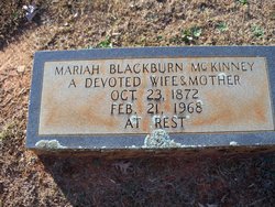
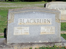
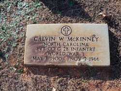
Saloma Mariah Blackburn McKinney
| Birth | : | 23 Oct 1872 North Carolina, USA |
| Death | : | 21 Feb 1968 Forsyth County, North Carolina, USA |
| Burial | : | St. Lawrence's Churchyard, Priddy, Mendip District, England |
| Coordinate | : | 51.2596770, -2.6777600 |
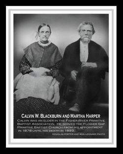
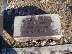
| Description | : | Wife of (1) Garland Huston Vernon, (2) William Gustin McKinney; daughter of Calvin William and Martha (Harper) Blackburn. Link to other children: Rosa Ann Vernon McCraw |
frequently asked questions (FAQ):
-
Where is Saloma Mariah Blackburn McKinney's memorial?
Saloma Mariah Blackburn McKinney's memorial is located at: St. Lawrence's Churchyard, Priddy, Mendip District, England.
-
When did Saloma Mariah Blackburn McKinney death?
Saloma Mariah Blackburn McKinney death on 21 Feb 1968 in Forsyth County, North Carolina, USA
-
Where are the coordinates of the Saloma Mariah Blackburn McKinney's memorial?
Latitude: 51.2596770
Longitude: -2.6777600
Family Members:
Parent
Spouse

Siblings
Children


Nearby Cemetories:
1. St. Lawrence's Churchyard
Priddy, Mendip District, England
Coordinate: 51.2596770, -2.6777600
2. St Lawrence Churchyard
Westbury, Mendip District, England
Coordinate: 51.2354140, -2.7182630
3. St. Leonard's Churchyard
Rodney Stoke, Mendip District, England
Coordinate: 51.2455140, -2.7431800
4. St. Mary's Churchyard
West Harptree, Bath and North East Somerset Unitary Authority, England
Coordinate: 51.3032530, -2.6582110
5. St. Peter's Churchyard
Draycott, Mendip District, England
Coordinate: 51.2580900, -2.7523800
6. St. Matthew Churchyard
Wookey, Mendip District, England
Coordinate: 51.2093000, -2.6893000
7. Wells Cemetery
Wells, Mendip District, England
Coordinate: 51.2088240, -2.6640120
8. St Thomas Churchyard
Wells, Mendip District, England
Coordinate: 51.2132380, -2.6370870
9. Saint Laurence Churchyard
East Harptree, Bath and North East Somerset Unitary Authority, England
Coordinate: 51.3011730, -2.6245740
10. St Michael the Archangel Churchyard
Compton Martin, Bath and North East Somerset Unitary Authority, England
Coordinate: 51.3107380, -2.6534510
11. Wells Cathedral
Wells, Mendip District, England
Coordinate: 51.2103610, -2.6433940
12. St. Cuthbert Churchyard
Wells, Mendip District, England
Coordinate: 51.2080930, -2.6502690
13. Harptree Cemetery
East Harptree, Bath and North East Somerset Unitary Authority, England
Coordinate: 51.3056390, -2.6238890
14. Mendip Hospital Cemetery
Wells, Mendip District, England
Coordinate: 51.2106490, -2.6262980
15. St. Bartholomew Churchyard
Ubley, Bath and North East Somerset Unitary Authority, England
Coordinate: 51.3214600, -2.6766900
16. Christ Church Churchyard
Henton, Mendip District, England
Coordinate: 51.2056460, -2.7256380
17. St. Andrew's Churchyard
Cheddar, Sedgemoor District, England
Coordinate: 51.2736740, -2.7761330
18. St Mary Magdalene Churchyard
Chewton Mendip, Mendip District, England
Coordinate: 51.2760790, -2.5800490
19. Saint John the Evangelist
East Horrington, Mendip District, England
Coordinate: 51.2180000, -2.6006900
20. Cheddar Baptist Burial Ground
Cheddar, Sedgemoor District, England
Coordinate: 51.2767330, -2.7792010
21. Saint Mary the Virgin Churchyard
Litton, Mendip District, England
Coordinate: 51.2899860, -2.5838440
22. Coxley Methodist Churchyard
Coxley, Mendip District, England
Coordinate: 51.1918900, -2.6723700
23. St Andrew Churchyard
Blagdon, North Somerset Unitary Authority, England
Coordinate: 51.3275610, -2.7127710
24. Christ Church Theale
Wedmore, Sedgemoor District, England
Coordinate: 51.2113720, -2.7631570