
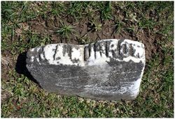
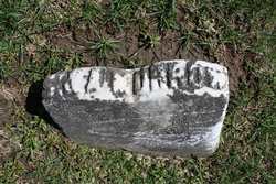
Samuel Morrow
| Birth | : | 1783 Westmoreland County, Pennsylvania, USA |
| Death | : | May 1850 Poweshiek County, Iowa, USA |
| Burial | : | Mojave Cemetery, Mojave, Kern County, USA |
| Coordinate | : | 35.0550117, -118.1694565 |
frequently asked questions (FAQ):
-
Where is Samuel Morrow's memorial?
Samuel Morrow's memorial is located at: Mojave Cemetery, Mojave, Kern County, USA.
-
When did Samuel Morrow death?
Samuel Morrow death on May 1850 in Poweshiek County, Iowa, USA
-
Where are the coordinates of the Samuel Morrow's memorial?
Latitude: 35.0550117
Longitude: -118.1694565
Family Members:
Parent
Spouse
Siblings
Children
Flowers:


Nearby Cemetories:
1. Mojave Cemetery
Mojave, Kern County, USA
Coordinate: 35.0550117, -118.1694565
2. Sand Canyon Cemetery
Tehachapi, Kern County, USA
Coordinate: 35.1331320, -118.3150210
3. James Foley Gravesite
Tehachapi, Kern County, USA
Coordinate: 35.0509590, -118.3561170
4. California City Memorial Park
California City, Kern County, USA
Coordinate: 35.1384080, -117.9275040
5. Tehachapi Eastside Cemetery
Tehachapi, Kern County, USA
Coordinate: 35.1329000, -118.4153200
6. Buhn Ranch Cemetery
Tehachapi, Kern County, USA
Coordinate: 35.1352210, -118.4319290
7. Trier-Pfalzel
Pfalzel, Stadtkreis Trier, Germany
Coordinate: 34.9245895, -117.9339504
8. Tehachapi Westside Cemetery
Tehachapi, Kern County, USA
Coordinate: 35.1387400, -118.4633600
9. Islamic Cemetery and Masjid
Rosamond, Kern County, USA
Coordinate: 34.8385340, -118.3402240
10. Old Tehachapi Cemetery
Tehachapi, Kern County, USA
Coordinate: 35.1400990, -118.4795570
11. Brite Family Cemetery
Tehachapi, Kern County, USA
Coordinate: 35.1085350, -118.5473470
12. Paris-Loraine Cemetery
Loraine, Kern County, USA
Coordinate: 35.3059000, -118.4355000
13. Tehachapi Cove Cemetery
Tehachapi, Kern County, USA
Coordinate: 35.1190000, -118.5724600
14. Josie Bishop Mining Claims and Grave Site
Cantil, Kern County, USA
Coordinate: 35.3803940, -118.0518260
15. Lancaster Cemetery
Lancaster, Los Angeles County, USA
Coordinate: 34.6977806, -118.1286087
16. Cesar E. Chavez National Monument
Keene, Kern County, USA
Coordinate: 35.2236000, -118.5592400
17. Joshua Memorial Park
Lancaster, Los Angeles County, USA
Coordinate: 34.6958008, -118.1141968
18. Good Shepherd Catholic Cemetery
Lancaster, Los Angeles County, USA
Coordinate: 34.6656400, -118.2541300
19. Tejon Indian Settlement Cemetery
Kern County, USA
Coordinate: 35.0422000, -118.6553900
20. Fickert Family Cemetery
Bear Valley Springs, Kern County, USA
Coordinate: 35.1697260, -118.6443350
21. Rankin Cemetery
Walker Basin, Kern County, USA
Coordinate: 35.3844560, -118.5388890
22. Williams Burial Site
Walker Basin, Kern County, USA
Coordinate: 35.4320950, -118.4815680
23. Bakersfield National Cemetery
Arvin, Kern County, USA
Coordinate: 35.2559600, -118.6693480
24. Kelso Cemetery
Weldon, Kern County, USA
Coordinate: 35.5255200, -118.2148500