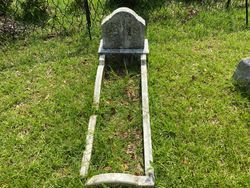
| Birth | : | 5 Nov 1842 Charleston, Charleston County, South Carolina, USA |
| Death | : | 23 May 1915 South Carolina, USA |
| Burial | : | Cosby Cemetery, Cosby, Blaby District, England |
| Coordinate | : | 52.5560490, -1.1962970 |
| Plot | : | Sect.3-P,8 |
| Description | : | Capt. C.S.A.(Co.B, SC Reg) Cpt. Smith served under Maj. Edward Manigault at James Island, SC. He was in charge of the "Siege Train" moving heavy artillery to the coast. A book by Warren Ripley, entitled "Siege Train" contains the diary of Maj. Manigault and frequently references Capt. Smith and his brother Robert Press Smith Jr., and his father Robert Press, Sr. Capt.Porcher Smith was educated at Pineville Academy in SC. In 1857, he entered Jenkins and Coward Military School. 1858, he entered the Arsenal in Columbia and transferred to the Citadel in Charleston, SC the next year. He graduated in 1862. During the Civil... Read More |
frequently asked questions (FAQ):
-
Where is Samuel Porcher Smith's memorial?
Samuel Porcher Smith's memorial is located at: Cosby Cemetery, Cosby, Blaby District, England.
-
When did Samuel Porcher Smith death?
Samuel Porcher Smith death on 23 May 1915 in South Carolina, USA
-
Where are the coordinates of the Samuel Porcher Smith's memorial?
Latitude: 52.5560490
Longitude: -1.1962970
Family Members:
Parent
Spouse
Siblings
Children
Flowers:
Nearby Cemetories:
1. Cosby Cemetery
Cosby, Blaby District, England
Coordinate: 52.5560490, -1.1962970
2. St Michael and All Angels Churchyard
Cosby, Blaby District, England
Coordinate: 52.5488260, -1.1933700
3. All Saints Churchyard
Narborough, Blaby District, England
Coordinate: 52.5730420, -1.2038480
4. Whetstone Cemetery
Whetstone, Blaby District, England
Coordinate: 52.5722900, -1.1779200
5. Saint Peter's Churchyard
Whetstone, Blaby District, England
Coordinate: 52.5727910, -1.1788510
6. Sutton Elms Baptist Chapelyard
Broughton Astley, Harborough District, England
Coordinate: 52.5389370, -1.2328020
7. All Saints Churchyard
Blaby, Blaby District, England
Coordinate: 52.5754960, -1.1600850
8. Blaby Cemetery
Blaby, Blaby District, England
Coordinate: 52.5738950, -1.1541280
9. St Michael & All Angels
Croft, Blaby District, England
Coordinate: 52.5593821, -1.2484472
10. St Marys Parish Churchyard
Broughton Astley, Harborough District, England
Coordinate: 52.5287810, -1.2253600
11. Huncote Cemetery
Huncote, Blaby District, England
Coordinate: 52.5764090, -1.2391220
12. Enderby New Cemetery
Enderby, Blaby District, England
Coordinate: 52.5902330, -1.2048290
13. Enderby Dissenters' Cemetery
Enderby, Blaby District, England
Coordinate: 52.5904190, -1.2049480
14. St John the Baptist Churchyard
Enderby, Blaby District, England
Coordinate: 52.5901570, -1.2077130
15. St Andrew's Churchyard
Countesthorpe, Blaby District, England
Coordinate: 52.5536270, -1.1379810
16. Broughton Astley Cemetery
Broughton Astley, Harborough District, England
Coordinate: 52.5259830, -1.2325190
17. St Mary's Churchyard
Willoughby Waterleys, Harborough District, England
Coordinate: 52.5270920, -1.1532770
18. Countesthorpe Parish Cemetery
Countesthorpe, Blaby District, England
Coordinate: 52.5577540, -1.1309080
19. South Leicestershire Memorial Park and Crematorium
Countesthorpe, Blaby District, England
Coordinate: 52.5562541, -1.1289665
20. Church of All Saints
Dunton Bassett, Harborough District, England
Coordinate: 52.5091000, -1.1946000
21. All Saints Churchyard
Thurlaston, Blaby District, England
Coordinate: 52.5870530, -1.2599600
22. St Michael's Churchyard
Stoney Stanton, Blaby District, England
Coordinate: 52.5487420, -1.2794980
23. Nock Verges Cemetery
Stoney Stanton, Blaby District, England
Coordinate: 52.5492300, -1.2807020
24. St Bartholomew in Foston
Kilby, Blaby District, England
Coordinate: 52.5494780, -1.1117810


