
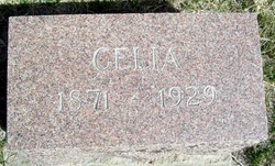
Sara Celia Zeigler Alber
| Birth | : | 11 Feb 1871 Illinois, USA |
| Death | : | 28 Jul 1929 Webster County, Nebraska, USA |
| Burial | : | Frenchtown Cemetery, Frenchtown, Hunterdon County, USA |
| Coordinate | : | 40.5237503, -75.0605545 |
| Plot | : | Section 2 Row 8 |
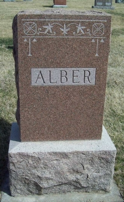
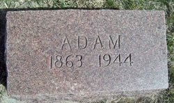
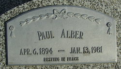
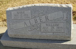
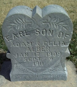
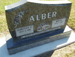
| Description | : | Wife of Adam Alber Parents William Zeigler & Mary Elizabeth Dugger Children Cora, Paul, William, Elizabeth, Henry, Rose, Adolph, Pearl and Roy as well as several children who died young Mary, Jennie, Dorthey, Earl and two infants. |
frequently asked questions (FAQ):
-
Where is Sara Celia Zeigler Alber's memorial?
Sara Celia Zeigler Alber's memorial is located at: Frenchtown Cemetery, Frenchtown, Hunterdon County, USA.
-
When did Sara Celia Zeigler Alber death?
Sara Celia Zeigler Alber death on 28 Jul 1929 in Webster County, Nebraska, USA
-
Where are the coordinates of the Sara Celia Zeigler Alber's memorial?
Latitude: 40.5237503
Longitude: -75.0605545
Family Members:
Parent
Spouse
Siblings

Children
Flowers:


Nearby Cemetories:
1. Frenchtown Cemetery
Frenchtown, Hunterdon County, USA
Coordinate: 40.5237503, -75.0605545
2. Erwin Family Cemetery
Erwinna, Bucks County, USA
Coordinate: 40.5279105, -75.0674030
3. Upper Tinicum Cemetery
Upper Black Eddy, Bucks County, USA
Coordinate: 40.5292650, -75.0822933
4. Baptistown Cemetery
Baptistown, Hunterdon County, USA
Coordinate: 40.5240100, -75.0061190
5. Marshall-Cooper-Ridge Cemetery
Tinicum, Bucks County, USA
Coordinate: 40.4890160, -75.0906330
6. Pursell Burying Ground
Upper Black Eddy, Bucks County, USA
Coordinate: 40.5584410, -75.0933950
7. Oak Summit Cemetery
Kingwood, Hunterdon County, USA
Coordinate: 40.5419000, -75.0051000
8. Everittstown Methodist Cemetery
Everittstown, Hunterdon County, USA
Coordinate: 40.5655823, -75.0279922
9. Milford Union Cemetery
Milford, Hunterdon County, USA
Coordinate: 40.5667000, -75.0922012
10. Rock Ridge Chapel Cemetery
Upper Black Eddy, Bucks County, USA
Coordinate: 40.5010986, -75.1181030
11. Milford Christian Churchyard
Milford, Hunterdon County, USA
Coordinate: 40.5685425, -75.0972214
12. Stewart Cemetery
Tinicum, Bucks County, USA
Coordinate: 40.5148430, -75.1368700
13. Mount Pleasant Cemetery
Mount Pleasant, Hunterdon County, USA
Coordinate: 40.5835267, -75.0536867
14. Slacktown Cemetery
Kingwood, Hunterdon County, USA
Coordinate: 40.5102778, -74.9797222
15. Saint Thomas Episcopal Church Cemetery
Pittstown, Hunterdon County, USA
Coordinate: 40.5606900, -74.9890000
16. Hillpot Cemetery
Tinicum, Bucks County, USA
Coordinate: 40.4561005, -75.1082993
17. Old School Baptist Cemetery
Locktown, Hunterdon County, USA
Coordinate: 40.4844290, -74.9725060
18. Lower Tinicum Union Cemetery
Tinicum, Bucks County, USA
Coordinate: 40.4531000, -75.1050000
19. Locktown Christian Cemetery
Locktown, Hunterdon County, USA
Coordinate: 40.4820137, -74.9694443
20. Methodist Episcopal Church Cemetery
Kingwood, Hunterdon County, USA
Coordinate: 40.4508800, -75.0097800
21. Oak Hill Golf Course Burial Ground
Holland, Hunterdon County, USA
Coordinate: 40.6061170, -75.1085940
22. Red Hill Saint Lukes UCC Cemetery
Ottsville, Bucks County, USA
Coordinate: 40.4693000, -75.1577000
23. Nockamixon Union Cemetery
Ferndale, Bucks County, USA
Coordinate: 40.5314903, -75.1812820
24. Saint Luke's Evangelical Lutheran Church Cemetery
Ferndale, Bucks County, USA
Coordinate: 40.5290000, -75.1835000