
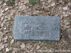
Sarah Jane McNutt Long
| Birth | : | 14 May 1833 Ohio, USA |
| Death | : | 29 Apr 1908 Big Timber, Sweet Grass County, Montana, USA |
| Burial | : | Mound Grove Cemetery, Independence, Jackson County, USA |
| Coordinate | : | 39.1128006, -94.4281006 |
| Plot | : | Section 6, Block 12, Lot 3, Grave 6 |
| Description | : | Suggested edit: Mother: Catherine Brown This information is from the Death Certificate and was provided by the Informant: J.L. Long Contributor: Donna Harkness (49618312) Big Timber Pioneer, May 7, 1908 Grandmother Long Laid To Rest On last Friday, May 1, one of the largest funeral assemblies in Big Timber gathered at the Congregational church to show their esteem of a worthy life. It was "grandmother Long" this time, beloved of all who knew her. She was born in Seneca county, Ohio, May 14th, 1833. A few days more added to her life and she would have celebrated her... Read More |
frequently asked questions (FAQ):
-
Where is Sarah Jane McNutt Long's memorial?
Sarah Jane McNutt Long's memorial is located at: Mound Grove Cemetery, Independence, Jackson County, USA.
-
When did Sarah Jane McNutt Long death?
Sarah Jane McNutt Long death on 29 Apr 1908 in Big Timber, Sweet Grass County, Montana, USA
-
Where are the coordinates of the Sarah Jane McNutt Long's memorial?
Latitude: 39.1128006
Longitude: -94.4281006
Family Members:
Parent
Spouse
Siblings
Children


Nearby Cemetories:
1. Mound Grove Cemetery
Independence, Jackson County, USA
Coordinate: 39.1128006, -94.4281006
2. Harry S. Truman Library and Museum
Independence, Jackson County, USA
Coordinate: 39.1035200, -94.4213900
3. Trinity Episcopal Church Columbarium
Independence, Jackson County, USA
Coordinate: 39.0952300, -94.4166400
4. Long Cemetery
Independence, Jackson County, USA
Coordinate: 39.1284700, -94.4097700
5. Tucker Cemetery
Independence, Jackson County, USA
Coordinate: 39.1224300, -94.4021600
6. Reed Cemetery
Independence, Jackson County, USA
Coordinate: 39.1097400, -94.4593900
7. Hedrick Cemetery
Independence, Jackson County, USA
Coordinate: 39.1072006, -94.3914032
8. Woodlawn Cemetery
Independence, Jackson County, USA
Coordinate: 39.0856018, -94.4107971
9. Hill Park Cemetery
Independence, Jackson County, USA
Coordinate: 39.0835991, -94.4539032
10. Staples Family Cemetery
East Independence, Jackson County, USA
Coordinate: 39.1201400, -94.3797800
11. Smiley Cemetery
Sugar Creek, Jackson County, USA
Coordinate: 39.1411000, -94.3941900
12. Mount Washington Cemetery
Independence, Jackson County, USA
Coordinate: 39.0957985, -94.4757996
13. Mann Cemetery
Sugar Creek, Jackson County, USA
Coordinate: 39.1511002, -94.4002991
14. Lincoln Cemetery
Kansas City, Jackson County, USA
Coordinate: 39.0946999, -94.4805984
15. Kehilath Israel Blue Ridge Cemetery
Independence, Jackson County, USA
Coordinate: 39.0875015, -94.4766998
16. Highland Cemetery
Kansas City, Jackson County, USA
Coordinate: 39.0853004, -94.4760971
17. Blue Ridge Lawn Memorial Gardens
Kansas City, Jackson County, USA
Coordinate: 39.0760002, -94.4717026
18. Oak Ridge Memory Gardens
Independence, Jackson County, USA
Coordinate: 39.1046982, -94.3638992
19. Pitcher Cemetery
Independence, Jackson County, USA
Coordinate: 39.0635986, -94.4702988
20. Minneville Cemetery
Minaville, Clay County, USA
Coordinate: 39.1671906, -94.4616928
21. Sheffield Cemetery
Kansas City, Jackson County, USA
Coordinate: 39.1082993, -94.5083008
22. Webb Cemetery
Independence, Jackson County, USA
Coordinate: 39.1138600, -94.3403200
23. Lewis-Gregg Cemetery
Independence, Jackson County, USA
Coordinate: 39.1454700, -94.3467400
24. Luttrell Cemetery
Independence, Jackson County, USA
Coordinate: 39.0504700, -94.3839300