
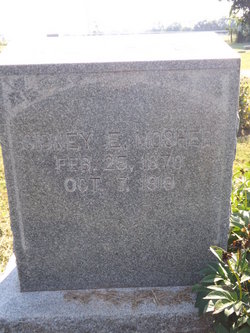

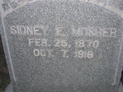
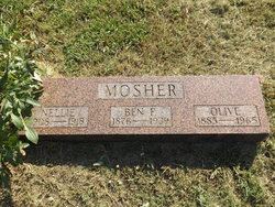
Sidney E. Mosher
| Birth | : | 25 Feb 1870 Leavenworth County, Kansas, USA |
| Death | : | 7 Oct 1918 |
| Burial | : | Lower Amwell Cemetery - New Yard, Sergeantsville, Hunterdon County, USA |
| Coordinate | : | 40.4475098, -74.9133453 |
| Description | : | Sidney Moshier, a farmer living between Larkinburg and Arrington, shot and instantly killed himself early Monday morning at his home. Mr. Moshier had been under considerable mental strain for some time, cholera had taken his hogs, help was hard to get on the farm and his only boy was in the next draft. He worried extremely about his son’s going to war and his own need for the boy on the farm ... He leaves a widow and two grown children, a son and a daughter ... The Holton Recorder, October 10, 1918. Arrington. .... laid to rest in... Read More |
frequently asked questions (FAQ):
-
Where is Sidney E. Mosher's memorial?
Sidney E. Mosher's memorial is located at: Lower Amwell Cemetery - New Yard, Sergeantsville, Hunterdon County, USA.
-
When did Sidney E. Mosher death?
Sidney E. Mosher death on 7 Oct 1918 in
-
Where are the coordinates of the Sidney E. Mosher's memorial?
Latitude: 40.4475098
Longitude: -74.9133453
Family Members:
Parent
Siblings

Children
Flowers:


Nearby Cemetories:
1. Lower Amwell Cemetery - New Yard
Sergeantsville, Hunterdon County, USA
Coordinate: 40.4475098, -74.9133453
2. Lower Amwell Cemetery - Old Yard
Sergeantsville, Hunterdon County, USA
Coordinate: 40.4479866, -74.9134750
3. Moore Family Burying Ground
Sergeantsville, Hunterdon County, USA
Coordinate: 40.4414400, -74.9008720
4. Rake Family Burying Ground
Sand Brook, Hunterdon County, USA
Coordinate: 40.4598999, -74.9170914
5. Opdycke Cemetery
Hunterdon County, USA
Coordinate: 40.4375000, -74.9250000
6. Sand Brook German Baptist Church Cemetery
Sand Brook, Hunterdon County, USA
Coordinate: 40.4687500, -74.9162216
7. Sutton Farm Cemetery
Hunterdon County, USA
Coordinate: 40.4737206, -74.9048309
8. Barber Burying Ground
Sandy Ridge, Hunterdon County, USA
Coordinate: 40.4190292, -74.9282608
9. Sergeantville Methodist Episcopal Church Cemetery
Sergeantsville, Hunterdon County, USA
Coordinate: 40.4458333, -74.9538880
10. Saint Andrews Episcopal Churchyard
Ringoes, Hunterdon County, USA
Coordinate: 40.4406586, -74.8734360
11. Trout Family Burying Ground
Sand Brook, Hunterdon County, USA
Coordinate: 40.4777778, -74.8972222
12. Servis-Quick Family Cemetery
Ringoes, Hunterdon County, USA
Coordinate: 40.4375000, -74.8722220
13. Kitchen Cemetery
Sand Brook, Hunterdon County, USA
Coordinate: 40.4803810, -74.9092480
14. Union Cemetery
Ringoes, Hunterdon County, USA
Coordinate: 40.4261017, -74.8732986
15. Pine Hill Cemetery
Sergeantsville, Hunterdon County, USA
Coordinate: 40.4580498, -74.9622192
16. Sandy Ridge Cemetery
Sandy Ridge, Hunterdon County, USA
Coordinate: 40.4232178, -74.9541168
17. Geary Gravesite
Amwell, Hunterdon County, USA
Coordinate: 40.4561386, -74.8564301
18. Amwell Ridge Cemetery
Ringoes, Hunterdon County, USA
Coordinate: 40.4415970, -74.8554840
19. Second English Presbyterian Church Cemetery
Amwell, Hunterdon County, USA
Coordinate: 40.3984718, -74.9072189
20. Carmelite Monastery Cemetery
Flemington, Hunterdon County, USA
Coordinate: 40.4976610, -74.8980680
21. Williamson Farm Family Cemetery
Stockton, Hunterdon County, USA
Coordinate: 40.4457220, -74.9818690
22. Locktown Christian Cemetery
Locktown, Hunterdon County, USA
Coordinate: 40.4820137, -74.9694443
23. Valley School Cemetery
Hunterdon County, USA
Coordinate: 40.4981500, -74.8814430
24. Old School Baptist Cemetery
Locktown, Hunterdon County, USA
Coordinate: 40.4844290, -74.9725060