
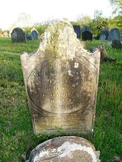

Thomas B Sweet
| Birth | : | 14 Jul 1794 Lebanon, New London County, Connecticut, USA |
| Death | : | 27 Apr 1813 Lebanon, New London County, Connecticut, USA |
| Burial | : | Fort Steuben Burial Estates, Wintersville, Jefferson County, USA |
| Coordinate | : | 40.3891983, -80.7236023 |
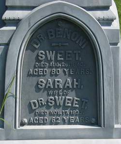
| Description | : | son of Dr. Benoni & Sarah Sweet aged 18 years |
frequently asked questions (FAQ):
-
Where is Thomas B Sweet's memorial?
Thomas B Sweet's memorial is located at: Fort Steuben Burial Estates, Wintersville, Jefferson County, USA.
-
When did Thomas B Sweet death?
Thomas B Sweet death on 27 Apr 1813 in Lebanon, New London County, Connecticut, USA
-
Where are the coordinates of the Thomas B Sweet's memorial?
Latitude: 40.3891983
Longitude: -80.7236023
Family Members:
Parent

Siblings
Flowers:


Nearby Cemetories:
1. Fort Steuben Burial Estates
Wintersville, Jefferson County, USA
Coordinate: 40.3891983, -80.7236023
2. Two Ridges Cemetery
Wintersville, Jefferson County, USA
Coordinate: 40.3944016, -80.7328033
3. Wintersville United Methodist Church Cemetery
Wintersville, Jefferson County, USA
Coordinate: 40.3755360, -80.7064440
4. Coulter Cemetery
Wintersville, Jefferson County, USA
Coordinate: 40.4000970, -80.7014690
5. Carne Cemetery
Salem Township, Jefferson County, USA
Coordinate: 40.4089012, -80.7667007
6. Jefferson County Infirmary Cemetery
Steubenville, Jefferson County, USA
Coordinate: 40.3748880, -80.6725990
7. Center Chapel Cemetery
Island Creek Township, Jefferson County, USA
Coordinate: 40.4276600, -80.6942300
8. Cross Creek Cemetery
Wintersville, Jefferson County, USA
Coordinate: 40.3492928, -80.6872635
9. Holy Resurrection Serbian Eastern Orthodox Church
Steubenville, Jefferson County, USA
Coordinate: 40.3760986, -80.6580963
10. Bnai Israel Cemetery
Steubenville, Jefferson County, USA
Coordinate: 40.3744011, -80.6572037
11. Richmond United Presbyterian Cemetery
Salem Township, Jefferson County, USA
Coordinate: 40.4310989, -80.7680969
12. Quaker Cemetery
Richmond, Jefferson County, USA
Coordinate: 40.4112680, -80.7883450
13. Methodist-Episcopal Cemetery
Richmond, Jefferson County, USA
Coordinate: 40.4317460, -80.7709400
14. Richmond Union Cemetery
Richmond, Jefferson County, USA
Coordinate: 40.4289017, -80.7763977
15. Mount Tabor Methodist Church Cemetery
Richmond, Jefferson County, USA
Coordinate: 40.4519997, -80.7286987
16. Mount Calvary Cemetery
Steubenville, Jefferson County, USA
Coordinate: 40.3643990, -80.6466980
17. Queen of All Saints Cemetery
Bloomingdale, Jefferson County, USA
Coordinate: 40.3841050, -80.8094450
18. Union Cemetery
Steubenville, Jefferson County, USA
Coordinate: 40.3636017, -80.6399994
19. Longs Methodist Episcopal Cemetery
Jefferson County, USA
Coordinate: 40.3203400, -80.7400100
20. Saint James Episcopal Cemetery
Cross Creek Township, Jefferson County, USA
Coordinate: 40.3211700, -80.7563400
21. Mount Hope Cemetery
Salem Township, Jefferson County, USA
Coordinate: 40.4075012, -80.8182983
22. Holy Family Hermitage Cemetery
Bloomingdale, Jefferson County, USA
Coordinate: 40.3840650, -80.8243020
23. Tomb of the Unborn Child
Steubenville, Jefferson County, USA
Coordinate: 40.3753230, -80.6199840
24. Bloomingdale Cemetery
Bloomingdale, Jefferson County, USA
Coordinate: 40.3418110, -80.8134230