
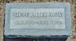
Velmar Albert Robey
| Birth | : | 21 Feb 1930 Newton, Harvey County, Kansas, USA |
| Death | : | 7 Jun 1956 Parsons, Labette County, Kansas, USA |
| Burial | : | Mount Calvary Cemetery, Topeka, Shawnee County, USA |
| Coordinate | : | 39.0532990, -95.7360992 |
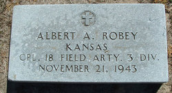
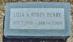
| Description | : | Adopted son of Lilia Birt and Albert A. Robey. ____ The Parsons Sun Parsons, KS Thursday Evening, June 7, 1956 Page 1, Column 3 Death from Ensilage Gas Ensilage gas in a partly filled silo claimed the life of a 27-year-old farm worker today. Two others were partly overcome. Velmar Robey, a student at the Parsons State Training School, was pronounced dead shortly after he was removed from a silo at the W. H. Burkhall farm home three miles south of Parsons. Robey, had been employed at the Burkhall farm two years. Burkhall,... Read More |
frequently asked questions (FAQ):
-
Where is Velmar Albert Robey's memorial?
Velmar Albert Robey's memorial is located at: Mount Calvary Cemetery, Topeka, Shawnee County, USA.
-
When did Velmar Albert Robey death?
Velmar Albert Robey death on 7 Jun 1956 in Parsons, Labette County, Kansas, USA
-
Where are the coordinates of the Velmar Albert Robey's memorial?
Latitude: 39.0532990
Longitude: -95.7360992
Family Members:
Parent
Flowers:


Nearby Cemetories:
1. Mount Calvary Cemetery
Topeka, Shawnee County, USA
Coordinate: 39.0532990, -95.7360992
2. Memorial Park Cemetery
Topeka, Shawnee County, USA
Coordinate: 39.0619011, -95.7221985
3. Mount Hope Cemetery
Topeka, Shawnee County, USA
Coordinate: 39.0367393, -95.7386703
4. Saint Davids Episcopal Church Columbarium
Topeka, Shawnee County, USA
Coordinate: 39.0369860, -95.7259480
5. Security Benefit Association Cemetery
Topeka, Shawnee County, USA
Coordinate: 39.0630989, -95.7606583
6. Topeka State Hospital Cemetery
Topeka, Shawnee County, USA
Coordinate: 39.0671005, -95.7080994
7. Westminster Presbyterian Church Memorial Garden
Topeka, Shawnee County, USA
Coordinate: 39.0430400, -95.7021700
8. Carnegie Hall
Topeka, Shawnee County, USA
Coordinate: 39.0350600, -95.6999100
9. Ritchie Cemetery
Topeka, Shawnee County, USA
Coordinate: 39.0228010, -95.7027530
10. Grace Episcopal Cathedral Columbarium
Topeka, Shawnee County, USA
Coordinate: 39.0511284, -95.6843719
11. Grace Episcopal Cathedral Sanctuary
Topeka, Shawnee County, USA
Coordinate: 39.0506925, -95.6839273
12. Abram Burnett Burial Site
Topeka, Shawnee County, USA
Coordinate: 39.0102997, -95.7685776
13. Mission Center Cemetery
Topeka, Shawnee County, USA
Coordinate: 39.0145493, -95.7819290
14. Prairie Home Cemetery
Topeka, Shawnee County, USA
Coordinate: 39.1077118, -95.7482910
15. Curtis Family Cemetery
North Topeka, Shawnee County, USA
Coordinate: 39.0792870, -95.6702270
16. West Lawn Memorial Gardens
Topeka, Shawnee County, USA
Coordinate: 39.0518112, -95.8167419
17. Bennie Lee Graham Memorial Cemetery
Shawnee County, USA
Coordinate: 39.1020584, -95.6836472
18. Foster Cemetery
Topeka, Shawnee County, USA
Coordinate: 38.9942017, -95.7061005
19. Topeka Cemetery
Topeka, Shawnee County, USA
Coordinate: 39.0388985, -95.6528015
20. Rochester Cemetery
Topeka, Shawnee County, USA
Coordinate: 39.1044006, -95.6800003
21. Mount Auburn Cemetery
Topeka, Shawnee County, USA
Coordinate: 39.0393982, -95.6500015
22. Elevation Cemetery
Shawnee County, USA
Coordinate: 38.9832993, -95.7613983
23. Half-Day Cemetery
Elmont, Shawnee County, USA
Coordinate: 39.1584702, -95.7143402
24. Valencia Cemetery
Valencia, Shawnee County, USA
Coordinate: 39.0586014, -95.8806000