
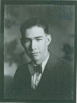

Vernon Albert Cline
| Birth | : | 23 Apr 1910 Hamilton County, Nebraska, USA |
| Death | : | 20 Jan 1998 Stromsburg, Polk County, Nebraska, USA |
| Burial | : | Silver City Cemetery, Silver City, Mills County, USA |
| Coordinate | : | 41.1042442, -95.6380005 |
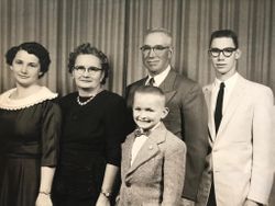
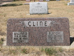
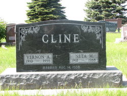
| Description | : | Vernon Albert Cline, the son of William and Blanche (Chambers) Cline, was born in Hamilton County, Nebraska, on April 23, 1910, and died at Stromsburg, Nebraska, on January 20, 1998, at the age of 87 years, 8 months, and 27 days. He grew up and received his education near Phillips, and graduated from Phillips High School. On August 14, 1938, he was united in marriage to Neta Lantzer at Aurora. She preceded him in death on January 16, 1988. They farmed in York and Box Butte Counties for many years, moving to Aurora in 1968. He worked... Read More |
frequently asked questions (FAQ):
-
Where is Vernon Albert Cline's memorial?
Vernon Albert Cline's memorial is located at: Silver City Cemetery, Silver City, Mills County, USA.
-
When did Vernon Albert Cline death?
Vernon Albert Cline death on 20 Jan 1998 in Stromsburg, Polk County, Nebraska, USA
-
Where are the coordinates of the Vernon Albert Cline's memorial?
Latitude: 41.1042442
Longitude: -95.6380005
Family Members:
Parent

Spouse
Siblings

Children
Flowers:


Nearby Cemetories:
1. Silver City Cemetery
Silver City, Mills County, USA
Coordinate: 41.1042442, -95.6380005
2. East Liberty Cemetery
Malvern, Mills County, USA
Coordinate: 41.0592346, -95.6005020
3. Mineola Cemetery
Mineola, Mills County, USA
Coordinate: 41.1391130, -95.6941800
4. Mills County Farm Cemetery
Glenwood, Mills County, USA
Coordinate: 41.0417930, -95.6756530
5. Bomar Family Cemetery
Mills County, USA
Coordinate: 41.0369400, -95.6941700
6. West Liberty Cemetery
Glenwood, Mills County, USA
Coordinate: 41.0956001, -95.7536011
7. Saint Boniface Catholic Cemetery
Mills County, USA
Coordinate: 41.1419000, -95.7467100
8. Glenwood Catholic Cemetery
Glenwood, Mills County, USA
Coordinate: 41.0600000, -95.7453000
9. Cotten Cemetery
Mills County, USA
Coordinate: 41.0845000, -95.5167000
10. Glenwood Cemetery
Glenwood, Mills County, USA
Coordinate: 41.0599670, -95.7480240
11. Hillsdale Cemetery
Glenwood, Mills County, USA
Coordinate: 41.0097008, -95.6427994
12. Keg Creek Township Cemetery
Treynor, Pottawattamie County, USA
Coordinate: 41.1913986, -95.6893997
13. Glenwood Resource Center Cemetery
Glenwood, Mills County, USA
Coordinate: 41.0361720, -95.7338590
14. Zion Cemetery
Pottawattamie County, USA
Coordinate: 41.1778000, -95.7272000
15. Wearin Cemetery
Malvern, Mills County, USA
Coordinate: 41.0395000, -95.5313000
16. Saar's Field Cemetery
Mills County, USA
Coordinate: 41.1255500, -95.7725000
17. Wesley Chapel Cemetery
Henderson, Mills County, USA
Coordinate: 41.1019249, -95.4987793
18. Salem Lutheran Church Cemetery
Glenwood, Mills County, USA
Coordinate: 41.1556015, -95.7617035
19. Saint Pauls Evangelical Country Church Cemetery
Dumfries, Pottawattamie County, USA
Coordinate: 41.1748352, -95.7492371
20. Saylers Farm Cemetery
Henderson, Mills County, USA
Coordinate: 41.1083300, -95.4919440
21. Gowens-Turner Cemetery
Glenwood, Mills County, USA
Coordinate: 41.0715510, -95.7952420
22. Malvern Cemetery
Malvern, Mills County, USA
Coordinate: 40.9886017, -95.5785980
23. Saint Paul Lutheran Cemetery
Treynor, Pottawattamie County, USA
Coordinate: 41.2322000, -95.6380000
24. Zion Congregational Cemetery
Treynor, Pottawattamie County, USA
Coordinate: 41.2325090, -95.6079200