
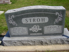
Vernon P. Stroh
| Birth | : | 5 Jun 1925 Webster County, Nebraska, USA |
| Death | : | 11 Mar 1989 USA |
| Burial | : | Amwell Ridge Cemetery, Ringoes, Hunterdon County, USA |
| Coordinate | : | 40.4415970, -74.8554840 |
| Plot | : | Buss section Lot 20 |
frequently asked questions (FAQ):
-
Where is Vernon P. Stroh's memorial?
Vernon P. Stroh's memorial is located at: Amwell Ridge Cemetery, Ringoes, Hunterdon County, USA.
-
When did Vernon P. Stroh death?
Vernon P. Stroh death on 11 Mar 1989 in USA
-
Where are the coordinates of the Vernon P. Stroh's memorial?
Latitude: 40.4415970
Longitude: -74.8554840
Family Members:
Parent
Spouse

Siblings
Flowers:


Nearby Cemetories:
1. Amwell Ridge Cemetery
Ringoes, Hunterdon County, USA
Coordinate: 40.4415970, -74.8554840
2. Servis-Quick Family Cemetery
Ringoes, Hunterdon County, USA
Coordinate: 40.4375000, -74.8722220
3. Saint Andrews Episcopal Churchyard
Ringoes, Hunterdon County, USA
Coordinate: 40.4406586, -74.8734360
4. Geary Gravesite
Amwell, Hunterdon County, USA
Coordinate: 40.4561386, -74.8564301
5. Union Cemetery
Ringoes, Hunterdon County, USA
Coordinate: 40.4261017, -74.8732986
6. Pleasant Ridge Cemetery
Ringoes, Hunterdon County, USA
Coordinate: 40.4578018, -74.8336029
7. Moore Family Burying Ground
Sergeantsville, Hunterdon County, USA
Coordinate: 40.4414400, -74.9008720
8. Lower Amwell Cemetery - New Yard
Sergeantsville, Hunterdon County, USA
Coordinate: 40.4475098, -74.9133453
9. Lower Amwell Cemetery - Old Yard
Sergeantsville, Hunterdon County, USA
Coordinate: 40.4479866, -74.9134750
10. Rockefeller-Wikoff Burying Ground
Rocktown, Hunterdon County, USA
Coordinate: 40.3978424, -74.8675385
11. Wertsville Baptist Churchyard
Ringoes, Hunterdon County, USA
Coordinate: 40.4586110, -74.7977770
12. Trout Family Burying Ground
Sand Brook, Hunterdon County, USA
Coordinate: 40.4777778, -74.8972222
13. Sutton Farm Cemetery
Hunterdon County, USA
Coordinate: 40.4737206, -74.9048309
14. Rake Family Burying Ground
Sand Brook, Hunterdon County, USA
Coordinate: 40.4598999, -74.9170914
15. Opdycke Cemetery
Hunterdon County, USA
Coordinate: 40.4375000, -74.9250000
16. Sand Brook German Baptist Church Cemetery
Sand Brook, Hunterdon County, USA
Coordinate: 40.4687500, -74.9162216
17. Stout-Manners Cemetery
Ringoes, Hunterdon County, USA
Coordinate: 40.4586110, -74.7855550
18. Kitchen Cemetery
Sand Brook, Hunterdon County, USA
Coordinate: 40.4803810, -74.9092480
19. Second English Presbyterian Church Cemetery
Amwell, Hunterdon County, USA
Coordinate: 40.3984718, -74.9072189
20. Barber Burying Ground
Sandy Ridge, Hunterdon County, USA
Coordinate: 40.4190292, -74.9282608
21. Valley School Cemetery
Hunterdon County, USA
Coordinate: 40.4981500, -74.8814430
22. Winder Phillips Grave Yard
Mount Airy, Hunterdon County, USA
Coordinate: 40.3847222, -74.8833333
23. Rocks Methodist Episcopal Cemetery
Mount Airy, Hunterdon County, USA
Coordinate: 40.3844986, -74.8835983
24. Flemington Baptist Churchyard
Flemington, Hunterdon County, USA
Coordinate: 40.5058327, -74.8572235