
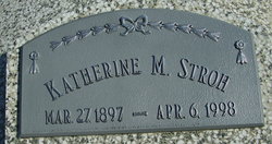
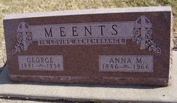
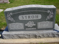
Katherine Margaret Benker Stroh
| Birth | : | 27 Mar 1897 Webster County, Nebraska, USA |
| Death | : | 6 Apr 1998 Lincoln, Lancaster County, Nebraska, USA |
| Burial | : | Amwell Ridge Cemetery, Ringoes, Hunterdon County, USA |
| Coordinate | : | 40.4415970, -74.8554840 |
| Plot | : | Buss section Lot 20 |
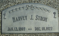
| Description | : | Katherine Stroh Katherine Margaret Stroh, daughter of John and Margareta (Wunschel) Benker was born March 27, 1897, on a farm near Rosemont, Nebraska. She was baptized in the Lutheran Faith as an infant and confirmed at Zion Lutheran Church near Lawrence on Palm Sunday, April 5, 1914. On February 20, 1919, she was united in marriage to Harvey J. Stroh, by Rev. C.F. Schrein at Zion Lutheran parsonage. They lived on a farm three miles south of Rosemont until 1961, when they retired and moved to Blue Hill. They observed the 50th anniversary of their marriage in 1969 and... Read More |
frequently asked questions (FAQ):
-
Where is Katherine Margaret Benker Stroh's memorial?
Katherine Margaret Benker Stroh's memorial is located at: Amwell Ridge Cemetery, Ringoes, Hunterdon County, USA.
-
When did Katherine Margaret Benker Stroh death?
Katherine Margaret Benker Stroh death on 6 Apr 1998 in Lincoln, Lancaster County, Nebraska, USA
-
Where are the coordinates of the Katherine Margaret Benker Stroh's memorial?
Latitude: 40.4415970
Longitude: -74.8554840
Family Members:
Parent
Spouse
Siblings

Children
Flowers:


Nearby Cemetories:
1. Amwell Ridge Cemetery
Ringoes, Hunterdon County, USA
Coordinate: 40.4415970, -74.8554840
2. Servis-Quick Family Cemetery
Ringoes, Hunterdon County, USA
Coordinate: 40.4375000, -74.8722220
3. Saint Andrews Episcopal Churchyard
Ringoes, Hunterdon County, USA
Coordinate: 40.4406586, -74.8734360
4. Geary Gravesite
Amwell, Hunterdon County, USA
Coordinate: 40.4561386, -74.8564301
5. Union Cemetery
Ringoes, Hunterdon County, USA
Coordinate: 40.4261017, -74.8732986
6. Pleasant Ridge Cemetery
Ringoes, Hunterdon County, USA
Coordinate: 40.4578018, -74.8336029
7. Moore Family Burying Ground
Sergeantsville, Hunterdon County, USA
Coordinate: 40.4414400, -74.9008720
8. Lower Amwell Cemetery - New Yard
Sergeantsville, Hunterdon County, USA
Coordinate: 40.4475098, -74.9133453
9. Lower Amwell Cemetery - Old Yard
Sergeantsville, Hunterdon County, USA
Coordinate: 40.4479866, -74.9134750
10. Rockefeller-Wikoff Burying Ground
Rocktown, Hunterdon County, USA
Coordinate: 40.3978424, -74.8675385
11. Wertsville Baptist Churchyard
Ringoes, Hunterdon County, USA
Coordinate: 40.4586110, -74.7977770
12. Trout Family Burying Ground
Sand Brook, Hunterdon County, USA
Coordinate: 40.4777778, -74.8972222
13. Sutton Farm Cemetery
Hunterdon County, USA
Coordinate: 40.4737206, -74.9048309
14. Rake Family Burying Ground
Sand Brook, Hunterdon County, USA
Coordinate: 40.4598999, -74.9170914
15. Opdycke Cemetery
Hunterdon County, USA
Coordinate: 40.4375000, -74.9250000
16. Sand Brook German Baptist Church Cemetery
Sand Brook, Hunterdon County, USA
Coordinate: 40.4687500, -74.9162216
17. Stout-Manners Cemetery
Ringoes, Hunterdon County, USA
Coordinate: 40.4586110, -74.7855550
18. Kitchen Cemetery
Sand Brook, Hunterdon County, USA
Coordinate: 40.4803810, -74.9092480
19. Second English Presbyterian Church Cemetery
Amwell, Hunterdon County, USA
Coordinate: 40.3984718, -74.9072189
20. Barber Burying Ground
Sandy Ridge, Hunterdon County, USA
Coordinate: 40.4190292, -74.9282608
21. Valley School Cemetery
Hunterdon County, USA
Coordinate: 40.4981500, -74.8814430
22. Winder Phillips Grave Yard
Mount Airy, Hunterdon County, USA
Coordinate: 40.3847222, -74.8833333
23. Rocks Methodist Episcopal Cemetery
Mount Airy, Hunterdon County, USA
Coordinate: 40.3844986, -74.8835983
24. Flemington Baptist Churchyard
Flemington, Hunterdon County, USA
Coordinate: 40.5058327, -74.8572235