
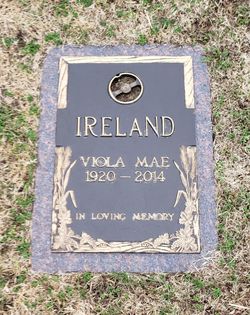

Viola Mae Ruth Ireland
| Birth | : | 17 Oct 1920 Circleville, Jackson County, Kansas, USA |
| Death | : | 20 Jul 2014 Topeka, Shawnee County, Kansas, USA |
| Burial | : | Memorial Park Cemetery, Topeka, Shawnee County, USA |
| Coordinate | : | 39.0619011, -95.7221985 |
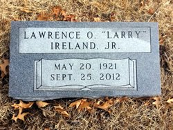
| Description | : | Viola Mae Ireland passed away Sunday, July 20, 2014 at McCrite Plaza Retirement Community in Topeka, Kansas. Viola was born October 17, 1920 in Circleville, Kansas to James Ruth and Anna Swain Ruth. Viola was the youngest of eleven children. She graduated from Circleville High School in 1938. Viola married Lawrence O. Ireland in 1941 and lived in Holton, Kansas until 1959 when they moved to Topeka. They later divorced. Viola worked for the District Court Trustee office in Shawnee County and retired in 2005. She was a member of Crestview United Methodist Church. Viola was a member and past... Read More |
frequently asked questions (FAQ):
-
Where is Viola Mae Ruth Ireland's memorial?
Viola Mae Ruth Ireland's memorial is located at: Memorial Park Cemetery, Topeka, Shawnee County, USA.
-
When did Viola Mae Ruth Ireland death?
Viola Mae Ruth Ireland death on 20 Jul 2014 in Topeka, Shawnee County, Kansas, USA
-
Where are the coordinates of the Viola Mae Ruth Ireland's memorial?
Latitude: 39.0619011
Longitude: -95.7221985
Family Members:
Parent
Spouse
Siblings
Flowers:


Nearby Cemetories:
1. Memorial Park Cemetery
Topeka, Shawnee County, USA
Coordinate: 39.0619011, -95.7221985
2. Topeka State Hospital Cemetery
Topeka, Shawnee County, USA
Coordinate: 39.0671005, -95.7080994
3. Mount Calvary Cemetery
Topeka, Shawnee County, USA
Coordinate: 39.0532990, -95.7360992
4. Westminster Presbyterian Church Memorial Garden
Topeka, Shawnee County, USA
Coordinate: 39.0430400, -95.7021700
5. Saint Davids Episcopal Church Columbarium
Topeka, Shawnee County, USA
Coordinate: 39.0369860, -95.7259480
6. Mount Hope Cemetery
Topeka, Shawnee County, USA
Coordinate: 39.0367393, -95.7386703
7. Security Benefit Association Cemetery
Topeka, Shawnee County, USA
Coordinate: 39.0630989, -95.7606583
8. Grace Episcopal Cathedral Columbarium
Topeka, Shawnee County, USA
Coordinate: 39.0511284, -95.6843719
9. Grace Episcopal Cathedral Sanctuary
Topeka, Shawnee County, USA
Coordinate: 39.0506925, -95.6839273
10. Carnegie Hall
Topeka, Shawnee County, USA
Coordinate: 39.0350600, -95.6999100
11. Ritchie Cemetery
Topeka, Shawnee County, USA
Coordinate: 39.0228010, -95.7027530
12. Curtis Family Cemetery
North Topeka, Shawnee County, USA
Coordinate: 39.0792870, -95.6702270
13. Bennie Lee Graham Memorial Cemetery
Shawnee County, USA
Coordinate: 39.1020584, -95.6836472
14. Prairie Home Cemetery
Topeka, Shawnee County, USA
Coordinate: 39.1077118, -95.7482910
15. Rochester Cemetery
Topeka, Shawnee County, USA
Coordinate: 39.1044006, -95.6800003
16. Topeka Cemetery
Topeka, Shawnee County, USA
Coordinate: 39.0388985, -95.6528015
17. Mount Auburn Cemetery
Topeka, Shawnee County, USA
Coordinate: 39.0393982, -95.6500015
18. Abram Burnett Burial Site
Topeka, Shawnee County, USA
Coordinate: 39.0102997, -95.7685776
19. Mission Center Cemetery
Topeka, Shawnee County, USA
Coordinate: 39.0145493, -95.7819290
20. Foster Cemetery
Topeka, Shawnee County, USA
Coordinate: 38.9942017, -95.7061005
21. West Lawn Memorial Gardens
Topeka, Shawnee County, USA
Coordinate: 39.0518112, -95.8167419
22. Elevation Cemetery
Shawnee County, USA
Coordinate: 38.9832993, -95.7613983
23. Half-Day Cemetery
Elmont, Shawnee County, USA
Coordinate: 39.1584702, -95.7143402
24. Old Grantville Cemetery
Grantville, Jefferson County, USA
Coordinate: 39.0949500, -95.5771300