
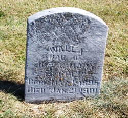
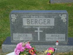
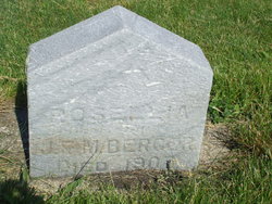
Walla “Maggie” Berger
| Birth | : | 1 May 1895 Indian Creek Township, Pulaski County, Indiana, USA |
| Death | : | 21 Jan 1901 Indian Creek Township, Pulaski County, Indiana, USA |
| Burial | : | United Reformed Churchyard, Long Buckby, Daventry District, England |
| Coordinate | : | 52.3016430, -1.0793930 |
| Description | : | Death certificate reads Maggie Berger |
frequently asked questions (FAQ):
-
Where is Walla “Maggie” Berger's memorial?
Walla “Maggie” Berger's memorial is located at: United Reformed Churchyard, Long Buckby, Daventry District, England.
-
When did Walla “Maggie” Berger death?
Walla “Maggie” Berger death on 21 Jan 1901 in Indian Creek Township, Pulaski County, Indiana, USA
-
Where are the coordinates of the Walla “Maggie” Berger's memorial?
Latitude: 52.3016430
Longitude: -1.0793930
Family Members:
Parent

Siblings
Flowers:


Nearby Cemetories:
1. United Reformed Churchyard
Long Buckby, Daventry District, England
Coordinate: 52.3016430, -1.0793930
2. Long Buckby & Brington Baptist Church
Long Buckby, Daventry District, England
Coordinate: 52.3022756, -1.0804149
3. St. Lawrence Churchyard
Long Buckby, Daventry District, England
Coordinate: 52.3042680, -1.0815040
4. Watford Village Cemetery
Watford, Daventry District, England
Coordinate: 52.3168542, -1.1102416
5. St. Andrew Churchyard
Whilton, Daventry District, England
Coordinate: 52.2776040, -1.0683450
6. St. Peter and St. Paul Churchyard
Watford, Daventry District, England
Coordinate: 52.3160210, -1.1163920
7. East Haddon Churchyard
East Haddon, Daventry District, England
Coordinate: 52.3076000, -1.0224800
8. All Saints Churchyard
West Haddon, Daventry District, England
Coordinate: 52.3409590, -1.0764700
9. St Mary the Virgin with St John Churchyard
Great Brington, Daventry District, England
Coordinate: 52.2810470, -1.0235660
10. All Saints Churchyard
Norton, Daventry District, England
Coordinate: 52.2681250, -1.1180030
11. St. Martin's Churchyard
Welton, Daventry District, England
Coordinate: 52.2893100, -1.1494100
12. St Denys' Church
Northampton Borough, England
Coordinate: 52.3271318, -1.0182438
13. Welton Cemetery
Welton, Daventry District, England
Coordinate: 52.2932126, -1.1567336
14. Blessed Virgin Mary and St Leodegarius Churchyard
Ashby St Ledgers, Daventry District, England
Coordinate: 52.3090000, -1.1606000
15. Crick United Reformed Churchyard
Crick, Daventry District, England
Coordinate: 52.3469872, -1.1339944
16. All Saints Churchyard
Holdenby, Daventry District, England
Coordinate: 52.3021000, -0.9868100
17. St. Michael and All Angels Churchyard
Winwick, Daventry District, England
Coordinate: 52.3589063, -1.0820887
18. Spencer Estate Grounds
Althorp, Daventry District, England
Coordinate: 52.2839190, -0.9889520
19. St. Margaret Churchyard
Crick, Daventry District, England
Coordinate: 52.3476230, -1.1378110
20. Welton Road Daventry
Daventry, Daventry District, England
Coordinate: 52.2643510, -1.1590460
21. St Etheldreda Churchyard
Guilsborough, Daventry District, England
Coordinate: 52.3480310, -1.0089780
22. St Mary the Virgin Churchyard
Dodford, Daventry District, England
Coordinate: 52.2396800, -1.1044500
23. St James Churchyard
Hollowell, Daventry District, England
Coordinate: 52.3404638, -0.9912752
24. A5 Watling Street Cemetery
Kilsby, Daventry District, England
Coordinate: 52.3363016, -1.1732250